logo


Cabo Verde Latitude and Longitude Map

Cabo Verde's latitude and longitude is 16° 00' N and 24° 00' W . Below is the map of Cabo Verde showing major towns, roads, airports with latitudes and longitudes plotted on it.
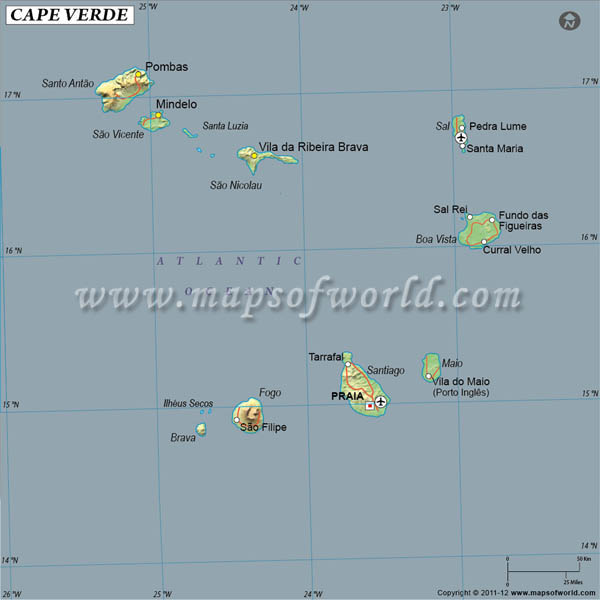
Cabo Verde Latitude and Longitude Map
Description : Find Cabo Verde latitude and longitude map showing comprehensive details including cities, roads, towns, airports and much more. Disclaimer
×

Disclaimer  :  All efforts have been made to make this image accurate. However MapSherpa, Inc, its directors and employees do not own any responsibility for the correctness or authenticity of the same.


Search For Latitude & Longitude Map

By Country

Or

Latitude

Longitude

Or

Area

* Put South & West values with minus ( - ) sign.


The Latitude and Longitude of Cabo Verde is 16° 00' N and 24° 00' W respectively. The particular latitude of Cabo Verde suggests its location in the northern hemisphere.

This country is situated amid cluster of Islands in North Atlantic Ocean at the west of Senegal.

The country of Cabo Verde occupies 4,033 square kilometer of area. The terra firma of Cabo Verde is characterized by volcanoes, cliffs, crags and steep hills. The climatic condition of this land is known as moderate weather. The summer season is semiarid and hot whereas rainfall is not enough and the weather is extremely unpredictable. The latitude and the longitude of Praia, the capital of Cabo Verde is 14° 55' N and 23° 31'W respectively. The difference of time indicates UTC-1.

Latitude and Longitude of Cabo Verde

LocationLatitudeLongitude
15°02'N23°34'W

Last Updated on: June 17, 2020