4.9K
- Greece Cities - Alaxandroupolis, Corinth, Heraklion, Ioannina, Kalamata, Kavala, Patra, Sparta, Thessaloniki, Volos
- Greece Regions - Attica, Central Greece, Crete, East Macedonia and Thrace, Epirus, Ionian Islands, Macedonia Central, Mount Athos, North Aegean, Peloponnese, South Aegean, Thessaly, West Greece, West Macedonia
- Neighboring Countries - Albania, Macedonia, Turkiye, Bulgaria
- Continent And Regions - Europe Map
- Other Greece Maps - Greece Map, Where is Greece, Greece Blank Map, Greece Road Map, Greece Rail Map, Greece River Map, Greece Flag
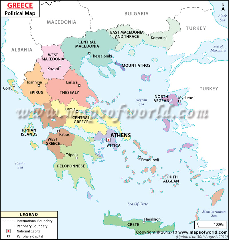
Greece is located in southern Europe and shares land boundaries with Albania, the Republic of Macedonia, Bulgaria, and Turkey. Administratively, Greece is divided into thirteen regions and one autonomous administrative unit.
The thirteen administrative units(Greece)–
- Attica in south-central Greece covers an area of about 1470 square miles (approximately 3808 square kilometers) and is home to a population of about 3,750,000. The national capital, Athens is also the capital of Attica.
- Eastern Macedonia and Thrace is the northernmost administrative region of the country and covers an area of 5466 square miles (about 14,157 kilometers). With a population of 606, 170, the region has its capital at Komotini.
- The administrative unit of Central Macedonia, with its capital at Thessaloniki covers an area of about 6,004 square miles (approximately 15,549 square kilometers) and houses a population of 1,874,590 people.
- Western Macedonia, to the southwest of Central Macedonia and to the north of Epirus and Thessaly covers an area of 3,649 square miles (about 9,451 square kilometers). With its capital at Kozani, Western Macedonia has a population of 282,120.
- Epirus is the westernmost administrative region of peninsular Greece. It has its capital at Ioannina. Epirus covers a land area of 3,553 square miles (about 9,023 square kilometers) and has a population of 336,650.
- The Ionian Islands cover all the islands in the Ionian Sea except Kythera. The island of Corfu is the capital of the Ionian Islands region. The land area of the region covers 891 square miles (about 2,307 square kilometers) and the islands together are home to a population of 206, 470.
- Thessaly, to the south of Western Macedonia, houses a population of 730,730. Larissa is the capital of Thessaly. The administrative unit covers an area of 5,420 square miles (about 14,037 square kilometers).
- Central Greece to the north of Attica, has its capital at Lamia. Central Greece covers an area of about 6,004 square miles (15,549 square kilometers) and has about 546,870.
- West Greece is located to the north of the Peloponnese, has a population of 680, 190 and covers an area of about 3,649 square miles (9,451 square kilometers) Patras is the capital of West Greece.
- The Peloponnese is the southernmost region of peninsular Greece. Tripoli is the capital of the Peloponnese and covers an area of 5,981 square miles (15,490 square kilometers). The region has a population of 581,980.
- The North Aegean region covers 1481 square miles (about 3836 square kilometers). The capital of the North Aegean is Mytilene. The North Aegean islands are home to a population of 197,810.
- The South Aegean islands form an administrative region covering 2,041 square miles (5,286 square kilometers). With its capital at Ermoupoli, the region has a population of 308,610.
- Crete with its capital at Heraklion has a population of 621,340. The region covers a land area of 3,189 square miles (8,259 square kilometers).
Besides the administrative regions, Mount Athos is an autonomous administrative unit and covers an area of 151 square miles (390 square kilometers). With its capital at Karyes, Mount Athos has a population of 1,830.
| Administration | Population | Area(km.²) | Area(mi.²) | Capital |
|---|---|---|---|---|
| Aegean | 503,697 | 9,122 | 3,522 | Piraeus |
| Attica | 3,894,573 | 3,808 | 1,470 | Athens |
| Crete | 594,368 | 8,336 | 3,219 | Heraklion |
| Epirus and Western Macedonia | 630,709 | 18,654 | 7,202 | Ioannina |
| Macedonia and Thrace | 2,481,759 | 32,969 | 12,729 | Thessaloniki |
| Mount Athos | 1,961 | 336 | 130 | Karyai (Karyes) |
| Peloponnese, Western Greece, and the Ionian Islands | 1,528,771 | 29,147 | 11,254 | Patras |
| Thessaly and Central Greece | 1,298,259 | 29,586 | 11,424 | Larissa |
| 8 divisions | 10,934,097 | 131,958 | 50,950 |
