- National Park Maps of Neighbouring States - Washington National Parks, Idaho National Parks, California National Parks, Nevada National Parks
- National Parks in Oregon - Crater Lake National Park
- US National Parks Map
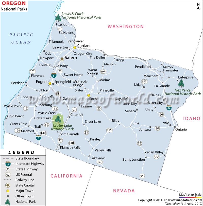
The Map of Oregon National Parks prominently marks the several national parks, historical sites, and national monuments of the state.
Lewis and Clark National Historical Park, California National Historic Trail, Mcloughlin House National Historic Site, Lewis & Clark National Historic Trail, Oregon Caves National Monument, Crater Lake National Park, Oregon National Historic Trail, John Day Fossil Beds National Monument, Fort Vancouver National Historic Site and Nez Perce National Historical Park are some of the prominent national parks of the state.
The Oregon State Map indicates the accurate geographical location of the various national parks of the state. Situated in the southern part of Oregon, the Crater Lake National Park is one of the notable tourist destinations of the state. The John Day Fossil Beds National Monument reflects the rich ancestry of the state.
The Museums of Sheep Rock of the John Day Fossil Beds National Monument is one of the major attractions of the place. The Nez Perce National Historical Park represents the rich cultural traditions of the state.
How Many National Parks in Oregon?
Oregon has officially only one national park in the state that is Crater Lake national park. The park stands out for its clear blue waters and Caldera of Crater lake. Other than that there are 360 miles of Public beaches, gorges, wild rivers, forested peaks, and fossil-rich desert in the state. The other parks such as Lewis and Clark National Historical Park and Nez Perce National Historical Park are some of the prominent national parks of the state marked on the map.
National Parks in Oregon State |
|---|
| S. No | Name | Area | Established | Location |
|---|---|---|---|---|
| 1 | Crater Lake National Park | 183,224 acres (286.288 sq mi; 74,148 ha; 741.48 km2) | May 22, 1902 | Klamath County, Oregon, United States of America |
| 2 | Lewis and Clark National and State Historical Parks | 3,303 acres (1,337 ha) | May 29, 1958 | Clatsop County, Oregon and Pacific County, Washington, USA |
| 3 | Nez Perce National Historical Park | 4,561 acres (1,846 ha) | May 15, 1965 | Idaho, Montana, Oregon, Washington, United States |
National Parks in Oregon State
-
Crater Lake National Park:
The park is located in the Cascade Mountains of southern Oregon. This park has the deepest lake in the USA and one of the most pristine on earth. With a depth of 1,943 feet, Crater lake is an indication of its great depth and purity as it is the cleanest and clearest large body of water in the world.
Crater Lake itself occupies less than 10% of the park. Beyond the lake, old-growth forests blanket the landscape. -
Lewis and Clark National Historical Park:
This park is located in the vicinity of the mouth of the Columbia River. The park surrounds sites along the Columbia River and Pacific coast. Administration of the park includes both federal and state lands.
It is a cooperative effort of the National Park Service and the States of Oregon and Washington. One can explore the timeless rainforests and majestic coastal Vistas. Unfold the dramatic stories of America’s most famous explorers. -
Nez Perce National Historical Park:
The park comprises 38 sites located throughout the states of Idaho, Montana, Oregon, and Washington. This parking service administers nine of these sites.
The park includes traditional aboriginal lands of Nez Perce people. Numerous animal species also inhabit the park. One can explore all these places and learn from the stories of Nimiipuu.
Activities to do in National Parks in Oregon
- Exploring a collapsed Volcano in Crater lake national park. The park has an abundance of fascinating volcanic features, including a second rocky island, the phantom ship. The Rim Drive offers views of the park’s volcanic formations.
- One can visit Wizard Island near the Western edge of Crater Lake.
- Exploring the Nez Perce Historical park exhibits at the main visitor center at the Spalding Site.
- Fort Clatsop comes alive during summer and winter Rangers programs in Lewis and Clark National Historical Park. Learn about the historical, cultural, and natural resources of the area around Fort Clatsop.
- One can Hop in a watercraft and Paddle along the lush riverbanks of the Lewis and Clark River.
- One can include a stretch of the Lewis and Clark Columbia River Water Trail, as there are plenty of opportunities to spot wildlife.
Best time to visit National Parks in Oregon
The most popular months to visit national parks in Oregon are July, August, and September. That’s when the park’s roads, trails, and facilities are usually fully open. May and June are months of transition in the park, as winter slowly gives way to Summer.
The lingering snow can prevent us from accessing much of the park. Many facilities close in winter as well due to the snow.
