Check this Florida County Map to locate all the state’s counties in Florida Map.
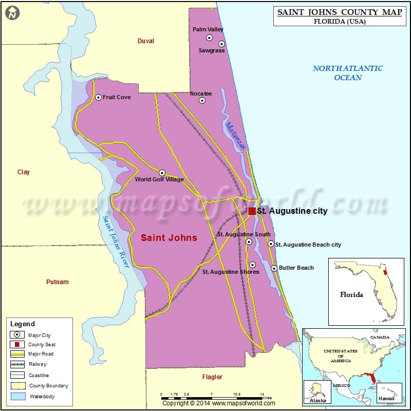
St Johns County
St Johns County is an important county in Florida and is also home to St. Augustine, which is the county seat as well as the largest incorporated city. Named for the St. Johns River, the county was formed in 1821. The county is spread over an area of 822 square miles. Of this, 6-1 square miles is land, while 221 square miles is water. As of 2010, the population of St Johns county was 190,039. Some of the counties adjacent to St John’s County include Duval County, Flagler County, Putnam County, and Clay County. The prominent airport included in the county is the Northeast Florida Regional Airport.
Some of the prominent places of attraction in the county include Old St Johns County Jail, St Augustine Amphitheater, and Lightner Museum, among others.
Mountain Peaks in St. Johns County
| Mountain Peak/Hill | Elevation [Meter] |
|---|---|
| Squirrel Hill | 9 |
Airports in St. Johns County
| Airport Name |
|---|
| Byrd Air Field |
| Earle Airpark |
| Flagler Hospital Heliport |
| Kathrinstadt Airport |
| Raceland Station Heliport |
| St Augustine Airport |
| Sunshine Farms Airport |
| Sylvanmir Farms Airport |
| Tater Farms Strip |
| Tocoi Airport |
Cities in St. Johns County
| City | Population | Latitude | Longitude |
|---|---|---|---|
| Butler Beach | 4951 | 29.797962 | -81.265292 |
| Crescent Beach | 931 | 29.734972 | -81.241137 |
| Flagler Estates | 3215 | 29.644139 | -81.456991 |
| Fruit Cove | 29362 | 30.097257 | -81.617582 |
| Hastings town | 580 | 29.710435 | -81.510151 |
| Nocatee | 4524 | 30.091737 | -81.409712 |
| Palm Valley | 20019 | 30.201158 | -81.394813 |
| Sawgrass | 4880 | 30.189763 | -81.370194 |
| St. Augustine Beach city | 6176 | 29.84134 | -81.271327 |
| St. Augustine city | 12975 | 29.897904 | -81.309987 |
| St. Augustine Shores | 7359 | 29.803813 | -81.308644 |
| St. Augustine South | 4998 | 29.84491 | -81.315597 |
| Villano Beach | 2678 | 29.935503 | -81.301963 |
| World Golf Village | 12310 | 29.96531 | -81.489834 |
Golf Courses in St. Johns County
| Name of Golf Course | Latitude | Longitude |
|---|---|---|
| Champions at Julington Creek-Jacksonville | 30.110554 | -81.609657 |
| Cimarrone Golf & Country Club-Jacksonville | 30.063111 | -81.543796 |
| Golf Club At South Hampton-Saint Augustine | 30.046848 | -81.548024 |
| King and Bear Golf Course/World Golf Village-Saint Augustine | 29.959727 | -81.518597 |
| Marsh Creek Country Club-Saint Augustine | 29.838924 | -81.280195 |
| Marsh Landing Country Club-Ponte Vedra Beach | 30.241942 | -81.405488 |
| Pablo Creek Club-Jacksonville | 30.25193 | -81.437039 |
| Palm Valley Golf Club-Ponte Vedra Beach | 30.13524 | -81.381669 |
| Ponte Vedra Club-Ponte Vedra Beach | 30.242148 | -81.37889 |
| Ponte Vedra Golf and Country Club At Sawgrass-Ponte Vedra Beach | 30.215366 | -81.392159 |
| Royal St. Augustine Golf and Country Club-Saint Augustine | 29.906983 | -81.352553 |
| Sawgrass Country Club-Ponte Vedra Beach | 30.188439 | -81.369175 |
| Slammer and Squire Golf Course/World Golf Village-Saint Augustine | 29.991892 | -81.471166 |
| St. Augustine Shores Golf Course-Saint Augustine | 29.792638 | -81.310752 |
| St. Johns Golf and Country Club-Saint Augustine | 30.055295 | -81.508385 |
| St. Johns Golf Club-Elkton | 29.801417 | -81.382121 |
| The Palencia Club-Saint Augustine | 30.013914 | -81.391246 |
| The Plantation at Ponte Vedra-Ponte Vedra Beach | 30.163619 | -81.375535 |
| TPC at Sawgrass-Ponte Vedra Beach | 30.202556 | -81.394066 |
National Parks in St. Johns County
| Name of Park | Latitude | Longitude |
|---|---|---|
| Castillo de San Marcos NM | 29.897947 | -81.312489 |
| Fort Matanzas NM | 29.716189 | -81.234421 |
| Fort Matanzas NM | 29.71079 | -81.239013 |
 Wall Maps