Is the State of Florida a Peninsula?
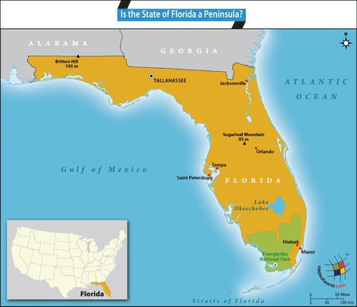
Yes. The state of Florida is a peninsula.
A peninsula is explained as a land projection that is connected to the mainland but surrounded by water on three sides. Florida fulfills this definition since it is surrounded by waters on three sides – the Gulf of Mexico to its west, the Atlantic Ocean to its east, and the Straits of Florida to its south. The state has 1,200 miles of coastline and shares its northern borders with the states of Georgia and Alabama.
Located at Latitude 24° 30’ to 31’ N and Longitude 79° 48’ W to 87° 38’ W, Florida is spread over 65,755 sq. miles, stretching 361 miles from east to west and 447 miles from north to south. The extensive coastline includes 663 miles of beaches. The average elevation of the state is 100 feet, with large parts located at or close to sea level.
The peninsula sits on a karst limestone plateau located on a bedrock called the Florida Platform. The state includes smaller peninsulas and includes Fairpoint Peninsula, St John’s River Peninsula, Pinellas Peninsula, Interbay Peninsula, and Cape Sable.
The state can be classified into four regions: Florida Keys – an archipelago comprising 1,700 islands; Everglades – an international bio-reserve and a World Heritage Site; Coastal plains of the Gulf Coast and Atlantic Coast; and the Uplands of north and northwest Florida.
Major rivers flowing in the state include St Johns, Caloosahatchee, Apalachicola, Kissimmee, Suwannee, and Indian. The largest water body in the state is Lake Okeechobee. The highest point in the state is Britton Hill at 345 ft., while Sugarloaf Mountain stands at 312 ft. and also happens to be the highest in peninsular Florida.
The weather in the state is mostly subtropical and humid for most of the year with the average daily temperature holding at 70.7° F. The state receives between 2,800 to 3,200 hours of sunshine annually, giving it the nickname “Sunshine State”.
Given its proximity to the Gulf of Mexico and the Atlantic Ocean and with the Gulf Stream flowing through the southern straits, Florida is frequented by hurricanes that can be devastating.
On October 24, 2005, Hurricane Wilma, a Category-3 hurricane made landfall with extreme consequences, making it the most damaging hurricane by value, up to that time. Since then, the state recorded 68 Atlantic hurricanes through September 2016 and nine tropical storms between 2006 and 2016.
Florida Everglades
The 2 million-acre Everglades is an extensive wetland ecosystem located at the southern end of the Florida peninsula. It is the only one of its kind on the planet and is home to diverse flora and fauna. The Kissimmee River feeds into Lake Okeechobee, which in turn, overflows during the monsoons, forming a shallow slow-moving flood that spreads across the extensive “Rivers of Grass” that cover the area.
Over 10,000 islands form part of the ecosystem with distinct biodiversity. The Everglades National Park has been declared a World Heritage Site for its fragile ecosystem and endangered species that are found there. The Park is home to over 350 bird species, 27 types of snakes, and large numbers of alligators and crocodiles. Endangered species that live there include; the Florida Panther, of which only 80 remain, the Bottlenose Dolphin, and the West Indian Manatee.
Other quick facts about Florida
Florida was established on March 3, 1845, and is the 27th state to join the Union. Tallahassee is the state capital. Other cities of the state with high populations include Jacksonville, Miami, Tampa, Orlando, St. Petersburg, and Hialeah.
As per U.S. Census Bureau, Florida is home to 20,612,439 people (2016 est.) with a population per square mile density of 350.6 (2010 est.).
Related Links:
- Key Facts about Florida
- Places to visit in Florida
- Amusement Parks in Florida
- What is Florida known for?
Related Maps: