- Wisconsin Counties - Wisconsin County Map, Map of Wisconsin Counties
- Major Cities of Wisconsin - Madison, Milwaukee
- Neighbouring States - Minnesota, Michigan, Iowa, Illinois
- Regional Maps - Map of USA
- Other Wisconsin Maps - Wisconsin Map, Where is Wisconsin, Wisconsin Physical Map, Wisconsin Lat Long Map, Wisconsin Zip Code Map, Wisconsin Area Code Map
Airports in Wisconsin
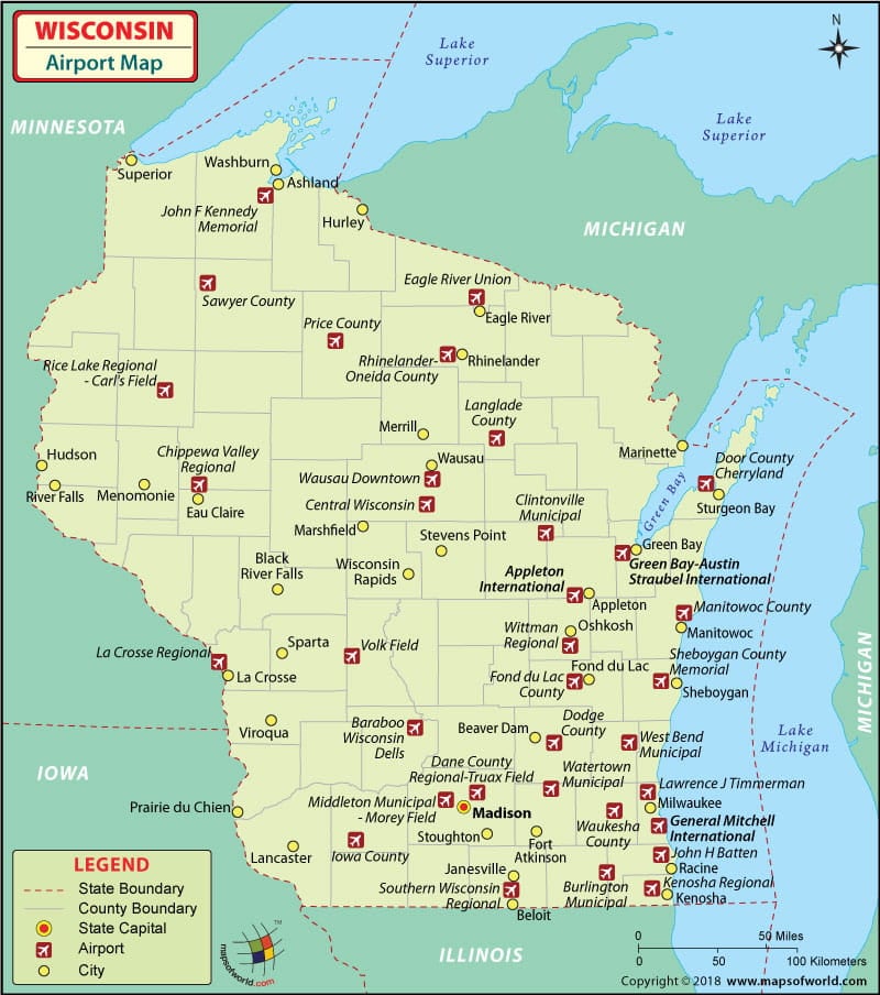
There are 132 airports in Wisconsin for the public to use. The airports in Wisconsin are well connected to major cities in USA. Airports in Wisconsin provide quality service to the customers and have the latest in aviation technology.
The international airports in Wisconsin are the Austin Straubel International Airport at Green Bay and the General Mitchell International Airport at Milwaukee.
The General Mitchell International Airport in Milwaukee is the busiest of all the airports in Wisconsin. It serves more than six million people annually. The airport offers many amenities and services for its customers. It has coffee shops, a used-books’ store, a conference room, a food-court, restaurant and banquet facilities, news and gifts shop, banking facilities, other retail stores and a family-care-room.
The airport is also disabled-friendly. It has TDD phones for the hearing impaired, accessible restrooms and convenient parking spots. Skycap assistance is also provided for those who seek it.
The airlines that serve the airport are Comair, Delta Airlines, Air Canada, USA 3000, Northwest Airlines, American Eagle, Midwest Airlines, Continental Express, Frontier Airlines, United Express, AirTran Airways and US Airways Express.
The Austin Straubel International Airport in Green Bay is the third busiest airport in the state of Wisconsin. It has ATMs, banking facilities, paging service, facilities for people with disabilities, a photo kiosk and wireless Internet facility spread out all over its terminal. The airport also has a business center with necessary support systems. The airlines that serve the airport are Allegiant Air, United Express, Northwest (Airlink), American Eagle, Midwest Express and Delta Connection.
Maps of Major Airports in Wisconsin
List of Airports in Wisconsin |
|---|
| Airport Name | City | Coordinates |
|---|---|---|
| Outagamie County Regional Airport | Appleton | 44°15′29″N 088°31′09″W |
| Chippewa Valley Regional Airport | Eau Claire | 44°51′57″N 091°29′03″W |
| Austin Straubel International Airport | Green Bay | 44°29′05″N 088°07′47″W |
| La Crosse Regional Airport | La Crosse | 43°52′45″N 091°15′24″W |
| Dane County Regional Airport | Madison | 43°08′23″N 089°20′15″W |
| General Mitchell International Airport | Milwaukee | 42°56′50″N 087°53′48″W |
| Central Wisconsin Airport | Wausau | 44°46′39″N 089°40′00″W |
| Rhinelander-Oneida County Airport | Rhinelander | 45°37′51″N 089°27′59″W |
| Boulder Junction Airport | Boulder Junction | 46°08′15″N 089°38′46″W |
| Chetek Municipal-Southworth Airport | Chetek | 45°18′22″N 091°38′10″W |
| Cornell Municipal Airport | Cornell | 45°09′55.88″N 91°06′20.51″W |
| Joshua Sanford Field | Hillsboro | 43°39′24″N 090°19′41″W |
| Necedah Airport | Necedah | 44°02′00″N 090°05′06″W |
| Prentice Airport | Prentice | 45°32′19″N 090°16′33″W |
| Gilbert Field | Rio | 43°27′0″N 89°15′0″W |
| Bloyer Field | Tomah | 43°58′34″N 090°28′50″W |
| Verona Airport | Verona | 42°59′22″N 089°30′34″W |
 Wall Maps