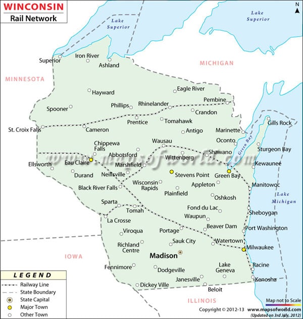
The Wisconsin Railway Map offers comprehensive information on the several rail routes running through the state. The foremost railway line of Wisconsin was constructed during the year of 1850 that ran from Milwaukee region to Prairie du Chien. During the later half of the 1860s, the railroad companies of the Chicago, Milwaukee, and St. Paul and the Chicago and Northwestern played an important role in developing the transportation systems of the state. The well laid railway tracks of Wisconsin help in the intra and inter-state connectivity. The Freight railroads of Wisconsin serve the industrial and manufacturing units of the state. The freight railways cover total route of 3,400 miles. There are 11 freight railroads of Wisconsin. The Passengers trains of Wisconsin are managed and supervised by Amtrak railroad. Empire Builder is a well known passenger train that connects Chicago with Portland and Seattle. The train stops at six stations of Wisconsin. The Hiawatha Service is another famous passenger train that caters to almost 624,000 passengers and connects Chicago with Milwaukee. The Wisconsin Department of Transportation has formulated special measures to ensure safety and security of the passengers. The Wisconsin State Map is a useful guide to the tourists of the state.
Wisconsin Rail Map
The Wisconsin Railway Map offers comprehensive information on the several rail routes running through the state. The foremost railway line of Wisconsin was constructed during the year of 1850 that…
3.3K
previous post
 Wall Maps