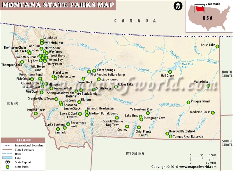
There’s more to explore in Montana than geysers in Yellowstone and snow-clad summits in Glacier National Park. There are more than 40 state parks in Big Sky Country under the Montana Department of Fish, Wildlife and Parks. Established in 1938, Lewis and Clark Caverns State Park is the oldest state park in Montana. Famous for limestone caverns, amenities in the park include bicycling, bird watching, camping, fishing, hiking, and picnicking.
At more than 11,000 acres, Makoshika State Park is the largest of all state parks in Montana. It is home to spectacular badlands which contain dinosaur fossils. Its visitor center exhibits a small museum with displays related to fossils. Visitors find beauty in these badlands of Montana by taking a scenic drive or exploring nature trails on foot. The 5,603-acre Fish Creek State Park is the Montana’s second largest state park. Opportunities for hiking, fishing, and mountain biking are abound here. First Peoples Buffalo Jump State Park features North America’s largest buffalo jump that was utilized by the Native American tribes.
Fort Owen State Park, known as the “cradle of Montana civilization”, was settled by catholic missionaries in 1840s. Missouri Headwaters State Park is the site where the Missouri River starts its 2300-mile-long journey. Tower Rock State Park features a 129-meter-high rock formation that is a prominent landmarks in the region. Giant Springs State Park, Black Sandy State Park, Lost Creek State Park, Medicine Rocks State Park, and Thompson Falls State Park are other some of the state parks in Montana.
MOW.DT.12.20.16
 Wall Maps