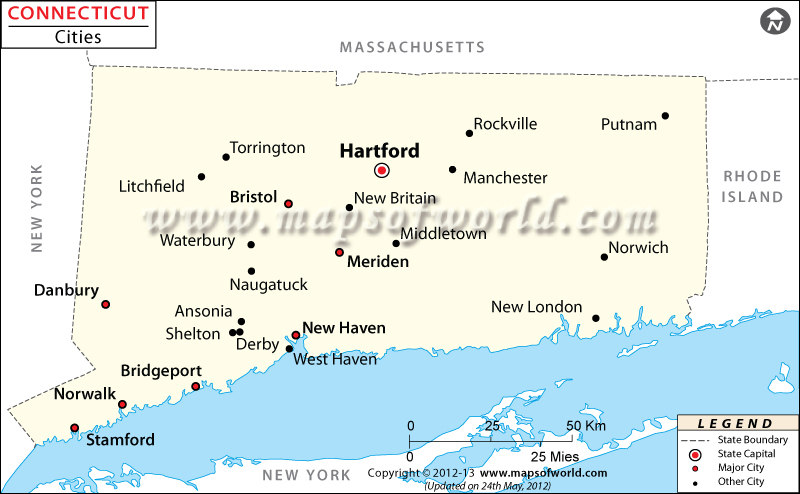
Connecticut City Maps

Connecticut is the third smallest state by area in the United States. Cities in the state are dependent municipalities and are situated within and subordinate to a town. Barring one city, the rest are consolidated with their parent town. Bridgeport is the largest city in the state by population. According to the 2010 census, the city had a population of 144,229 inhabitants. New Haven is the second-largest city with a population of 129,779. Hartford, the capital of Connecticut, is the third-largest city in the state and has a population of 124,775, per the 2010 census. Stamford and Waterbury are the fourth and fifth largest cities and comprised populations of 122,643, and 110,366 inhabitants, respectively.
Birthplace of the Frisbee, Bridgeport is the largest city by population in the state. Nicknamed ‘The Elm City’, New Haven is the home of Yale University which was established in 1701.
Founded in 1637, Hartford is the state capital and among the oldest cities in the US. The city houses Bushnell Park and the Wadsworth Atheneum (America’s oldest public art museum) and publishes The Hartford Courant, the oldest continuously published newspaper.
Bristol is home to the central studios of ESPN and America’s oldest still-functioning amusement park, Lake Compounce. Stamford, about 30 miles from Manhattan, is the third-largest city in Connecticut. Waterbury, Norwalk, Danbury, and Meriden are other notable cities in Connecticut.
Getting In and Around
Bradley International Airport (BDL) in Hartford County is the gateway to the state.
Amtrak operates Northeast Regional and Acela Express through the state.
I-95, I-84, and I-91 are three primary interstate highways in Connecticut.
List of Cities in Connecticut by Population |
|---|
| City Name | County | Population |
|---|---|---|
| Ansonia | New Haven | 18,531 |
| Bridgeport | Fairfield | 144,229 |
| Bristol | Hartford | 61,353 |
| Danbury | Fairfield | 80,893 |
| Derby | New Haven | 12,903 |
| Groton | New London | 10,010 |
| Hartford | Hartford | 124,775 |
| Meriden | New Haven | 59,653 |
| Middletown | Middlesex | 47,481 |
| Milford | New Haven | 52,759 |
| New Britain | Hartford | 71,254 |
| New Haven | New Haven | 129,779 |
| New London | New London | 27,620 |
| Norwalk | Fairfield | 85,603 |
| Norwich | New London | 40,493 |
| Shelton | Fairfield | 39,559 |
| Stamford | Fairfield | 122,643 |
| Torrington | Litchfield | 36,383 |
| Waterbury | New Haven | 110,366 |
| West Haven | New Haven | 52,721 |
| Winsted | ||
| Administered by the town of Winchester |
Litchfield | 7,321 |
 Wall Maps