- Japan Cities - Hiroshima, Sagamihara, Tokyo
- Neighboring Countries - South Korea, North Korea, China, Russia
- Continent And Regions - Asia Map
- Other Japan Maps - Japan Map, Where is Japan, Japan Blank Map, Japan Road Map, Japan Rail Map, Japan River Map, Japan Political Map, Japan Flag
Japan is an island country situated in the northwest Pacific Ocean in East Asia. The Sea of Japan borders the island country on the west, the sea of Okhotsk in the north, and the East China Sea and Taiwan in the south.
Physical Features of Japan
Japan spans an archipelago of 6852 islands, of which five main islands are Honshu (the mainland), Hokkaido, Shikoku, Okinawa, and Kyushu. The Nanpo and Ryukyu Islands are east and south of the main islands, constituting the Japanese Archipelago.
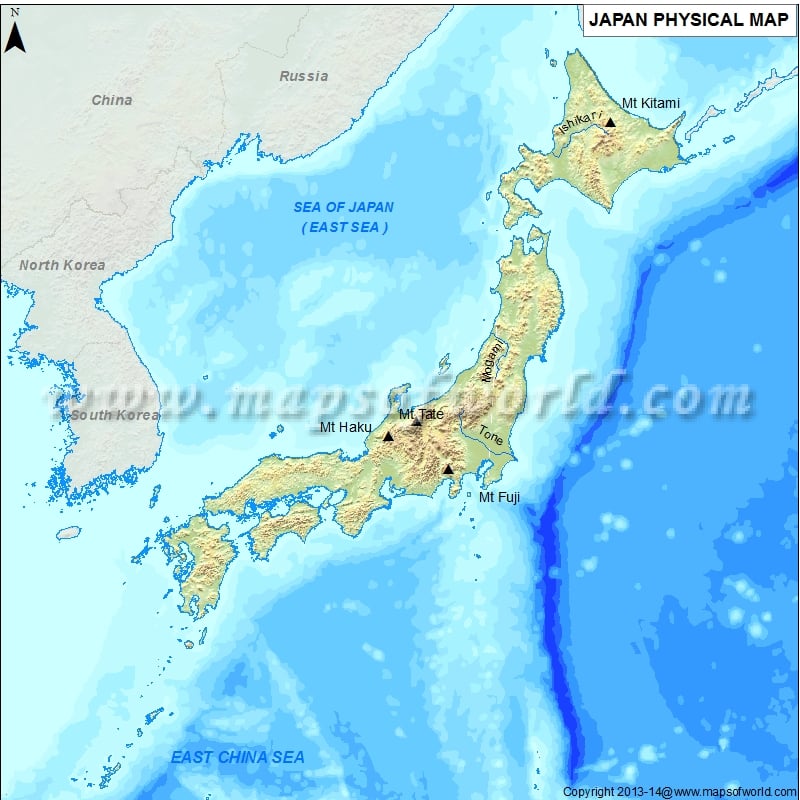
The Japan Physical Map is useful for school presentations and other purposes. A map legend at the bottom helps all the signs, characters, graphics, and symbols used throughout the map. Japan covers 377,975 square kilometers (145,937 sq mi) and stretches northeast-southwest from the Sea of Okhotsk to the East China Sea over 3000 km (1900 mi). Tokyo is the largest capital city of Japan. The island country is located in the northwestern Ring of Fire, and the terrain is mostly mountains and rugged. The topography of Japan can be further divided into:
Mountains and Volcanoes
73% of the country is approximately mountainous. The long mountain range runs through each of the main islands in the middle of the Japanese Archipelago, dividing it into two halves. The first one is fronting the Pacific Ocean called “face”, and the other is towards the Sea of Japan called “back”. The mountain ranges on the Pacific side are about (1,500 to 3,000 m) with deep valleys and gorges. On the seaside of Japan, there are low mountain districts and plateaus of about (500-1500 m). The three mountain ranges, Kiso, Hids, and Akaishi mountains, converge in central Japan and form the Japanese Alps. At 3,193 meters (10,476 ft), Mount Kita is the highest point in the Japanese Alps. The highest mountain in Japan is Mount Fuji has an elevation of about 3,776 m (12,388 ft) above sea level. It is a dormant volcano located on the island of Honshu 100 km southwest of Tokyo.
Plains
Plains cover about 27% of the total land area of the country. The three most significant plains in Japan located on Honshu Island are:
-
Kanto Plain:
The Plain covers 17,000 km2 (6,600 sq mi) in the Kanto region. This plain consists of the capital city of Tokyo and has the largest metropolitan population.
-
Nobi Plain:
The Plain covers a total area of 1,800 km2 (690 sq mi). The third most populated area of the country, Nagoya, is located in this region.
-
Osaka Plain:
This Plain covers 1600 km2 (620 sq mi) in the Kinki region. It consists second-largest urban area of Osaka, which is part of the Keihanshin metropolitan area. The Osaka Plain is further connected with Nara and Kyoto. Nara lies in the Nara Basin, and Kyoto is located in the Yamashiro Basin.
The island of Hokkaido has multiple plains such as Tokachi Plain, Ishikari Plain, Kushiro Plain, and the Sarobetsu Plain.
Rivers and Lakes in Japan
The most significant river in Japan is the Shinano River, 367 km (228 mi), which flows into the Sea of Japan. The other significant rivers are Tone River, Ishikari River, Tashio River, Agano River, and Shimato River. Important Lakes of Japan include Lake Biwa, Saroma lake, Nakaumi lake, Toya lake, etc. Lake Biwa is the largest freshwater lake in the country.
