New Mexico City Maps
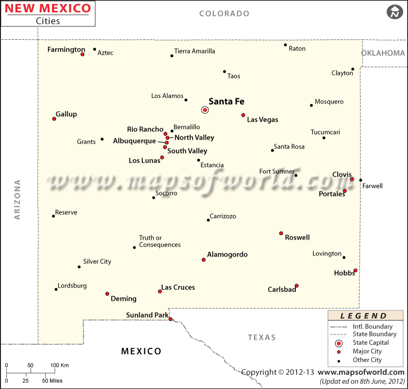
New Mexico is one of the Mountain States and the fifth largest state by area in the United States. It is the 36th most populated state in the country. Albuquerque is the most populated city in New Mexico. As of 2016, the city had an estimated population of 559,277 people. Las Cruces is the second largest city, with a population of 101,759 inhabitants. Rio Rancho is the third largest city and has a population of 96,028. Santa Fe is the capital of New Mexico and the fourth largest city in the state. As of 2016, the city had an estimated population of 83,875 people. Other cities that have a population of more than 30,000 people are Roswell, Farmington, and Clovis. Grenville, a village in Union County, is the least populated. As of 2016, Grenville had a population of around 34 inhabitants.
Nicknamed the “Land of Enchantment“, the state of New Mexico is located in the southwestern United States. The state is known for vast deserts, rugged flat-topped hills, the hit AMC series Breaking Bad, and a cultural heritage with strong Hispanic and Native American influences.
The largest city in the state, Albuquerque, hosts the International Balloon Fiesta (a yearly festival of hot air balloons) during the first week of October. Popular places to visit in the city are: Albuquerque Biological Park, Albuquerque Museum, Museum of Natural History and Science, and Old Town Albuquerque.
Las Cruces, or “The City of the Crosses”, is located near the Organ Mountains in the Mesilla Valley. With an elevation of 2,194 meters, Santa Fe is the highest state capital in the US. The city of Clovis is known for its role in early rock music history. Farmington, Roswell, and Rio Rancho are other cities in New Mexico worth visiting.
Getting In and Around
Albuquerque International Sunport (ABQ) is the primary international gateway to the state. Amtrak’s Southwest Chief, Texas Eagle, and Sunset Limited provide train connectivity to major cities in New Mexico. I-10, I-25, and I-40 along with US 54, US 60, US, 64, and US 285 create a dense road network in the state.
List of Cities in New Mexico |
---|
|
-
Map of Wagon Mound Village, New Mexico shows its location on a Google Map with its longitude and latitude. You can also buy the Wagon Mound Village map printed on paper, laminated or on rolled canvas form from our online map store MapTrove This map can also be customized with different area, orientation or scale on MapTrove.com. The population of Wagon Mound Village is 314.
-
Map of Zuni Pueblo City, New Mexico shows its location on a Google Map with its longitude and latitude. You can also buy the Zuni Pueblo City map printed on paper, laminated or on rolled canvas form from our online map store MapTrove This map can also be customized with different area, orientation or scale on MapTrove.com. The population of Zuni Pueblo City is 6302.
-
Map of Waterflow City, New Mexico shows its location on a Google Map with its longitude and latitude. You can also buy the Waterflow City map printed on paper, laminated or on rolled canvas form from our online map store MapTrove This map can also be customized with different area, orientation or scale on MapTrove.com. The population of Waterflow City is 1670.
-
Map of Watrous City, New Mexico shows its location on a Google Map with its longitude and latitude. You can also buy the Watrous City map printed on paper, laminated or on rolled canvas form from our online map store MapTrove This map can also be customized with different area, orientation or scale on MapTrove.com. The population of Watrous City is 135.
-
Map of Weed City, New Mexico shows its location on a Google Map with its longitude and latitude. You can also buy the Weed City map printed on paper, laminated or on rolled canvas form from our online map store MapTrove This map can also be customized with different area, orientation or scale on MapTrove.com. The population of Weed City is 63.
-
Map of West Hammond City, New Mexico shows its location on a Google Map with its longitude and latitude. You can also buy the West Hammond City map printed on paper, laminated or on rolled canvas form from our online map store MapTrove This map can also be customized with different area, orientation or scale on MapTrove.com. The population of West Hammond City is 2790.
-
Map of White Rock City, New Mexico shows its location on a Google Map with its longitude and latitude. You can also buy the White Rock City map printed on paper, laminated or on rolled canvas form from our online map store MapTrove This map can also be customized with different area, orientation or scale on MapTrove.com. The population of White Rock City is 5725.
-
Map of White Sands City, New Mexico shows its location on a Google Map with its longitude and latitude. You can also buy the White Sands City map printed on paper, laminated or on rolled canvas form from our online map store MapTrove This map can also be customized with different area, orientation or scale on MapTrove.com. The population of White Sands City is 1651.
-
Map of White Signal City, New Mexico shows its location on a Google Map with its longitude and latitude. You can also buy the White Signal City map printed on paper, laminated or on rolled canvas form from our online map store MapTrove This map can also be customized with different area, orientation or scale on MapTrove.com. The population of White Signal City is 181.
-
Map of Willard Village, New Mexico shows its location on a Google Map with its longitude and latitude. You can also buy the Willard Village map printed on paper, laminated or on rolled canvas form from our online map store MapTrove This map can also be customized with different area, orientation or scale on MapTrove.com. The population of Willard Village is 253.