- Mississippi Counties - Mississippi County Map, Map of Mississippi Counties
- Major Cities of Mississippi - Vicksburg, Natchez, Jackson
- Neighbouring States - Tennessee, Alabama, Louisiana, Arkansas
- Regional Maps - Map of USA
- Other Mississippi Maps - Mississippi Map, Where is Mississippi, Mississippi Physical Map, Mississippi Lat Long Map, Mississippi Zip Code Map, Mississippi Area Code Map, Mississippi National Parks Map
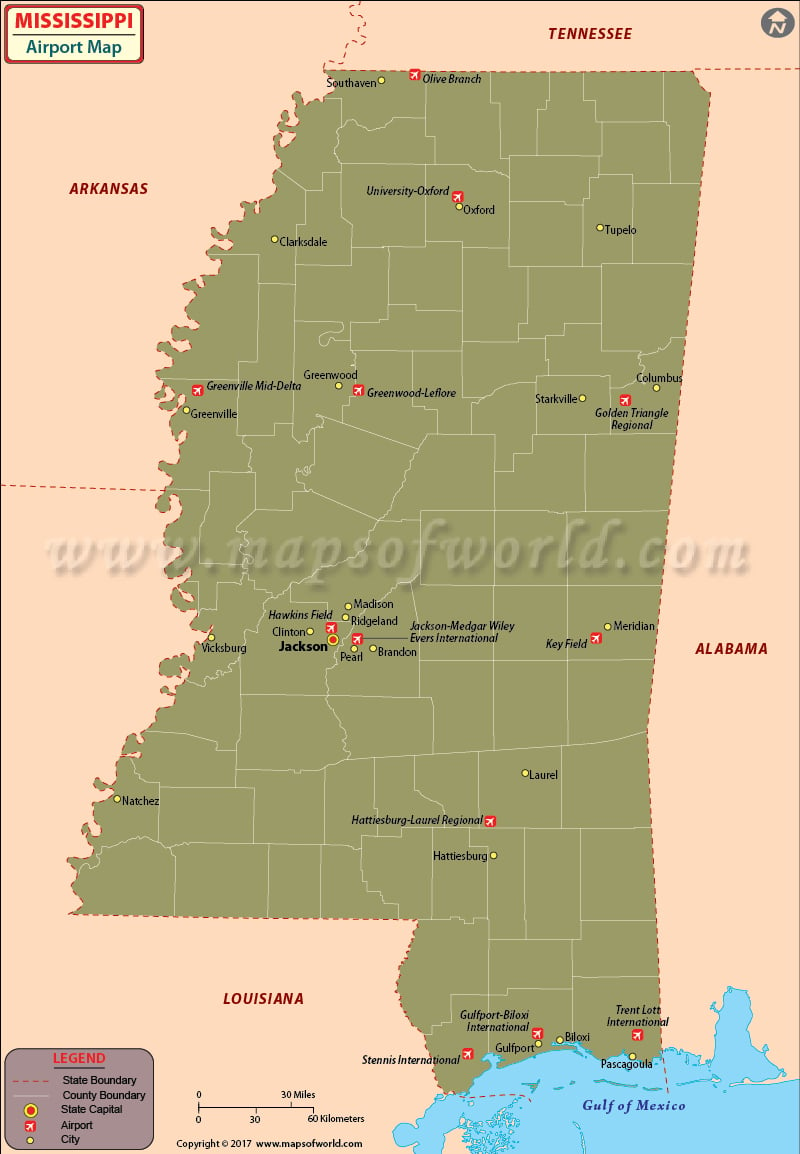
There are many airports in Mississippi for public use. The airports in Mississippi are well-connected to both US and international locations. The Mississippi airports provide both sound aviation technology and friendly service, which makes traveling there a pleasure.
The international airports in Mississippi are the Gulfport Biloxi International Airport, which serves Gulfport/Biloxi, and the Jackson Evers International Airport at Jackson. The other international airports in Mississippi are the Stennis International Airport at Bay St. Louis and the Trent Lott International Airport at Pascagoula.
The Jackson Evers International Airport at Jackson is one of the premiere airports in Mississippi. This airport receives more than 700,000 passengers every year. The airlines that operate from this airport are Delta Air Lines, American Eagle, Delta Connection, United Express and Southern Airways Express.
The Gulfport-Biloxi International Airport serves almost 500,000 people annually. The amenities available at this airport include skycap services, ATMs, meeting rooms, a news and gifts shop, award-winning eateries, a relaxing lounge, and ground transportation. The airlines that serve at this airport are American Eagle, Delta Air Lines, Delta Connection, Sun Country Airlines, and United Express.
Tickets to the above-mentioned airlines can be booked online and some airlines even offer discounts for online booking.
Other important airports in Mississippi are at Corinth, Tupelo, Greenwood, Green Ville, Columbus, Meridian, Laurel, Natchez, McComb, and Picayune.
Maps of Major Airports in Mississippi
List of Airports in Mississippi
| Airport Name | Airport Code | City | Type | Coordinates |
|---|---|---|---|---|
| Golden Triangle Regional Airport | GTR | Columbus / West Point / Starkville | Domestic | 33°26′54″N 088°35′29″W |
| Gulfport-Biloxi International Airport | GPT | Gulfport / Biloxi | International | 30°24′26″N 089°04′12″W |
| Hattiesburg-Laurel Regional Airport | PIB | Hattiesburg / Laurel | Domestic | 31°28′02″N 089°20′13″W |
| Jackson-Evers International Airport | JAN | Jackson | International | 32°18′40″N 090°04′33″W |
| Mid Delta Regional Airport | GLH | Greenville | Domestic | 33°28′58″N 090°59′08″W |
| Meridian Regional Airport (Key Field) | MEI | Meridian | Domestic | 32°19′57″N 088°45′07″W |
| Tupelo Regional Airport (C.D. Lemons Field) | TUP | Tupelo | Domestic | 34°16′05″N 088°46′12″W |
| Hernando Village Airpark | — | Hernando | — | 34°47′53″N 090°02′13″W |
| Tunica Airport | — | Tunica | — | 34°40′00″N 090°22′00″W |
 Wall Maps