South Africa
South Africa is a very popular tourist destination in Africa, and worldwide. It is a founding member of African Union, and a member of United Nations. The country is the largest economy on the continent. Once infamous for ‘Apartheid,’ South Africa is now an established democratic, multi-racial country, with people of all communities and races coexisting. South Africa is considered one of the emerging power.
Location of South Africa
Located at the southern-most region of Africa, South Africa occupies an area of 3,71,433 square miles, in the southern hemisphere. South Africa is bounded by South Atlantic Ocean in the west and south, and by the Indian Ocean in the east. The geographical coordinates of South Africa are 29.81"S and 25.34"E.
Economy and Agriculture
South Africa, is the largest economy of Africa, contributes to 24% of the continent's GDP (PPP). Post the 1994, democratic multiracial elections, the country's economic policies have been reformed with a focus on macroeconomic, creating job opportunities, and opening the markets to foreign investors.
South Africa also has a strong financial system, along with a robust energy and communication sectors. It is rich in natural resources, and the country is a member of BRICS, the joint economic group with China, Russia, India, and Brazil. South Africa's GDP in 2011 was US$422 billion. During the recent recession, South Africa suffered economically, but with the help of private and public consumption growth, the economy has recovered.
Agriculturally, South Africa is one of the world's largest producers of cereals, nuts, chicory roots, castor oil seeds, and grapefruit. Agriculture contributes to 10% of the country's GDP. Some of the major mineral and natural resources, that support South Africa's economy are, gold, diamond, platinum, and chromium.
Political History and Divisions
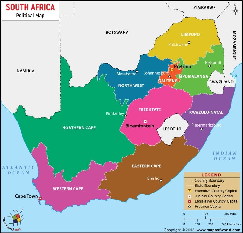
South Africa is divided into nine provinces, and has three capitals; Cape Town, Pretoria, and Bloemfontein. The South African government is a parliamentary, constitutional democratic, federal, and presidential in nature, and has three branches; the Legislature, the Executive, and the Judiciary. Each branch is housed in a different city.
The parliament of South Africa has two houses: The National Assembly, which is the lower house, and has 400 members, and the National Council of Provinces, which is the upper house, and has 90 members (10 members from each province). The President is the head of the state and the government. The responsibilities of the government are clearly defined in the constitution. South Africa has been an independent republic since 1948, but freed itself from apartheid in 1994. South Africa is a 'One party state', and post 1994 the policies of the African National Congress have determined the course of South Africa's politics.
Major Cities of South Africa
- Pretoria : 1. Pretoria is the administrative capital of South Africa, and is situated at a height of 4,363 feet (1330 m) above sea level. The geographic coordinates of the city are 25.44'S and 28.11'E. Many of streets of Pretoria are avenues lined with Jacaranda Trees; thus, locally the city is called the, ‘Jacaranda city.’
- Cape Town : 2. Cape Town is the legislative capital, and is the second most populous city in South Africa. It is South Africa's second main economic center, and a prominent tourist destination because of its agreeable climate, beautiful beaches, natural setting, and well-developed infrastructure. Its latitudinal coordinate is 33" 55' S and longitude is 18" 22' E.
- Bloemfontein : 3. It is the judicial capital, popularly known as the 'City of Roses.’ Its latitudinal extent is 27" 38' S and longitude is 25" 32' E. It is also the capital city of Free State Province.
- Johannesburg : 4. It is the largest city of South Africa, and the economic hub of the country. This city is well connected with most of the other important cities of South Africa. This city is the seat of the 'court of constitution,' where the ultimate constitutional decisions are taken.
ABOD20170728
4th century | San, Khoikhoi and Bantu tribes joined by people migrating from the north |
1652 | Dutch East India Company establishes Cape Town |
1795 | Cape Town is seized by the British colonists |
1803 | Cape Colony is returned to the Dutch |
1806 | British again gains control over Cape colony |
1816 - 1826 | Zulu empire is founded and sees rapid expansion |
1835 -1840 | Boers leave Cape Colony to establish the Orange Free State and Transvaal |
1867 | Diamond is discovered in South Africa |
1879 | British defeat the Zulus |
1880- 1881 | First Anglo-Boer War between British and Boers |
1886 | Gold is discovered |
1899 | Second Anglo-Boer War begins |
1902 | Second Anglo-British war ends and the Treaty of Vereeniging is signed |
1910 | Union of South Africa is formed by former colonies Cape, Natal, Transvaal and Orange Free State |
1912 | African National Congress formed (Formerly known as Native National Congress) |
1914 | National Party formed |
1948 | National Party, while in power, adopts the Apartheid Policy |
1961 | South Africa becomes a Republic |
1994 | First multi-racial democratic elections are held. |
Official Name | Republic of South Africa |
Capital | Pretoria (administrative Capital), Cape Town (Legislative Capita), Bloemfontein (Judicial Capital) |
Administrative Units | 9 Provinces and 3 capitals |
Houses of the Parliament (Legislative) | National Assembly (Lower House) and National Council of Provinces (Upper House). |
Type of Government | Federal republic; constitutional democracy, Parliamentary and Presidential |
Head of the State and the Government | President Jacob Zuma |
Members in National Assembly (Lower House) | 400 Members |
Members in National Council of Provinces (Upper House) | 90 Members |
Major Political Party | African National Congress |
The Provinces and Their Capitals |
---|
Province | Capital | Province | Capital |
Eastern Cape | Bhiso | Mpumalanga | Nelspruit |
Free State | Bloemfontein | North West | Mafikeng |
Gauteng | Johannesburg | Northern Cape | Kimberley |
KwaZulu- Natal | Pietermaritzburg | Western Cape | Cape Town |
Limpopo | Polokwane | | |
Province | Pop-2001 | Pop-1996 | Area(km.²) | Area(mi.²) | Capital | Former |
Eastern Cape | 6,436,761 | 6,302,525 | 169,952 | 65,619 | Bhisho | Cape of Good Hope |
Free State | 2,706,776 | 2,633,504 | 129,821 | 50,124 | Bloemfontein | Orange Free State |
Gauteng | 8,837,172 | 7,348,423 | 16,927 | 6,536 | Johannesburg | Transvaal |
KwaZulu-Natal | 9,426,019 | 8,417,021 | 92,303 | 35,638 | Pietermaritzburg | Natal, Cape of Good Hope |
Limpopo | 5,273,637 | 4,929,368 | 122,839 | 47,429 | Polokwane | Transvaal |
Mpumalanga | 3,122,994 | 2,800,711 | 79,512 | 30,700 | Nelspruit | Transvaal |
Northern Cape | 822,726 | 840,321 | 362,591 | 139,997 | Kimberley | Cape of Good Hope |
North-West | 3,669,350 | 3,354,825 | 116,180 | 44,857 | Mmabatho | Transvaal, Cape of Good Hope |
Western Cape | 4,524,335 | 3,956,875 | 129,448 | 49,980 | Cape Town | Cape of Good Hope |
9 provinces | 44,819,770 | 40,583,573 | 1,219,574 | 470,880 | | |
Note :- Pop-2001: 2001-10-10 census.
Area : Source is Municipal Demarcation Board.
Last Updated on: February 24, 2020