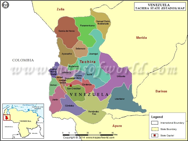
Tachira is a state in west Venezuela to the south west of the Andean Cordillera. Lying to the east of Colombia, Tachira state in Venezuela covers an area of approximately 11,100 sq. km. The geographical location of this Venezuela state is 7.51 N and 72.27 W.
Tachira climate
Tachira climate is predominantly tropical in nature. The temperature ranges between 10º C and 20º C. Since the state is in the Andean region, the temperatures are comparatively lower than the other low lying Venezuela states. Rainfall ranges between 200cm – 400cm.. Tachira in Venezuela receives considerable rain in April and November.
Tachira agriculture
Tachira is predominantly an agricultural state with coffee and sugarcane as the main cash crops cultivated here. All the industries are agriculture based and located in rural areas. Many industries are of the small scale variety in these rural locations.
Tachira tourist attractions
Tachira state is famous for its national parks. The famed national parks in Tachira in Venezuela include:
-
Chorra El Indio –
This national park in the south west region of the Andes mountains is full of rivers and creeks. This cloudy forested area has a vegetation of montane, premontane and low montane trees. The animal life is made up of False paca, peccaries, spectacled bears, and margays. Accommodation is available in the nearby villages.
-
Paramos Batallon y la Negra –
This 65,000 hectare national park is also located in the mountainous Andes region. This humid forest has a vegetation mixture of sub-Andean paramo, pluvial montane and humid montane plants. The fauna consists of spectacled bear, porcupine, mountain coati, the Andean paca, and shrew. Lodges and local houses provide accommodation to tourists traveling to this national park.
-
El Tama –
This Tachira national park is situated at the foot of the Andes south of San Cristobal. This national park on the Colombian border is noted for its sub-Alpine paramo vegetation and tropical cloud forest. Venezuelan wood quail, Rufous wren, collared inca, and sunangel are some of the beautiful birds to be observed here. Travelers can lodge in the village huts located nearby.
Municipalities of Tachira State (Estado) |
| Municipality | Capital | Population | Area(km.²) |
|---|---|---|---|
| Andrés Bello | Cordero | 16,474 | 102 |
| Antonio Rómulo Costa | Las Mesas | 7,110 | 130 |
| Ayacucho | Colón | 48,982 | 507 |
| Bolívar | San Antonio del Táchira | 48,171 | 198 |
| Cárdenas | Táriba | 94,178 | 267 |
| Córdoba | Santa Ana del Táchira | 26,475 | 618 |
| Fernández Feo | San Rafael del Piñal | 34,176 | 1,130 |
| Francisco de Miranda | San José de Bolívar | 3,632 | 280 |
| García de Hevia | La Fria | 41,863 | 911 |
| Guasimos | Palmira | 32,545 | 38 |
| Independencia | Capacho Nuevo | 29,760 | 67 |
| Jauregui | La Grita | 36,660 | 480 |
| José María Vargas | EL Cobre | 8,038 | 229 |
| Junín | Rubio | 68,869 | 326 |
| Libertad | Capacho Viejo | 23,670 | 142 |
| Libertador | Abejales | 17,744 | 1,130 |
| Lobatera | Lobatera | 10,427 | 216 |
| Michelena | Michelena | 16,269 | 113 |
| Panamericano | Coloncito | 29,594 | 569 |
| Pedro María Ureña | Ureña | 37,392 | 184 |
| Rafael Urdaneta | Delicias | 6,239 | 187 |
| Samuel Darío Maldonado | La Tendida | 13,847 | 548 |
| San Cristóbal | San Cristóbal | 250,307 | 248 |
| San Judas Tadeo | Umuquena | 6,801 | 261 |
| Seboruco | Seboruco | 9,064 | 157 |
| Simón Rodríguez | San Simón | 2,181 | 70 |
| Sucre | Queniquea | 8,189 | 407 |
| Torbes | San Josecito | 42,192 | 123 |
| Uribante | Pregonero | 21,820 | 1,462 |

 Maracaibo