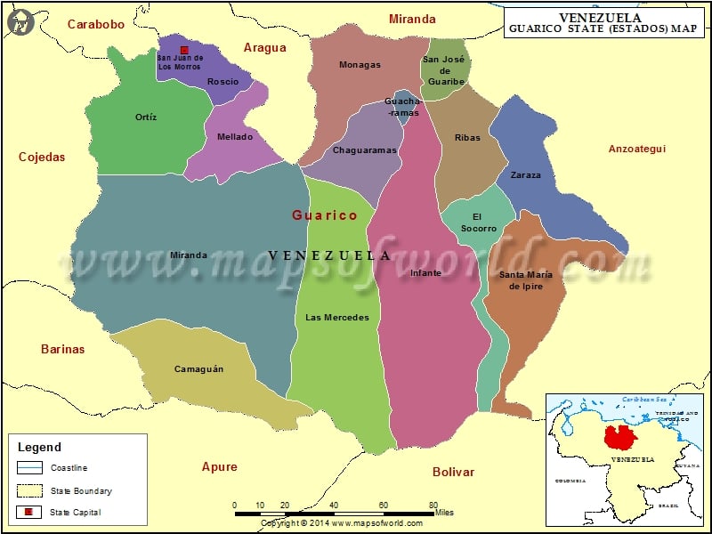
Considered to be one of the largest states in the South-American country of Venezuela, Guarico covers an area of over 64,000 square kilometers. The states of Miranda, Carabobo and Aragua bound the northern frontier of Guarico, whereas the states of Apure and Bolivar surround its southern end. San Juan of Noses acts as the capital of Guarico. Major populations of this state in Venezuela include Tucupido, Jail, Chaguaramas, Mercedes, Santa Maria de Inpire and Camaguan.
Climate of Guarico
The average annual temperature of the state of Guarico ranges between the 25º and 28º centigrade mark. This state receives an annual rainfall of approximately 1000-1500 millimeters. This state experiences a dry spell between the months of November and April. Whereas, the maximum rainfall occurs between the months of May and October.
Economy of Guarico
Agriculture contributes quite significantly to the economy of this state in Venezuela. This state has a well-developed agricultural sector comprising 16 dams and three irrigation systems. The major agricultural products include Frijol, Rice, Tobacco, Cotton, Tomato, Sorghum, Maize, Handle, Caroata and many more. This state also has petroleum, cement and natural gas industries.
Fauna of Guarico
This state is home to a variety of animals like the otters, foxes, wild cats, deer, chiguires, cachincamos, cunaguaros and many more. The reptiles include water snakes, dribbles and glapos. Birds like black birds, herons, ibises and trowels are very common in this state.
Reaching Guarico
Airport Simon Bolivar de Maiquetia lies at a distance of 163 kilometers from San Juan. Another airport Arturo Michelena Airport located in Valencia is located at a distance of 109 kilometers from Guarico.
Municipalities of Guarico State (Estado) |
| Municipality | Capital | Population | Area(km.²) |
|---|---|---|---|
| Camaguán | Camaguan | 18,041 | 1,164 |
| Chaguaramas | Chaguaramas | 10,521 | 2,069 |
| El Socorro | El Socorro | 14,049 | 2,659 |
| Francisco de Miranda | Calabozo | 118,559 | 13,490 |
| José Félix Ribas | Tucupido | 35,447 | 2,792 |
| José Tadeo Monagas | Altagracia de Orituco | 65,729 | 3,455 |
| Juan Germán Roscio | San Juan de los Morros | 103,706 | 1,497 |
| Julián Mellado | El Sombrero | 23,649 | 2,983 |
| Las Mercedes | Las Mercedes | 23,712 | 7,691 |
| Leonardo Infante | Valle De La Pascua | 101,974 | 10,613 |
| Ortíz | Ortíz | 18,377 | 4,129 |
| Pedro Zaraza | Zaraza | 54,168 | 2,410 |
| San Gerónimo de Guayabal | Guayabal | 17,753 | 4,357 |
| San José de Guaribe | San José de Guaribe | 9,998 | 1,128 |
| Santa María de Ipire | Santa Maria de Ipire | 11,402 | 4,549 |

 Maracaibo