17.1K
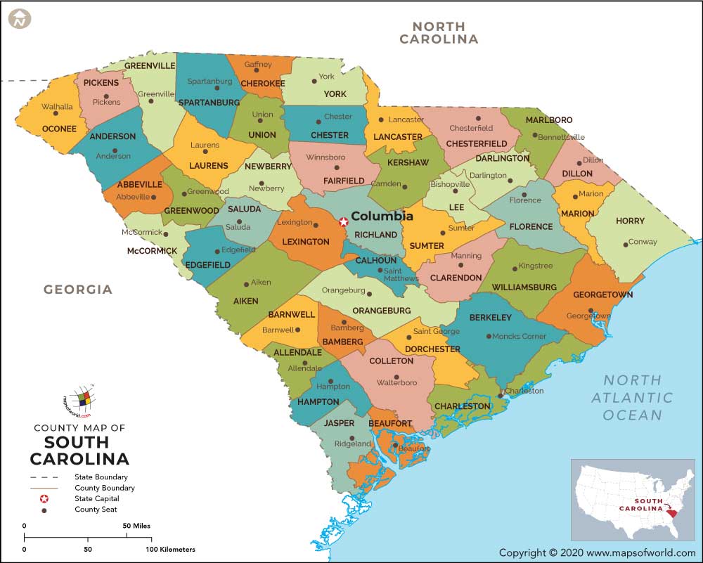
The South Carolina County Map clearly defines the administrative and political sub divisions of the state. The State of South Carolina is politically divided into 46 Counties for administrative convenience.
Each County is administered by the respective County Seats. Some of the prominent Counties of South Carolina are:
- Aiken County – Spread over 1,073 square miles, the Aiken County holds a population of 142,552 as per the census data of 2000
- Calhoun County – The Calhoun County was founded in the year of 1908. Calhoun County covers total area of 380 square miles
- Dillon County – According to census 2000, Dillon County has a population of 30,722. The County of Dillon encompasses total area of 405 square miles
- Barnwell County – The Barnwell County was founded in the year of 1798 and covers total area of 548 square miles
- Anderson County – Covering total area of 718 square miles, the Anderson County is administered by the County Seat of Anderson
- Edgefield County – Edgefield County covers total area of 502 square miles and holds a population of 24,595 as per the census statistics of 2000
The South Carolina State Map points out the exact geographical location of the 46 Counties of the state.
Maps of all counties of South Carolina
- Abbeville County Map, South Carolina
- Aiken County Map, South Carolina
- Allendale County Map, South Carolina
- Anderson County Map, South Carolina
- Bamberg County Map, South Carolina
- Barnwell County Map, South Carolina
- Beaufort County Map, South Carolina
- Berkeley County Map, South Carolina
- Calhoun County Map, South Carolina
- Charleston County Map, South Carolina
- Cherokee County Map, South Carolina
- Chester County Map, South Carolina
- Chesterfield County Map, South Carolina
- Clarendon County Map, South Carolina
- Colleton County Map, South Carolina
- Darlington County Map, South Carolina
- Dillon County Map, South Carolina
- Dorchester County Map, South Carolina
- Edgefield County Map, South Carolina
- Fairfield County Map, South Carolina
- Florence County Map, South Carolina
- Georgetown County Map, South Carolina
- Greenville County Map, South Carolina
- Greenwood County Map, South Carolina
- Hampton County Map, South Carolina
- Horry County Map, South Carolina
- Jasper County Map, South Carolina
- Kershaw County Map, South Carolina
- Lancaster County Map, South Carolina
- Laurens County Map, South Carolina
- Lee County Map, South Carolina
- Lexington County Map, South Carolina
- Marion County Map, South Carolina
- Marlboro County Map, South Carolina
- Mccormick County Map, South Carolina
- Newberry County Map, South Carolina
- Oconee County Map, South Carolina
- Orangeburg County Map, South Carolina
- Pickens County Map, South Carolina
- Richland County Map, South Carolina
- Saluda County Map, South Carolina
- Spartanburg County Map, South Carolina
- Sumter County Map, South Carolina
- Union County Map, South Carolina
- Williamsburg County Map, South Carolina
- York County Map, South Carolina
 Wall Maps