What are the Key Facts of Texas?
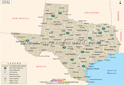
 Map of Texas which lies in the South Central region of the USA
|
State |
Texas |
|
State Capital |
Austin |
|
Largest City |
Houston |
|
Coordinates |
31°N 100°W |
|
Nickname(s) |
“The Lone Star State” |
|
Postal Abbreviation |
TX |
|
Area |
268,596 sq. mi (695,662 sq. km) |
|
Highest Point |
Guadalupe Peak, 8,751 ft (2,667.4 m) |
|
Number of Counties |
254 |
|
Neighboring States |
New Mexico, Oklahoma, Arkansas, Louisiana |
|
Population |
28,995,881 (2,019) |
|
Date of Entering the Union |
December 29, 1845 |
|
State Anthem |
“Texas, Our Texas” |
|
Governor |
Greg Abbott (Republican) |
|
Lieutenant Governor |
Dan Patrick (Republican) |
|
U.S. Senators |
John Cornyn (Republican), Ted Cruz (Republican) |
|
U.S. House Delegation |
23 Republicans, 13 Democrats |
|
GDP (Millions of Dollars) |
1918065 |
|
Demonym |
Texan, Texian (archaic), Tejano (usually only used for Hispanics) |
|
Time Zones |
Majority of state UTC−06:00 (Central), Summer (DST) UTC−05:00 (CDT); El Paso, Hudspeth, and northwestern Culberson counties UTC−07:00 (Mountain), Summer (DST) UTC−06:00 (MDT) |
Where is Texas?
Texas (the 28th state admitted to the union on December 29, 1845) is in the South Central region of the USA. Oklahoma borders it to the north, New Mexico to the west, Louisiana to the east, Arkansas to the northeast, and coastline with the Gulf of Mexico to the southeast. This state also shares its border with 4 Mexican states to the southwest, and they are Tamaulipas, Nuevo León, Coahuila, and Chihuahua.
What is the Geography of Texas?
Texas is spread across a total area of 268,596 sq. mi (695,662 sq. km), out of which 261,232 sq. mi (676,587 sq. km) is land area and 7,365 sq. mi (19,075 sq. km) is water area. Water bodies constitute 2.7% of the total area. In terms of total area, it is the 2nd largest state in the US.
The longest rivers in Texas are the Rio Grande, Red River of the South, Brazos River, Pecos River, Colorado River, Canadian River, Trinity River, Sabine River, Neches River, Nueces River, etc. The major lakes in the state are Toledo Bend Reservoir, Sam Rayburn Reservoir, Lake Livingston, Lake Texoma, Richland-Chambers Reservoir, and many more.
This state’s mean elevation is 1,700 feet (518.16 m) above sea level. While the highest elevation point in Texas is Guadalupe Peak at 8,749 feet (2,666.69 m) above sea level, the lowest elevation point is the sea level at 0 feet (0 m), where Texas meets the Gulf of Mexico. The significant mountains in the state are Guadalupe Peak, Bush Mountain, Shumard Peak, Bartlett Peak, Mount Livermore, Hunter Peak, El Capitan, Blue Mountain, Emory Peak, Lost Mine Peak, Sawtooth Mountain, and many more.
Texas has a wide geographic diversity, including forests, deserts, mountains, plateaus, plains, swamps, marshes, and rivers. There are seven main landforms in the state: Big Bend Country, Gulf Coast, Hill Country, Panhandle Plains, Piney Woods, Prairies and Lakes, and South Texas Plains.
One of the most critical landforms in Texas is Big Bend Country, which is in the western region of the state. The landmass is predominantly a desert area that is full of plateaus and mountains. This land is the only Texan region where mountains are found in the state. This area spreads across a total area of 38,000 sq mi (98,419.55 sq km). The Rio Grande River runs across this region, and many canyons travel along the river.
While the deserts in this area experience dry and hot conditions, the mountains in this region experience a cold and snowy climate. Big Bend’s elevation ranges from 2,500 feet (762 m) to 8,749 feet (2,666.69 m). This landform has the highest elevation point in Texas. Rugged plateaus having very short grasses are there in the dry and open areas.
The second prominent landform is the Gulf Coast, which houses some of the most important cities in Texas such as Houston, Galveston, and Corpus Christi. This landform is spread across a total area of around 13,900 sq mi (36,000.84 sq km) and is on the eastern coast of Texas. The major rivers in this region run through multiple cities including, San Jacinto, San Antonio, Nueces, Brazos, and Trinity. This region also houses multiple streams, salt grass marshes, and estuaries
Grasslands and prairies are located mainly in the western part of the Gulf Coast. It receives around 40-60 inches of rain every year.
The Texas Hill Country is in the central part of Texas. This landform is characterized by hilly grassland, and one of the significant components of Hill Country is San Marcos Springs. While the total area of Edwards Plateau is 31,000 sq mi (80,289.63 sq km), the average rainfall in this region is 15-34 inches (381-863.6) per year.
The Panhandle Plains, a landform in the northern part of Texas, consists mainly of flat and grassy lands with either no trees or a few numbers of trees. It spreads across a total area of 81,500 sq mi (211,084.03 sq km). The eastern part of the region receives more rainfall than the western part. Two main canyons in the Panhandle-Plains are Palo Duro Canyon and Caprock Canyon State Parks. Five rivers flow through this region, and they are Brazos, Colorado, Canadian, Red, and Pecos.
The fifth most important region in the state is Piney Woods. Woodlands and vast forest areas are the most characteristic features of this region. The average elevation of the region is low, with the predominance of hardwood trees, wetlands, and swamps. Piney Woods spreads across a total area of 23,500 sq mi (60,864 sq km). The main rivers that run through this landform are Red Rivers, Sulpher, Cypress, and Sabine. It receives an average annual rainfall of around 40-52 inches (1,016-1,320.8 mm).
The Prairies and Lakes region are one of the essential terrain types present in Texas, which spreads across a total area of 45,000 sq mi (116,549.46 sq km). They are in the northern and central regions of Texas. The area is full of woodlands as you run from north to south. Spaces full of trees interrupt the grasslands occasionally in the prairies and lakes region. Some of the most popular state parks in such as Cedar Hill State Park, Lake Ray Roberts, and Lake Fork.
The South Texas plain is the seventh most crucial land area in Texas, which is in the Rio Grande Valley’s subtropical regions. This landform, which spreads across a total area of 28,000 sq mi (72,519.67 sq km), is characterized by thorny bushes, grasses, marshes, and ponds. The major rivers that run through this region are the Rio Grande River, Lavaca River, Nueces River, San Antonio River, and Guadalupe River.
National Parks in Texas
There are different national parks and other national sites located in the state of Texas. Fort Davis National Historic Site is famous for the Buffalo Soldiers (all-black regiments) who were stationed at Fort Davis from 1867 to 1885. Big Thicket National Preserve is another important site, with a rare reserve of flatland palmetto hardwoods, Savannah, floodplain forests, mixed hardwood, and pine forests. Check this National Parks in Texas Map locating all the national parks in the US.
What is the Climate of Texas?
Texas has a diverse climate, thanks to the large area it spreads across and its varied landforms. While the western part of the state is arid and semi-arid, the eastern part is predominantly humid and subtropical. Multifarious weather patterns are created on the vast expanse of the state in accordance with the location and land region (such as coastal region, south, east, west, north, and northern panhandle).
In the northern part of the state, the climate remains semi-arid, and the yearly average precipitation revolves around 18-20 inches (457.2-508 mm). The north panhandle region is the coldest in Texas, and the annual snowfall level revolves around 25-30 inches (635-762 mm). While winters remain cold, the summer season remains hot with clear skies and abundant sunshine.
Arid and temperate climate patterns are found in the Big Bend Country region. The arid areas, including Big Bend Country, receive around 15 inches (381 mm) of annual precipitation. Heavy snowfall takes place in the mountains. The season of summer remains dry. The sky remains clear during the rest of the year.
The central parts of the state’s climatic condition range from a semi-arid climate in the western region to subtropical in the other sections. While winters are mild here, the summer season remains hot and humid. The yearly average rainfall ranges from 21 inches (533.4mm) in the western part of the region to 35 inches (889mm) in the other parts of the area.
The humid subtropical zone prevails in the eastern part of the state. The yearly rainfall level revolves around 60 inches (1,524 mm). Maximum rainfall takes place during 3-months of the year (April, May, and June). It remains mostly cloudy across the year near the coastal areas.
During spring (April and May) and early summer seasons, severe thunderstorms, tornadoes, and hurricanes occur. While the eastern part gets hot and humid in summer, the Gulf of Mexico area remains comparatively more relaxed. A moderate temperature is found in the southern parts (along the coastal belt) of Texas. South gets a hot and dry summer season, and snowfall is rare. While coastal areas get abundant rainfall, inland ranch-type areas get a semi-arid climate. As you move inland, the climatic condition remains very similar to that of the Northern Plains.
What is the Economy of Texas?
Texas is the 2nd biggest economy in the US, in terms of Gross State Product (GSP), and its GSP is higher than the country with the 10th largest GDP in the world. The total GDP of the state has increased from US$1,237,394.9 million in 2008 to US$1,802,511.2 million in 2018.
The Per Capita Personal Income in Texas has increased from US$36,711 in 2009 to US$52,504 in 2019, while the Real Median Household Income has increased from US$54,343 in 2008 to US$59,785 in 2018.
Data available from the US Energy Information Administration says that the state produced around 37% of the total crude oil production of the US in 2017.
Agriculture forms an integral part of the economy. It ranks #1 and #2 in total livestock/livestock product receipts and total agricultural receipts, respectively. The leading agricultural products (in terms of revenue) of the state are beef cattle & calves, cotton, broilers, greenhouse, nursery products, and dairy products. The major industries in Texas are petroleum and natural gas, banking, steel, farming, and tourism.
Texas is the leading manufacturing state in the US. The major manufacturing industries in the state are computers and electronic equipment, chemicals, the food processing sector, and many more. Besides oil and natural gas, other significant mining sector includes cement, gravel, silt, sand, lime, crushed stone, and others.
The unemployment level in Texas before the 2007-2008 economic crisis was around 4.2% (May 2007). However, it progressively grew to 8.3% (August 2009) within two years. However, continued growth has decreased the unemployment rate to just 3.5% in January 2020.
The poverty rate in the state was 14.9% in 2019. The total number of poor people in Texas was 4,180,675 out of a total population of 28,074,573.
What is the Transportation System of Texas?
Texas has an extensive transportation system, including highways, railroads, airports, mass transportation, ports, etc. The operation and maintenance of the state highways are done by The Texas Department of Transportation (TxDOT). The most extensive state highway system in the United States is present in Texas.
There are 3,233.4 miles (5,203.7 km) of Interstate Highway System in Texas, and the most important ones are I-10, I-20, I-35, I-45, I-30, I-40, I-37, I-27, I-35E, I-35W, I-69, I-69E, and many more. The most critical US Highways in the state are US 83, US 87, US 67, US 59, US 90, US 281, US 84, US 190, US 82, US 287, etc.
There is an extensive state highway system across Texas. SH 16 is the longest state highway in the state. Some other essential state highways are SH 6, SH 36, SH 70, SH 21, SH 71, SH 87, SH 7, SH 35, SH 163, SH 207, SH 349, and many more.
Texas has 730 airports. The major ones are Dallas/Fort Worth International Airport (in Dallas), George Bush Intercontinental Airport (in Houston), Dallas Love Field (in Dallas), William P. Hobby Airport (in Houston), Austin-Bergstrom International Airport (in Austin), San Antonio International Airport (in San Antonio), El Paso International Airport (in El Paso), Midland International Airport (in Midland), Lubbock Preston Smith International Airport (in Lubbock), McAllen Miller International Airport (McAllen), Rick Husband Amarillo International Airport (in Amarillo), Corpus Christi International Airport (in Corpus Christi), Valley International Airport (in Harlingen), Killeen-Fort Hood Regional Airport / Robert Gray Army Airfield (in Killeen), Brownsville/South Padre Island International Airport (in Brownsville), Laredo International Airport (in Laredo), Abilene Regional Airport (Abilene), Easterwood Airport (Easterwood Field) (College Station), Waco Regional Airport (in Waco), San Angelo Regional Airport (Mathis Field) (San Angelo), Wichita Falls Municipal Airport / Sheppard Air Force Base (in Wichita Falls), Tyler Pounds Regional Airport (in Tyler), Biggs Army Airfield (in Fort Bliss / El Paso), Jack Brooks Regional Airport (in Beaumont), East Texas Regional Airport (in Longview), and many more.
There are around 1,150 ports in Texas. The most important ones (in terms of total trade) are the Port of Houston, Port of Beaumont, Port of Corpus Christi, Port of Texas City, Port of Port Arthur, Port of Freeport, Port of Galveston, Port of Port Lavaca – Point Comfort, Port of Brownsville, Port of Victoria, and many more.
What is the origin of the name “Texas”?
The word Texas is derived from the word “teysha,” which means “hello friend” as per the Caddo Indian tribe’s language. The tribes living in Texas, Oklahoma, and Louisiana were friendly. That’s why the Spanish explorers and settlers used to call these tribes by this name.
Why Texas is called the “Lone Star State”?
“The Lone Star State” is the official nickname of Texas, which was officially adopted when Governor Greg Abbott signed House Concurrent Resolution No. 78, 84th Legislature, Regular Session, on June 19, 2015.
Texas got this nickname from the symbolism of the star on the 1836 National Standard of Texas flag of the republic. The Lone Star includes a single gold star on a blue background, signifying the independence of Texas from Mexico. The Lone Star has become the sign of an independent republic, and that’s why it is also found on the Texas State Flag as well as Texas State Seal. That’s why Texas is also known as “The Lone Star State”.
Other popular nicknames of Texas are “The Beef State”, “The Banner State”, “The Blizzard State”, “The Jumbo State”, and many more.
What are the Popular Tourist Attractions in Texas?
The most popular tourist destinations in the state are San Antonio’s River Walk, The Alamo, Space Center Houston, Big Bend National Park, Padre Island National Seashore, The Texas State Capitol (in Austin), The Sixth Floor Museum (Dallas), Guadalupe Mountains National Park, The Fort Worth Stockyards, Galveston’s Beaches & Strand Historic District, The USS Lexington, Corpus Christi, Cadillac Ranch, Amarillo, Natural Bridge Caverns, Houston’s Museum District, Gruene Historic District, New Braunfels, and many more.
Facts About Texas
1) Texas, the constituent part of the U.S., became the 28th state of the union in the year 1845.
2) It is the second most populous (after California) as well as the second biggest state (after Alaska) out of the 50 states that make up the United States of America.
3) Texas is situated in the south-central region of the country and to the south shares an international borderline with the Mexican states of Coahuila, Tamaulipas, Chihuahua, and Nuevo Leon.
4) Texas also borders Louisiana to the east, New Mexico to the west, Arkansas to the northeast, and Oklahoma to the north.
5) The state approximately spans an area of 266,833 square miles with an increasing population of more than 26.9 million people, according to a July 2014 estimate.
6) Houston – the largest city in Texas – is also the fourth-biggest city in the U.S.
7) The nickname Lone Star State signifies Texas as a former sovereign republic – it serves as a reminder of the state’s independence struggle from Mexico.
8) Texas is derived from the word – Tejas, which stands for ‘friends’ in the Caddo language.
9) Guadalupe is the highest peak in Texas which rises to 2,667 meters above sea level.
10) The slogan “Six Flags over Texas” signifies the six nations that held sway over the territory of Texas.
11) Possessing an abundance of natural wealth, Texas is a chief agricultural state and a major industrial hub. Chief manufacturing industries of Texas comprise oil refining, chemicals, food processing, transport equipment, and machinery.
12) Having a vast expanse of high prairie, it is a leading state in such categories as sheep, cattle, oil, and cotton. Other precious resources of Texas include helium, sulfur, salt, natural gas, clays, bromine, and cement.
13) Rio Grande is a major river in Texas that covers some 1,900 miles from the point of its origin in the Rocky Mountains, Colorado to the Gulf of Mexico. Other important rivers are Brazos, Trinity, Sabine, and Red rivers.
14) More than $50 billion is annually spent by millions of visitors to above 100 state parks, recreation zones, and other places of interest, such as the Lyndon B. Johnson Space Center in Houston, the Gulf Coast resort region, the Big Bend, the Alamo of San Antonio, and Guadalupe Mountains National Park.
15) Texas is home to a wide range of insects and animals – having 590 native species from the prodigious bird life diversity of the United States, 213 species of amphibians and reptiles, and 65 species of mammals.
16) Texas, as an independent nation, would rank as the seventh-biggest producer of greenhouse gases in the world – emitting about 1.5 trillion pounds of Carbon dioxide every year. The reasons for the state’s vast emissions of greenhouse gas are attributable to the state’s manufacturing and refining industries and mega coal power plants.
17) The most horrendous natural calamity in the U.S. occurred in Galveston, the island city of Texas, which was once the country’s largest cotton port and a significant gateway for emigrants. A Category 4 typhoon on 8 September 1900 completely ruined the city and killed as many as 12,000 people.
18) The first governor and first president of Texas were Sam Houston, whose statue called A Tribute to Courage is the largest freestanding statue of an American in the world.
19) The Texas Star in the Dallas State Fair Park is the biggest ferry wheel in the Western Hemisphere.
20) The oldest and the largest rattlesnake roundup in the world is held in Sweetwater, Texas, every year in the month of March.
Related Links: