
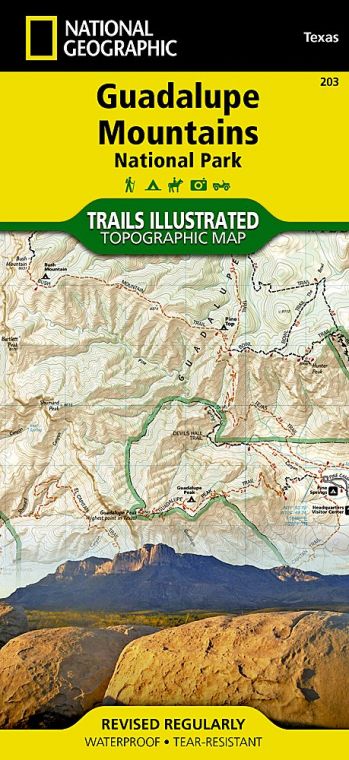
Guadalupe Peak, at 8,751 feet, ranks as Texas’ high point, and the strenuous hike to its summit has long been among the park’s most popular activities. But the park’s true icon is El Capitan, the imposing limestone bluff that stands at the southern tip of the Guadalupe Mountains.
Buy for $14.95
Established in 1972 at the height of the push for wilderness protection in the United States, Guadalupe Mountains National Park maintains that ethic, with developed areas covering only a small part of its 135 square miles. No roads reach the high country, so experiencing much more than just its edges requires ascending 2,000 feet or more by trail. Still, there’s plenty to see here with only moderate exertion.
How to Visit
On a day trip, stop at the Pine Springs Visitor Center not only to learn about the park’s geology, wildlife, and recreational opportunities but also to understand the challenges of hiking here. Trails to the high country are steep and rocky, making them more difficult than their mileage might indicate. There’s no water available anywhere in the Guadalupe uplands. Combine that with sun, heat, and moisture-sapping wind, and dehydration and fatigue can be serious problems. Carrying enough water is the most important single factor for safe and enjoyable hiking in the park. Many Guadalupe Mountains rangers are strong advocates of the use of trekking poles in the park. Most injuries occur during descents on steep trails when hikers lose their balance on loose rock.
Caveats aside, hundreds of visitors a year spend a day climbing Guadalupe Peak and are rewarded with the satisfaction of reaching the highest mountain in Texas, and (on clear days) with a panoramic vista. Other favorite destinations in the high country include The Bowl, known for its wildlife, and El Capitan.
Far less strenuous is the hike up McKittrick Canyon, always ranked among the most popular and beautiful walks in Texas. McKittrick is famed for the fall foliage of its maples and oaks and is often crowded at that season.
O n a second day, you can visit the often overlooked Dog Canyon, on the park’s northern edge, offering an alternative route to the Guadalupe Mountains high country, or the Salt Basin Dunes area, in the park’s western section—new facilities make a trip to this unique landscape much easier than in previous years (see p. 178).
Useful Information
How to get there
From El Paso, TX (about 100 miles west), take U.S. 62/180 east to the park visitor center. From Carlsbad, NM (about 50 miles northeast), take U.S. 62/180 west. The closest gas station to the park is 32 miles from the visitor center.
When to go
Fall is the best time for hiking and enjoying colorful foliage. The park is often crowded then, as well as during spring break. May and June are very hot in the lowlands; late-summer rains provide some relief. In winter, the high country can see cold temperatures and occasional snow.
Visitor Center
The Pine Springs Visitor Center is located on U.S. 62/180. There’s a ranger station at Dog Canyon, in the northern part of the park.
Headquarters
400 Pine Canyon Dr. Salt Flat, TX 79847 nps.gov/gumo 915-828-3251
Camping
Developed campgrounds are located at Pine Springs (39 sites) and Dog Canyon (13 sites). Backpackers must obtain a free permit at the Pine Springs Visitor Center or the Dog Canyon Ranger Station.
Lodging
A variety of lodgings can be found in Whites City, NM, and Carlsbad, NM (carlsbadchamber.com).
US National Parks Map
About the Guide
