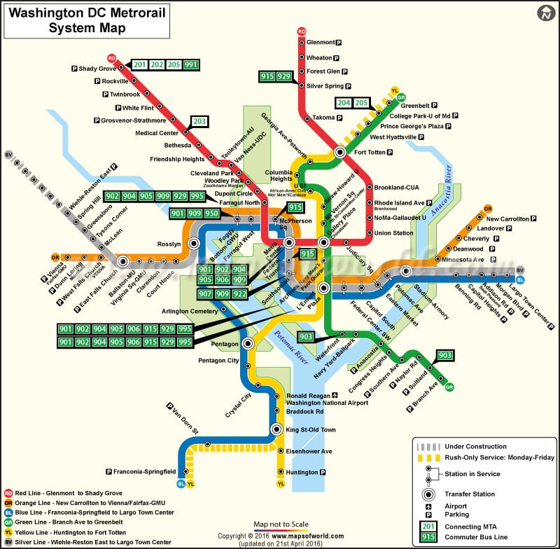
About Washington DC Metro Rail Network
Washington DC Metro is one of the fastest and easiest means of transportation in the city. There is a Washington DC Metro Schedule that is followed in the city. There are separate schedules for weekdays and weekends as well as for holidays.
The hours of Metro Rail operation also change for weekdays and weekends and specific holidays. During the peak hours of service, the schedules are so busy that it is extremely difficult to maintain a timetable.
Washington DC Metro Hours
Open: At 5.00 am on Weekdays
At 7.00 am on Weekdays
Close: 12.00 am(Midnight) on Sunday to Thursday, and 3 am Friday and Saturday nights.
Most crowded times are 7:45 to 8:45 am and 4:45 to 5:45 pm
Washington DC Metro Rail Routes
Red Line: Glenmont to Shady Grove
Orange Line: New Carrolton to Vienna/Fairfax-GMU
Blue Line: Franconia-Springfield to Largo Town Center
Green Line: Branch Avenue to Greenbelt
Yellow Line: Huntington to Fort Totten
Silver Line: Wiehle-Reston East to Largo Town Center.
Washington DC Metro Rail Network
Shady Groove to Glenmont:
Shady Groove, Rockville, Twin brook, White Flint, Grosvenor, Medical Center, Bethesda, Friendship Heights, Tenleytown-AU, Van Ness-UDC, Cleveland Park, Woodley Park-Zoo Adams Morgan, Dupont Circle, Farragat North, Gallery Pl.-Chinatown, Union Station, New York Ave. (planned), Rhode island, Brookland-CUA, Takoma, Silver Spring, Forest Glen, Wheaton, Glenmont.
Addison Rd. to Franconia-springfield:
Addison Rd., Capital Heights, Benning Rd., Potomac Ave., Eastern Market, Capital South, Federal Center SW, Smithsonian, Federal Triangle, McPherson Square, Farragat West, Foggy Bottom-GWU, Arlington Cementry, Pentagon City, Crystal City, National Airport, Braddock Road, King St., Van Dorn Street, Franconia Springfield.
Vienna/Fairfax-gmu to New Carrollton:
Vienna/Fairfax-GMU, Dunn Loring – Merrifield, West Falls Church-VT/UVA, West Falls Church, Ballston-MU, Virginia Sq.-GMU, Clarendon, Court House, Foggy Bottom-GWU, Farragat West, McPherson Square, Federal Triangle, Smithsonian, Federal Center SW, Capital South, Eastern Market, Potomac Ave., Minnesota Ave., Dean wood, Cheverly, Landover, New Carrollton.
Mount Vernon Sq. to Huntington:
Mount Vernon Sq., Archives Navy Mem., Pentagon City, Crystal City, National Airport, Braddock Road, King St., Eisenhower Avenue, Huntington.
Greenbelt to Branch Ave.:
Greenbelt, College Park-U of MD, Prinz George’s Plaza, West Hyattsville, Fort Totten, Georgis Ave. Petworth, Columbia Height, U St.-Cardozo, Shaw-Howard University, Mt. Vernon Sq., Gallery Chinatown, Archives-Navy Mem., Waterfront, Navy Yard, Anacostia, Congress Heights, Southern Ave., Naylor Rd., Suitland, Branch Ave..
Transfer Station:
Fort Totten, Metro Center, Rosslyn, Gallery Pl.-Chinatown, L’ Enfant Plaza, Stadium-Armory, Pentagon.
Washington DC Metro Rail Infomation
| Line name | Stops | Conneting MTA | Commuter Bus Line |
|---|---|---|---|
| Red Line | Sandy Grove | 201, 202, 205 | 991 |
| Red Line | Medical Center | 203 | NA |
| Red Line | Silver Spring | NA | 915, 929 |
| Red Line | Farragut North | NA | 902, 904, 905, 909, 929, 995 |
| Red Line | Metro Center | NA | 901, 902, 904, 905, 906, 909 |
| Orange Line | Foggy Bottam GWU | NA | 901, 909, 950 |
| Orange Line / Blue Line | Mc Pherson Sq | NA | 915 |
| Orange Line / Blue Line | Federal Triangle | NA | 915 |
| Orange Line / Blue Line | Smithsonian | NA | 907, 909, 922 |
| Green Line | Suitland | NA | 903 |
| Green Line | Waterfront-SEU | NA | 903 |
| Green Line | College Park-U of Md | 204, 205 | NA |
| Yellow Line | L’ Enfant Plaza | NA | 901, 902, 904, 905, 906, 915, 929, 995 |
| Yellow Line | Archives- Navy Mem’l Penn Quarter | NA | 901, 902, 904, 905, 906, 915, 929, 995 |
