Sri Lanka Map
- Sri Lanka Provinces - Central, Eastern, North Central, North Western, Northern, Sabaragamuwa, Southern, Uva, Western
- Neighboring Countries - India
- Continent And Regions - Asia Map
- Other Sri Lanka Maps - Where is Sri Lanka, Sri Lanka Blank Map, Sri Lanka Road Map, Sri Lanka Rail Map, Sri Lanka River Map, Sri Lanka Cities Map, Sri Lanka Political Map, Sri Lanka Physical Map, Sri Lanka Flag
About Sri Lanka
Explore this Sri Lanka map to learn everything you want to know about this country. Learn about Sri Lanka location on the world map, official symbol, flag, geography, climate, postal/area/zip codes, time zones, etc. Check out Sri Lanka history, significant states, provinces/districts, & cities, most popular travel destinations and attractions, the capital city’s location, facts and trivia, and many more.
| Official Name | Sri Lanka Prajatantrika Samajavadi Janarajaya (Sinhala); Ilangai Jananayaka Socialisa Kudiarasu (Tamil) (Democratic Socialist Republic of Sri Lanka) |
| Capital | Sri Jayawardenapura-Kotte |
| Population | 19,399,000 (2001) |
| Area | 65,610 sq km or 25,332 sq mi |
| Currency | Sri Lanka Rupee (US $1=90.15) |
| Religion | Buddhism, Hinduism, Islam, Christianity |
| Literacy | 88% |
| Languages | Sinhala and Tamil (official) |
| Major Cities | Colombo, Kandy, Jaffna, Galle |
| Climate | Tropical in nature |
Couched in the azure waters of the Indian Ocean, Sri Lanka has attracted traders and travelers for centuries. A languorous tropical isle of deep spirituality and serenity, Sri Lanka entered the Western imagination as the Tahiti of the East.
Despite its smallness, it has garnered a plethora of names-Serendib, Ceylon, Teardrop of India, Resplendent Isle, Island of Dharma, and Pearl of the Orient-an accumulation that reveals its richness and beauty, and the intensity of affection that it has evoked in visitors.
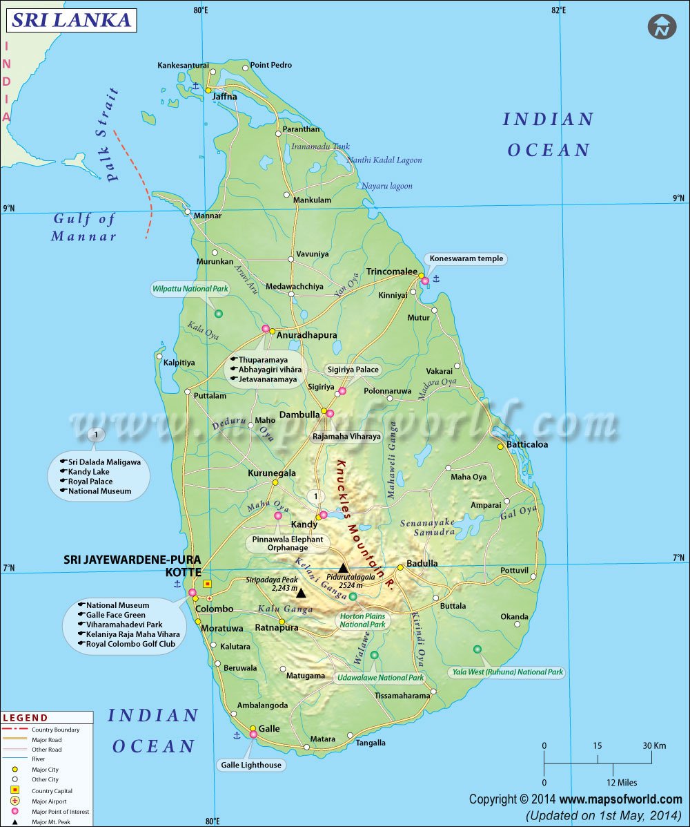
Location of Sri Lanka
Sri Lanka, an island in the Indian Ocean, is located to the south of the Indian subcontinent. It lies between 5°55′ and 9°55′ north of the equator and between the eastern longitudes 79°42′ and 81°52′. Sri Lanka is shaped like a giant teardrop falling from the southern tip of the vast Indian subcontinent. It is separated from India by the 50-km-wide Palk Strait, although there is a series of stepping-stone coral islets known as Adam’s Bridge that almost form a land bridge between the two countries
Physical Map of Sri Lanka
With a length of 445 km and breadth of 225 km, Sri Lanka encompasses beautiful tropical beaches, verdant vegetation, ancient monuments and a thousand delights to please all tastes. The relief features of the island consist of a mountainous mass somewhat south of the center with heights exceeding 2,500 m surrounded by broad plains. Palm-fringed beaches surround the island.
The southern half of the island is dominated by beautiful and rugged hill country. The entire northern half comprises a large plain extending from the edge of the hill country to the Jaffna peninsula. The highest mountain is the 2524-m-high Mt Pidurutalagala (near Nuwara Eliya) and the longest river is the Mahaweli that courses from the center and empties into the Indian Ocean at Trincomalee. The best beaches are on the southwestern, southern and southeastern coasts.
Climate of Sri Lanka
In the lowlands, the climate is typically tropical with an average temperature of 27°C in Colombo. In the higher elevations, it can be quite cool with temperatures going down to 16°C at an altitude of nearly 2,000 m. Bright, sunny warm days are the rule and are common even during the height of the monsoon-climatically Sri Lanka has no off-season. The southwest monsoon brings rain mainly from May to July to the western, southern and central regions of the island, while the northeast monsoon rain occur in the northern and eastern regions in December and January.
Flora And Fauna of Sri Lanka
The abundance of Sri Lanka’s bird life makes it an ornithologist’s paradise. Of the recorded 431 species, 251 are resident and no less than 21 are endemic to the island. Of the 242 known species of butterflies, most are found in the regions of the lower foothills (up to 910 m). A few (six species) can be glimpsed above 1210 m.
Of the 86 species of mammals, the pride of place goes to the majestic elephant. Other mammals include the sloth bear, the protected dugong, the wild boar, the porcupine and monkeys, especially the gray langur, which is common throughout the island. Of special interest is the endemic purple-faced leaf monkey, found in the higher hill regions. The island abounds in reptiles of which 75 are endemic. Of the two endemic species of crocodile, the commonest is the marsh crocodile. The beautiful star tortoise is the only land tortoise. Besides, there are five species of turtles, all protected by law. Of the 83 species of snakes, only five are lethal, these being cobra, Russell’s viper, Indian krait, Ceylon krait, and the saw-scaled viper.
The diversified climate allows for trees, tropical as well as temperate. The luxuriant undergrowth and tall majestic trees of the wet-zone tropical forests contrast with the arid scrubland and tall palms of the north and east. In the hills, vegetation varies from the almost treeless patanas-Moon Plains, Elk Plains, etc.-to the dark rhododendron forests, wreathed with the protected sphagnum moss, to the gorse covered Horton Plains. From March to May numerous flowering trees such as the fiery Poinciana regia, the white Mesua ferrea, and the cherry blossom-like tabebuia burst into bloom. Flowering orchids include endemic varieties such as the protected daffodil and wesak orchids.
People of Sri Lanka
Sri Lanka has a population of 18.5 million of whom the majority are Sinhalese (74%). Other ethnic groups are made up of Sri Lankan Tamils (12.6%), Indian Tamils (5.5%), Moors, Malays, Burghers (of Portuguese and Dutch descent) and others (7.9%). Although Sri Lanka is a multi-religious country, Buddhists constitute the majority with 69.3%. Other religious groups are Hindus 15.5%, Muslims 7.6% and Christians 7.5%. Sri Lanka’s literacy rate of 88.6% is one of the highest in Asia. Sinhala and Tamil are official languages in Sri Lanka. Sinhala, a language of Indo-Aryan origin is the language of the majority. English is widely spoken and understood. Place names and signboards on buses and trains are usually in all three languages.
Flag of Sri Lanka
The flag of Sri Lanka is yellow with two panels. The smaller hoist-side panel has two equal vertical bands of green (hoist side) and orange; the other panel is a large dark red rectangle with a yellow lion holding a sword, and there is a yellow bo leaf in each corner; the yellow field appears as a border around the entire flag and extends between the two panels.
Arts, Culture and Music of Sri Lanka
Woodcarving, weaving, pottery and metalwork are all highly developed crafts, and Sri Lanka is especially renowned for its gems. Ambalangoda is the best place to see Sri Lankan masks; Ratnapura is the center of Sri Lanka’s gem trade.
Sri Lanka’s classical architecture, sculpture and painting are predominantly Buddhist. Stupas sprinkle the countryside, and there are several extravagantly large Buddha sculptures, notably at Aukana and Buduruvagala. Anuradhapura and Polonnaruwa have the most impressive archaeological legacy, but Kandy is the most thriving cultural center today. Colonial remnants include Dutch forts, canal and churches and British residences, clubs and courthouses. Galle is the finest colonial city on the island.
Sinhalese dancing is similar to Indian dance but relies on acrobatics, nimbleness and symbolism to unfold its narratives. Kandy is a good place to see ‘up-country dancing,’ but Colombo or Ambalangoda are the places to witness the ritualistic exorcism of ‘devil dancing.’ Folk theatre combines dance, masked drama, and drumming and exorcism rituals to vividly recreate Sri Lankan folklore.
Sri Lanka is mainly an agrarian country. The chief crop is rice with which the country is almost self-sufficient. Tea, rubber and coconut are also important agricultural crops, with tea being a major foreign exchange earner. In addition, other crops of importance are cocoa and spices such as cinnamon, cardamom, nutmeg, pepper and cloves. Fruit and vegetables, native to both tropical and temperate regions, grow well in Sri Lanka. Sri Lanka is also a major exporter of precious and semi-precious stones. Within the last few years, remittances from Sri Lankans employed abroad have contributed a large share towards foreign exchange.
The last three decades have seen tourism emerge as an important industry. There has also been a rapid growth in manufacturing industries, which offer a wide range of export goods such as petroleum products, leather goods, ready-made garments and electronic equipment.
Sri Lanka History
Sri Lanka History is really ancient, covering nearly 2,500 years and full of many notable happenings and incidents. The main episodes of Sri Lanka History has been documented in various chronicles, with the most important one in Pali language.
Sri Lanka History Facts:
Sri Lanka History and culture has been noted in the Indian epic called Ramayana, where the country is referred to as the “resplendent land”. Sri Lanka History claims to be extremely rich and the country is a composite of multiple ethnic races and groups. The Indo-Aryan race from India forms the biggest group. Sri Lanka was known as Ceylon till 1972, when it was a colony of the British.
Sri Lanka Politics
Sri Lanka politics might seem to be as complicated as any other political body or organization, but it is rest assured that Sri Lanka politics too is concerned with the welfare of the people and the country.Sri Lanka politicsdeals with the Sri Lanka Elections, the Sri Lanka Government, Sri Lanka law and order or the military, Sri Lanka Foreign Relations etc.
politics of Sri Lanka is democratic in nature, where the President of Sri Lanka is both the head of state and the head of the government. The Government administers the executive power and the legislative power goes to both the parliament and the government for administration. The executive branch consist of the president and the prime minister and the legislative branch consist of the Parliament.
The two major political parties in Sri Lanka are The United National Party and The Sri Lanka Freedom Party. Both of these parties abide by the democratic values. They also approve of International Non-Alignment and encourage the development of the indigenous Sinhalese culture.
Sri Lanka politics has the following administrative divisions:
- Civil Service Structure
- Provincial Council Structure
- Local Government Structure
Sri Lanka politics, altogether is meant for maintaining law and order of the country and imbibe a peaceful living.
