9.5K
- Neighboring Countries - Bangladesh, Nepal, Myanmar, India, China
- Continent And Regions - Asia Map
- Other Bhutan Maps - Bhutan Map, Where is Bhutan, Bhutan Blank Map, Bhutan Road Map, Bhutan River Map, Bhutan Cities Map, Bhutan Physical Map, Bhutan Flag
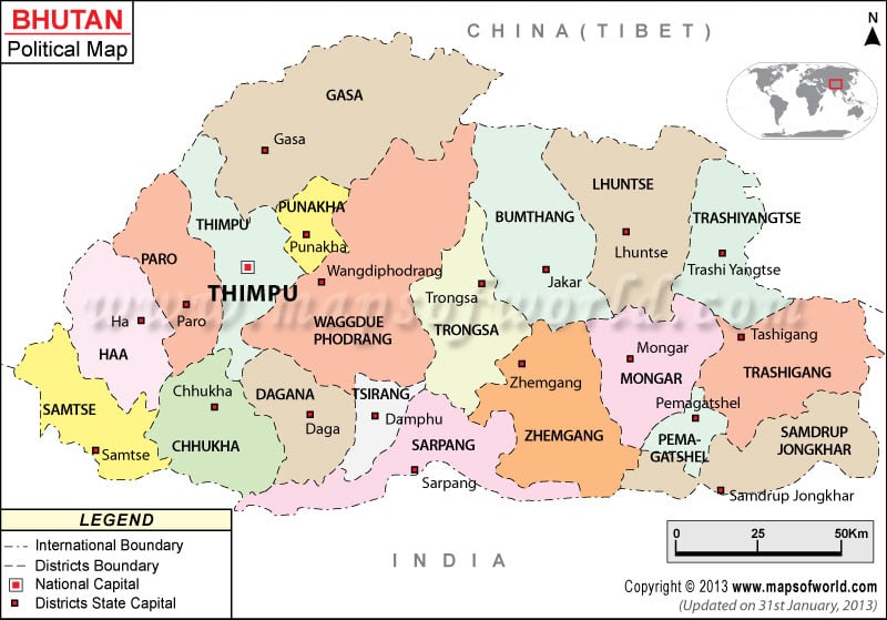
Districts in Bhutan |
|---|
| District | Population | Area(km.²) | Area(mi.²) | Capital |
|---|---|---|---|---|
| Bumthang | 16,116 | 2,831 | 1,093 | Jakar |
| Chhukha | 74,387 | 1,791 | 692 | Chhukha |
| Chirang | 18,667 | 641 | 247 | Damphu |
| Daga | 18,222 | 1,387 | 536 | Daga |
| Gasa | 3,116 | 4,561 | 1,761 | Gasa |
| Geylegphug | 41,549 | 2,362 | 912 | Geylegphug |
| Ha | 11,648 | 1,746 | 674 | Ha |
| Lhuntshi | 15,395 | 3,022 | 1,167 | Lhuntshi |
| Mongar | 37,069 | 1,946 | 751 | Mongar |
| Paro | 36,433 | 1,310 | 506 | Paro |
| Pemagatsel | 13,864 | 518 | 200 | Pemagatsel |
| Punakha | 17,715 | 977 | 377 | Punakha |
| Samchi | 60,100 | 1,585 | 612 | Samchi |
| Samdrup Jongkhar | 39,961 | 2,312 | 893 | Samdrup Jongkhar |
| Shemgang | 18,636 | 2,126 | 821 | Shemgang |
| Tashigang | 51,134 | 2,316 | 894 | Tashigang |
| Tashi Yangtse | 17,740 | 1,643 | 634 | Tashi Yangtse |
| Thimphu | 98,676 | 2,067 | 798 | Thimphu |
| Tongsa | 13,419 | 1,807 | 698 | Tongsa |
| Wangdi Phodrang | 31,135 | 4,046 | 1,562 | Wangdi Phodrang |
| 20 districts | 672,425 | 40,994 | 15,828 |

 Facts about Bhutan