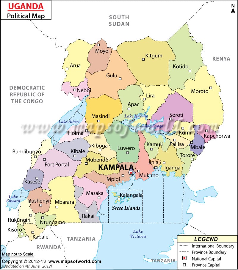
Uganda Political Map helps in finding out the provinces of the country together with the position of Uganda in the world. Some of the provinces of Uganda are Arua, Nebbi, Kitgum, Mpigi and Lira. The capital city of this eastern African country is Kampala.
Uganda Location
Uganda is located in Eastern Africa to the west of Kenya. It falls on the coordinates of 1° North latitude and 32° East longitude. It is bordered by Sudan in the north, Kenya in the east, Tanzania and Rwanda in the south and Zaire in the west. Uganda covers an area of approximately 236,040 sq km. Uganda Political Map shows the various provinces into which the country is divided.
Uganda Provinces
Some of the important provinces of Uganda are given below:-
|
They have been marked on the Uganda Political Map by a white square.
The Sese Islands lies in the south-eastern part of Uganda and has been shown by a dark black font on the Uganda Map. The national and the international boundary have been very clearly shown on the map by black uneven lines.
Capital of Uganda
Kampala, which is the capital city of Uganda, lies on the coordinates of 0° 19' North latitude and 32° 25' East longitude. It is marked on the Political Map of Uganda by a red square. It is located at a height of 1202 meters above sea level. This place can be accessed from the Entebbe international Airport. Some of the nearby locations include Mengo, Lugala and Makerere.
District | Population |
---|---|
Abim | 58,590 |
Adjumani | 201,493 |
Amolatar | 96,374 |
Amuria | 183,817 |
Amuru | 177,783 |
Apac | 405,524 |
Arua | 413,113 |
Budaka | * 221,525 |
Bududa | 124,368 |
Bugiri | 426,522 |
Bukedea | 122,527 |
Bukwo | 49,826 |
Buliisa | 64,823 |
Bundibugyo | 212,884 |
Bushenyi | 723,427 |
Busia | 228,181 |
Butaleja | 160,927 |
Dokolo | 131,047 |
Gulu | 290,624 |
Hoima | 349,204 |
Ibanda | 198,043 |
Iganga | 547,155 |
Isingiro | 318,913 |
Jinja | 413,937 |
Kaabong | 379,775 |
Kabale | 471,783 |
Kabarole | 359,180 |
Kaberamaido | 122,924 |
Kalangala | 36,661 |
Kaliro | 153,513 |
Kampala | 1,208,544 |
Kamuli | 558,566 |
Kamwenge | 295,313 |
Kanungu | 205,095 |
Kapchorwa | 143,684 |
Kasese | 532,993 |
Katakwi | 123,215 |
Kayunga | 297,081 |
Kibaale | 413,353 |
Kiboga | 231,718 |
Kiruhuura | 212,087 |
Kisoro | 219,427 |
Kitgum | 286,122 |
Koboko | 131,604 |
Kotido | 157,765 |
Kumi | 265,488 |
Kyenjojo | 380,362 |
Lira | 530,342 |
Luwero | 336,616 |
Lyantonde | 66,175 |
Manafwa | 264,383 |
Masaka | 767,759 |
Masindi | 405,042 |
Mayuge | 326,567 |
Mbale | 332,174 |
Mbarara | 360,008 |
Mityana | 269,763 |
Moroto | 170,506 |
Moyo | 199,912 |
Mpigi | 414,757 |
Mubende | 436,493 |
Mukono | 807,923 |
Nakapiripirit | 153,862 |
Nakaseke | 138,011 |
Nakasongola | 125,297 |
Namutumba | 169,156 |
Nebbi | 433,466 |
Ntungamo | 386,816 |
Nyadri | 310,338 |
Oyam | 270,720 |
Pader | 293,679 |
Pallisa | * 300,729 |
Rakai | 405,631 |
Rukungiri | 308,696 |
Sembabule | 184,178 |
Sironko | 291,906 |
Soroti | 371,986 |
Tororo | 398,601 |
Wakiso | 957,280 |
Yumbe | 253,325 |
80 districts | 24,748,977 |
Last Updated On : October 12, 2012