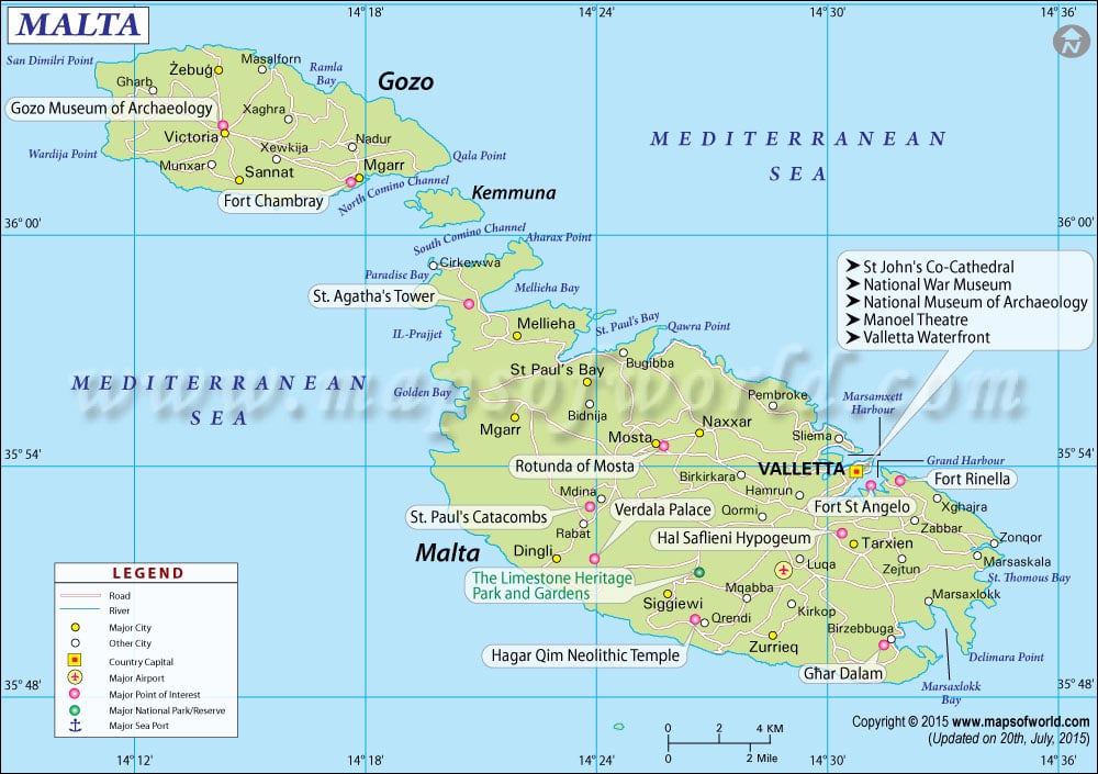
Malta Map

- Continent And Regions - Europe Map
- Other Malta Maps - Where is Malta, Malta Blank Map, Malta Road Map, Malta Cities Map, Malta Political Map, Malta Physical Map, Malta Flag
Explore this Malta map to access everything you want to know about this country. Learn about the location of Malta on the world map, official flag symbol, geography, climate, postal/zip codes, time zones, etc. Check out the significant places, history provinces/regions, & cities, most famous travel destinations and attractions, the location of the capital city, facts and trivia, Top FAQs (Frequently Asked Questions), and many more.
About Malta
Malta, known as Republika ta’ Malta, is officially an island nation in the Mediterranean Sea and is often considered part of Southern Europe. Malta consists of an archipelago between Sicily and North Africa. The island country comprises a group of seven islands in the Mediterranean Sea. Malta covers a total land area of 316 km2 (122 sq mi). The coastline of the Island nation extends up to 196.8 kilometers. The largest city of Malta is Birkirkara, and the capital city is Valletta. On September 21, 1964, Malta gained its independence and became a republic on December 13, 1974.
Malta Flag
The present flag of Malta was adopted on September 21, 1964. The flag’s design is bicolor, consisting of two vertical bands of white and red. The flag has the representation of George Cross edged in red on the upper hoist-side corner of the white band.
Malta Location
The Malta location Map shows the exact location of Malta on the world map. This map depicts the boundaries of this country, neighboring countries, and oceans. The country is located 80 km(50 mi ) south of Italy, 284 km (176 mi) east of Tunisia, and 333 km (207 mi) north of Libya. Malta’s Latitude and Longitude extents are 35.53’0” N Latitude and 14.30’0” E Longitude in Europe. One can check the Latitude and Longitude Map of Malta for more information.
Malta Capital
The capital city of Malta is Valletta. The capital city, which is also the administrative unit of Malta, is located on the main island, between Grand Harbour to the east and Marsamxett Harbour to the west. Valletta is the European Union’s smallest capital city. Check Where is Valletta to know about the location of Valletta.
Time Zones in Malta
Malta uses only a one-time zone; Central European Standard Time (CET) is one hour ahead of UTC (coordinated universal time), that is, UTC+1. Malts observe daylight saving time as Central European Summertime (CEST), where the clocks are switched forward by 2 hours in summer (UTC +2). Check Malta Time Zone Map to learn more.
Malta Geography
The physical map of Malta has revealed all the details about the country’s physical features, including mountain peaks, rivers, and lakes. Geographically, the country belongs to the Liguro-Tyrrhenian province of the Mediterranean Region within the Boreal Kingdom. Malta, Gozo, Manoel, and Comino are the significant islands of Malta that are inhabited. The smaller islands inhabited are Cominotto, Fungus Rock, Manoel Island, Filfa, and Islands of St.paul. The terrain of the Island nation is mainly hilly, with its highest point being 253 meters (830 feet) above sea level at Ta’Dmejrek.
Malta Climate
The climatic conditions of Malta are classified as a Mediterranean climate. There are very mild winters and warm to hot summers. In Malta, Rain occurs mainly in the winter, with the summer season generally dry.
Malta Major Cities
The Malta City Map reveals valuable details, including the capital city and administrative divisions. Major towns of Malta marked with black dots on the map are:
- Dingli
- Zurrieq
- Zabbar
- Birzebbuga
- Zaitun
- Zurrieq
- Sannat
- Gharb
- Rabat
Regions in Malta
The Island Nation is divided into five regions. These regions are:
- Central Region
- Gozo Region
- Northern Region
- South Eastern Region
- Southern Region
Malta Airports
Malta has only one international airport located in the center of the island in the town of Luqa. The airport is known as Malta International Airport. The other two domestic airports are Gozo Heliport Airport and Heliport Airport. Check the Malta Airport Map to learn more.
Malta Postal or ZIP Codes
Postal codes in Malta consist of seven digits. The format of Lithuanian postal codes consists of three parts. The first three digits in the Malta postal codes indicate the area, the following three indicate the street code, and the last indicates the delivery point or address.
Malta Travel
The Island Nation is a year-round destination that can be explored at all times of the year. Malta is home to many picturesque beaches and natural spots. The Island Country has sandy as well as rocky beaches. The Island nation has three UNESCO World Heritage Sites. Some of the most popular tourist destinations of Malta are:
- Luqa
- Valletta
- Zebbug
- Birkirkara
- Bugibba
- Msida
- Naxxar
- Madina
Top FAQs on Malta
FAQ #1: How big is Malta?
Ans: Malta is about 316 km2.
FAQ#2: Is Malta part of Italy?
Ans: No, Malta is not part of Italy. It became an independent state on September 21, 1964.
Faq #3 What language is spoken in Malta?
Ans: The official languages spoken in Malta are Maltese and English.
Faq#4:What is Malta famous for?
Ans: Malta is known for its beautiful landscapes that serve as locations for primary film production.