- UAE Cities - Abu Dhabi, Ajman, Fujairah, Ras-Al-Khaimah, Sharjah, Umm Al Quwain
- Neighboring Countries - Dubai, Oman, Saudi Arabia, Bahrain, Iran
- Continent And Regions - Asia Map
- Other UAE Maps - UAE Map, Where is UAE, UAE Blank Map, UAE Physical Map, UAE Flag
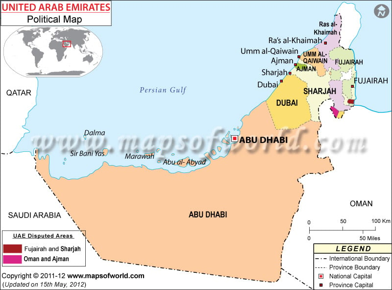
The United Arab Emirates, known as the UAE, is a Middle Eastern nation on the Arabian Peninsula. The United Arab Emirates is situated along the Persian Gulf, and is across the gulf from Qatar and Iran.
The UAE borders Oman and Saudi Arabia. The United Arab Emirates is headquartered in its capital, Abu Dhabi, while its largest city is Dubai.
The United Arab Emirates is made up of seven emirates: Abu Dhabi, Ajman, Dubai, Fujairah, Ras al-Khaimah, Sharjah, and Umm al-Quwain. Each of the emirates is headquartered in a capital by the same name.
The largest emirate by population is Dubai, with about 35 percent of the population, at over 2 million people. The second largest emirate by population is Abu Dhabi, which is home to over 31 percent of the country’s population. Abu Dhabi is the largest emirate in area, making up over 86 percent of the country, followed by Dubai and Sharjah. The two areas of Fujairah and Sharjah, and Oman and Ajman are under joint control.
| Name | Population | Area(km.²) | Area(mi.²) |
|---|---|---|---|
| Abu Dhabi | 1,292,119 | 67,350 | 26,000 |
| Ajman | 189,849 | 250 | 100 |
| Dubay | 1,200,309 | 3,900 | 1,500 |
| Fujayrah | 118,617 | 1,200 | 500 |
| Ras al Khaymah | 197,571 | 1,700 | 700 |
| Sharjah | 724,859 | 2,600 | 1,000 |
| Umm al Qaywayn | 45,756 | 800 | 300 |
| 7 emirates | 3,769,080 | 77,800 | 30,100 |

 UAE Independence Day