- Newzealand Regions - Manawatu-Wanganui, Bay of Plenty, Otago, West Coast, Nelson, Waikato, Taranaki, Canterbury, Hawkes Bay, Northland, Marlborough, Auckland, Gisborne, Tasman, Southland, Wellington
- Continent And Regions - Oceania Map
- Other Newzealand Maps - Newzealand Map, Where is Newzealand, Newzealand Blank Map, Newzealand Road Map, Newzealand Rail Map, Newzealand River Map, Newzealand Cities Map, Newzealand Physical Map, Newzealand Flag
The geographic coordinates of New Zealand are 41° South latitude and 174° East longitude. The prime Minister of New Zealand is the head of the government.
The total area covered by the country is 268, 680 square kilometers. New Zealand experiences temperate climate. Natural Gas, sand, coal, limestone and gold are some of the natural resources of the country. Maori, English and Sign Language are the official languages of New Zealand.
Political New Zealand Map :
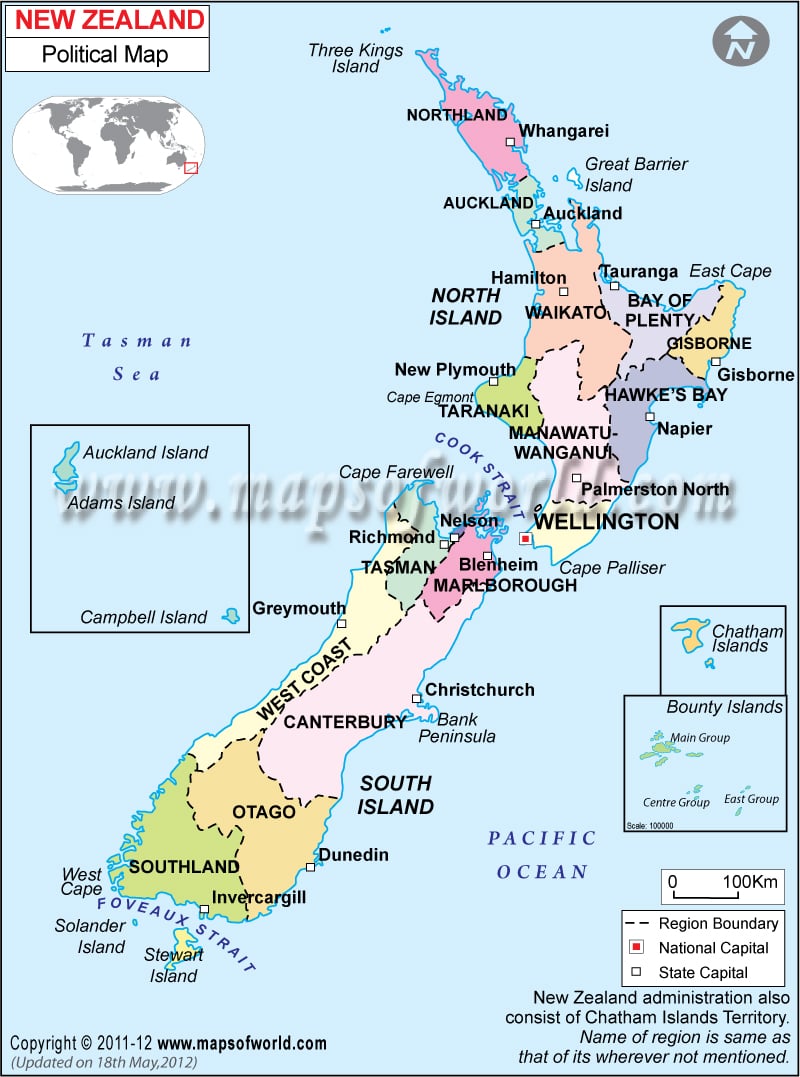
New Zealand is located to the southwestern side of Australia in the Southern Pacific Ocean. The geographic coordinates of New Zealand are 41° South latitude and 174° East longitude. The coastline of the country stretches till 15,134 kilometers. The population of New Zealand as per the census of July 2007 is 4,115,771. In the political map of New Zealand the administrative divisions of the country are indicated using different colors. The international boundaries, national capital, major cities have been highlighted in the printable political map of New Zealand.
New Zealand Regions :
There are 16 regions in New Zealand. The various regions of the country have been indicated in the printable map of New Zealand by various colors. Chatham Islands is a territory of New Zealand. The regional boundaries of the country have also been indicated by a specific pattern of black lines. The New Zealand regions are:
- Auckland
- Bay of Plenty
- Canterbury
- Gisborne
- Hawke’s Bay
- Manawatu-Wanganui
- Marlborough
- Northl
- Otago
- Southl
- Taranak
- Tasman
- Waikato
- Wellington
- West Coast
- Nelson New Zealand Capital
Wellington is the capital of New Zealand. The New Zealand capital has been highlighted in the printable New Zealand map by a red square box with black outline. The geographic coordinates of Wellington are 41°17’60” South latitude and 174°46’60” East longitude. The capital of New Zealand is located at an altitude of 68 feet. The city is served by Wellington International airport. Some more airports that are located in close proximity to the city are Paraparaumu, Masterton and Woodbourne.
Some of the cities, which are situated near Wellington, are :
- Brooklyn
- Kaiwharawhara
- Berhampore
- Kilbirnie
- Hataitai
New Zealand Region Capitals :
The capitals of the regions of the country have been pointed out in the political New Zealand map by white square boxes. The capitals of the 16 regions of the country are:
|
|
New Zealand Boundaries :
The country is bounded with water from all sides. It is positioned in the south western Pacific ocean. In the northwestern side of New Zealand there is Tasman Sea, which separates the country from Australia. In the political map of New Zealand the scale of the map is also given. To the southern tip of New Zealand there is Foveaux Strait.
Some of the other locations that are indicated in the political New Zealand map are West Cape, Stewart Island, Cape Palliser, East Cape, Cook Strait, Three Kings Island and Greater Barrier Island.
 Wall Maps