- Neighboring Countries - The Gambia, Mali, Guinea-Bissau, Guinea, Mauritania
- Continent And Regions - Africa Map
- Other Senegal Maps - Senegal Map, Where is Senegal, Senegal Blank Map, Senegal Road Map, Senegal Rail Map, Senegal River Map, Senegal Cities Map, Senegal Flag
Senegal Location
Senegal is located between Mauritania and Guinea-Bissau in Western Africa. It borders the North Atlantic Ocean. Located on the geographical coordinates of 14° North and 14° West longitude, Senegal covers an area of about 196,190 sq km. Mali lies in the western side of Senegal.
Provinces and provincial capitals
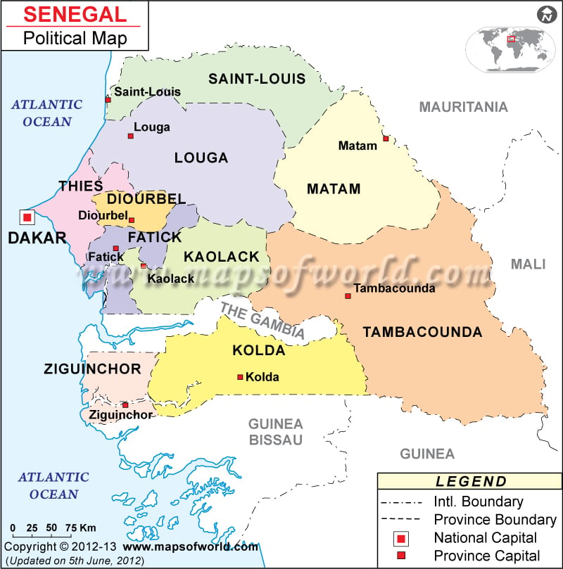
Senegal Political Map shows the provinces as well as the important locations and cities of Senegal. These provinces include Louga, Saint Louis, Dakar and Tambacounda. The provincial capitals have been marked on the Physical Map of Senegal by a white square.
These include:
- Saint Louis
- Louga
- Thies
- Diourbel
- Fatick
- Kaolack
- Tambacounda
- Kolda
- Ziguinchor
Capital City of Senegal
Dakar is located on the geographical coordinates of 14° 40′ North latitude and 17° 26′ West longitude. It is the capital of Senegal. Niaye Tioker and Le Plateau are located closely to this city. The Leopold Sedar Senghor International is the nearest airport. Dakar can be identified on the Senegal Political Map by a red square.
Senegal Cities
There are many important cities in Dakar that are marked on the Senegal Political Map by black dots. Some of them are:
|
|
| Region | Population | Area(km.²) | Area(mi.²) |
|---|---|---|---|
| Dakar | 2,459,292 | 550 | 212 |
| Diourbel | 1,183,095 | 4,359 | 1,683 |
| Fatick | 652,361 | 7,935 | 3,064 |
| Kaffrine | 467,748 | 11,853 | 4,576 |
| Kaolack | 664,959 | 4,157 | 1,605 |
| Kedougou | 111,207 | 16,896 | 6,524 |
| Kolda | 513,138 | 13,718 | 5,297 |
| Louga | 729,606 | 29,188 | 11,270 |
| Matam | 478,573 | 25,083 | 9,685 |
| Saint-Louis | 764,347 | 19,044 | 7,353 |
| Sedhiou | 399,365 | 7,293 | 2,816 |
| Tambacounda | 557,884 | 42,706 | 16,489 |
| Thies | 1,385,058 | 6,601 | 2,549 |
| Ziguinchor | 453,448 | 7,339 | 2,834 |
| 14 regions | 10,820,081 | 196,722 | 75,955 |
Note : –Population: 2005 estimates.
| Region | Population | Area(km.²) | Area(mi.²) |
|---|---|---|---|
| Dakar | 2,411,528 | 550 | 212 |
| Diourbel | 930,008 | 4,359 | 1,683 |
| Fatick | 639,075 | 7,935 | 3,064 |
| Kaolack | 1,128,128 | 16,010 | 6,181 |
| Kolda | 834,753 | 21,011 | 8,112 |
| Louga | 559,268 | 29,188 | 11,270 |
| Matam | 291,555 | 25,083 | 9,685 |
| Saint-Louis | 571,885 | 19,044 | 7,353 |
| Tambacounda | 530,332 | 59,602 | 23,012 |
| Thies | 1,348,637 | 6,601 | 2,549 |
| Ziguinchor | 557,606 | 7,339 | 2,834 |
| 11 regions | 9,802,775 | 196,722 | 75,955 |
Note : –Population: 2001-01-01 estimate, provided by Karem Abdalla.

 Senegal Distance Calculator and Driving Directions