Northern Europe Map

-
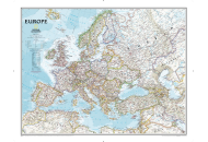
Europe Classic Map
$13.84
-
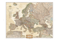
Europe Executive Map
$13.84
-
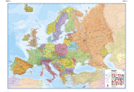
Europe Political Map
$34.61
| Description : Northern Europe Map shows the location and the international boundaries of countries that belong to the region. | Disclaimer |
×
Disclaimer : All efforts have been made to make this image accurate. However MapSherpa, Inc, its directors and employees do not own any responsibility for the correctness or authenticity of the same.


