- Neighboring Countries - Laos, Thailand, Bhutan, Bangladesh, China
- Continent And Regions - Asia Map
- Other Myanmar Maps - Myanmar Map, Where is Myanmar, Myanmar Blank Map, Myanmar Road Map, Myanmar Rail Map, Myanmar River Map, Myanmar Cities Map, Myanmar Physical Map, Myanmar Flag
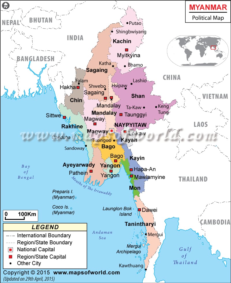
The Republic of the Union of Myanmar, formerly known as Burma, is a nation in Southeast Asia. Myanmar shares borders with China, Thailand, India, Laos, and Bangladesh, as well as the Bay of Bengal and the Andaman Sea.
Myanmar, which is also frequently called Burma, has an area of 676,578 square kilometers (261,227 square miles), and a population over 60 million people.
The capital of Myanmar is Naypyidaw, which is located in the Mandalay region of the country. Myanmar is separated into seven states and seven regions.
The states of Myanmar are Kachin, Kayah, Kayin, Chin, Mon, Rakhine, and Shan. Each of these states is primarily home to a particular ethnic minority of Myanmar. The regions of Myanmar, on the other hand, are predominantly inhabited by Bamar people (or Burman), the majority ethnic group. The regions of Myanmar are Sagaing, Tanintharyi, Bago, Magway, Mandalay, Yangon, and Ayeyarwady.
The states and regions are both further divided into districts, cities, wards, and villages. Each state and region has its own capital for local government.
States and Capitals of Myanmar |
|---|
| State | Pop-2003 | Pop-1983 | Area(km.²) | Capital |
|---|---|---|---|---|
| Kachin | 1334670 | 903982 | 87808 | Myitkyina |
| Kayah | 284630 | 168355 | 11670 | Loikaw |
| Kayin | 1543107 | 1057505 | 28726 | Pa-an |
| Chin | 487361 | 368985 | 36009 | Hakha |
| Mon | 2671396 | 1682041 | 11831 | Mawlamyaing |
| Rakhine | 2618392 | 2045891 | 36762 | Sittwe |
| Shan | 4994364 | 3718706 | 158222 | Taunggyi |
Regions and Capitals of Myanmar |
|---|
| Region | Pop-2003 | Pop-1983 | Area(km.²) | Capital |
|---|---|---|---|---|
| Sagaing | 5535035 | 99150 | 38282 | Sagaing |
| Tanintharyi | 1455098 | 43328 | 16729 | Dawei |
| Bago | 5186619 | 49787 | 19223 | Bago |
| Magway | 4770905 | 44799 | 17297 | Magway |
| Mandalay | 7286448 | 34253 | 13225 | Mandalay |
| Yangon | 5930728 | 521 | 201 | Yangon |
| Ayeyarwady | 7183541 | 35167 | 13578 | Pathein |
 Wall Maps
 Facts about Myanmar