- Neighboring Countries - Indonesia, Australia
- Continent And Regions - Asia Map
- Other Timor-Leste Maps - Timor-Leste Map, Where is Timor-Leste, Timor-Leste Blank Map, Timor-Leste Road Map, Timor-Leste Cities Map, Timor-Leste Flag
Timor Leste is located at South East Asia. The total area covered by the country is 15,007 kilometers. Timor Leste has mountainous terrain. Petroleum, gold, manganese, marble and natural gas are the natural resources of the country.
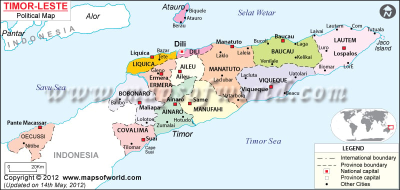
The population of the country as per the estimate of July 2007 is 1,084,971. The Timor Leste political map features the national capital and major cities, which have been clearly indicated by specific symbols. The symbols have been explained in the legend box below the map.
Timor Leste Political Features
Timor Leste is a southeastern Asian country. Timor Leste is located at the eastern end of the archipelago of Indonesia. The geographic coordinates of Timor Leste are 8° 50′ South latitude and 125° 55′ East longitude. The coastline of the country extends to 706 kilometers. Timor Leste experiences tropical climate.
Timor Leste Administrative Divisions
Timor Leste has been divided into 13 administrative districts. The eastern portion of Timor Island, Pulau Jaco and Pulao Atauro islands, Oecussi region, which is located to the northwestern part of Timor Island are all included in the nation of Timor Leste. The Timor Leste districts are Ainaro, Aileu, Bobonaro (Maliana), Baucau, Dili, Cova-Lima (Suai), Lautem (Los Palos), Ermera, Manatuto, Liquica, Oecussi (Ambeno), Manufahi (Same) and Viqueque. The internal boundaries of the country districts are marked in the political Timor Leste map. Some of the capitals of the administrative districts, which have been highlighted in the political map of Timor Leste by white squares, are:
- Pante Macassar
- Suai
- Ainaro
- Alleu
- Liquica
- Manatuto
- Viqueque
- Lospalos
- Baucau
Timor Leste Capital
The capital of Timor Leste is Dili, which is located to north coast of the island of Timor. Dili also happens to be the largest city of the country. The geographic coordinates of Dili are 8° 33′ 31″South latitude and 125° 34′ 25″East longitude. The national capital is 39 feet above sea level. Dili is served by Comoro international airport, which is also popular by the name of Presidente Nicolau Lobato International Airport. Some of the nearby cities of Dili are Parol, Bairo Alto, Palapasot, Audian, Borohun.
Timor Leste Cities
The major cities of Timor Leste have been marked in the political printable map of Timor Leste by black dots. Some of the indicated cities of the island nation are Nitibe, Zumalai, Lolotoe, Hotudo, Laclubar, Gleno, Kelokai, Lacluta, Laga, Bucoji, Laivai, Lautem, Lore, Com, Tutuala.
| District | Population | Area(km.²) | Area(mi.²) | Capital | Capital (Ind.) |
|---|---|---|---|---|---|
| Aileu | 39,648 | 729 | 282 | Aileu | Aileu |
| Ainaro | 55,381 | 797 | 308 | Ainaro | Ainaro |
| Ambeno | 60,687 | 815 | 315 | Pante Macassar (Oecusse) | Pante Makasar |
| Baucau | 106,225 | 1,494 | 577 | Baucau | Baukau |
| Bobonaro | 88,342 | 1,368 | 528 | Maliana | Maliana |
| Cova Lima | 55,714 | 1,226 | 473 | Suai | Suai |
| Dili | 181,997 | 372 | 143 | Dili | Dili |
| Ermera | 107,557 | 746 | 288 | Ermera | Ermera |
| Lautem | 59,241 | 1,702 | 657 | Los Palos | Los Palos |
| Liquica | 57,978 | 543 | 210 | Liquica | Likisia |
| Manatuto | 39,015 | 1,706 | 658 | Manatuto | Manatuto |
| Manufahi | 47,568 | 1,325 | 512 | Same | Same |
| Viqueque | 70,002 | 1,781 | 687 | Viqueque | Vikeke |
| 13 districts | 969,355 | 14,604 | 5,638 |

 East Timor Independence Day