logo


Faroe Islands Latitude and Longitude Map
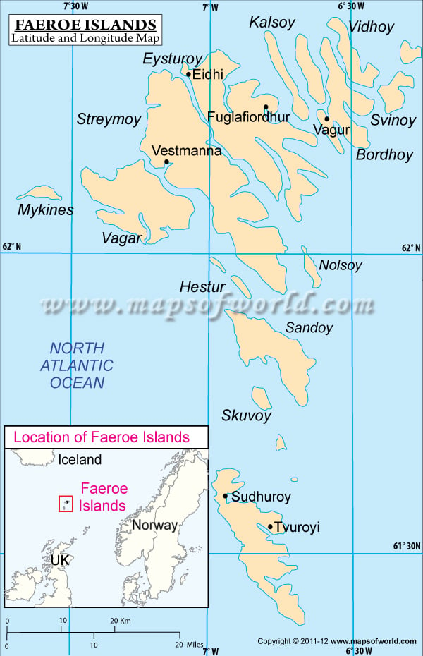
Faroes's latitude and longitude is 62° 00' N and 7° 00' W . Below is the map of Faroes showing major towns, roads, airports with latitudes and longitudes plotted on it.
Faroe Islands Latitude and Longitude Map
Description : Find Faroe Islands latitude and longitude map showing comprehensive details including cities, roads, towns, airports and much more. Disclaimer
×

Disclaimer  :  All efforts have been made to make this image accurate. However MapSherpa, Inc, its directors and employees do not own any responsibility for the correctness or authenticity of the same.


Search For Latitude & Longitude Map

By Country

Or

Latitude

Longitude

Or

Area

* Put South & West values with minus ( - ) sign.


The Faroe Islands or the Faroes is located on the North Atlantic at the geographic coordinates of 62°00'N latitude and 7°00'W longitude .

An autonomous region of Denmark since 1948, the Faroe Islands span an area of 1399 sq km across it's latitude and longitude. Faroes mean Sheep Islands in the native language. The capital of the Faroe Islands is Tórshavn, having geographic coordinates of 62°01'N latitude and 06°46'W longitude respectively.

The geographic latitude and longitude of the Faroe Islands encompasses the 18 islands spread off the coast of Europe. Lying between the Norwegian Sea and the North Atlantic, the latitude and longitude of the Faroes is responsible for the temperate climate of the region. There are cool summers and relatively mild winters. The skies are usually cloudy and the region is known to be windy and foggy. The terrain is rugged and has some low peaks, the highest of which is Slaettaratindur, with a height of 882 m.


Latitude and Longitude of Faroe Islands

LocationLattitudeLongitude
Eysturoy62°13'N06°54'W
Kalaksvik62°14'N06°35'W
Mykines62°07'N07°35'W
Norooyar62°17'N06°35'W
Sandoy61°52'N06°46'W
Vagar62°5'N07°15'W

Last Updated on: November 14th, 2017