South Asia Map
The term South Asia represents the southern region of Asia. South Asia comprises the following countries - Afghanistan, Bangladesh, Bhutan, India, Nepal, Maldives, Pakistan and Sri Lanka.
-
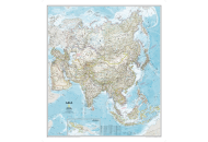
Asia Classic Map
$16.95
-
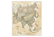
Asia Executive Map
$16.95
-
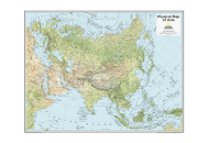
Asia Physical Map
$18.99
| Description : The South Asia Map shows the various countries that are a part of the region. | Disclaimer |
×
Disclaimer : All efforts have been made to make this image accurate. However MapSherpa, Inc, its directors and employees do not own any responsibility for the correctness or authenticity of the same.