- Neighboring Countries - Cuba, United States, Haiti
- Continent And Regions - North America Map, Americas Map
- Other Bahamas Maps - Bahamas Map, Where is Bahamas, Bahamas Blank Map, Bahamas Cities Map, Bahamas Flag
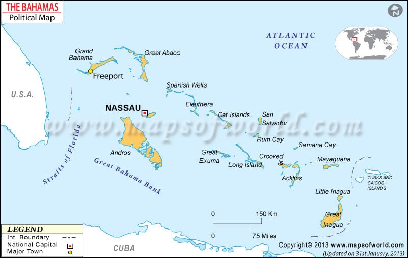
The Commonwealth of the Bahamas is a country located in the Atlantic Ocean. As the Bahamas Political Map shows, the nation lies to the north of Cuba and Hispaniola( Dominic Island and Haiti, northwest of the Turks and Caicos Islands, and southeast of the United States.
The country covers an area of 5,358 square miles. It comprises 29 islands, 661 cays, and 2,387 islets.
The Bahamas political map shows the various islands that make up the nation. The national capital, Nassau is clearly represented on the map. The capital city is located on New Providence Island. The major islands are Acklins, Berry Islands, Cat Island, Harbour Island, and Grand Cay.
Acklins
The island group named Acklins is one of the many Bahamian districts. It is located in the Bight of Acklins, which may be described as a thin lagoon. The American loyalists were among the earliest Europeans to have settled in the islands.
Berry Islands
The total area encompassed by the Bahamian island chain named Berry Islands is 30 square miles. It is located in the northwestern region of the Out Islands. There are almost 30 islands in the region that also inclusive of more than 100 cays.
Cat Island
Cat Island is a part of the central Bahaman region. It is home to Mount Alvernia, which has a height of 206 feet. It also houses a monastery named The Hermitage. John Hawes, who was also known as Brother Jerome, is credited with setting up these buildings.
East Grand Bahama
East Grand Bahama is among the 32 districts in the Caribbean country. Its regional government is headquartered at High Rock, which can be called a comparatively smaller town.
Grand Cay
Grand Cay is a part of the Abaco Islands group located on a southern route from Walkers. It is a top tourist destination with Rosie’s Place being the numero uno attraction. Besides, tourists can also get their hands on delicacies like cracked conch, lobster gill, turtle steak, and grilled grouper.
Besides, critical areas such as New Providence, Great Inagua, and Grand Bahama are also exhibited on the political map of the Bahamas.
The Bahamas is a parliamentary democracy and Queen Elizabeth II is the head of the state. She is represented by the Governor-General. Cornelius Alvin Smith is the current Governor-General of the nation. Philip Edward Davis is the current Prime Minister of the Bahamas.
| District | Pop-1953 | Pop-1990 | Area(km.²) | Area(mi.²) | Chief town |
|---|---|---|---|---|---|
| Abaco | 3,407 | 10,061 | 1,681 | 649 | Marsh Harbour |
| Acklins Island | 1,273 | 428 | 389 | 150 | Masons Bay |
| Andros | 7,136 | 8,155 | 5,957 | 2,300 | Nicholls’ Town |
| Berry Islands | 327 | 634 | 31 | 12 | Bullocks Harbor |
| Biminis | 1,325 | 1,638 | 23 | 9 | Alice Town |
| Cat Island | 3,201 | 1,678 | 388 | 150 | Arthur’s Town |
| Cay Lobos | 5 | 25 | 18 | 7 | Cay Lobos |
| Crooked Island | 836 | 423 | 238 | 92 | Colonel Hill |
| Eleuthera | 6,070 | 9,300 | 518 | 200 | Governor’s Harbour |
| Exuma | 2,919 | 3,539 | 290 | 112 | Georgetown |
| Grand Bahama | 4,095 | 41,035 | 1,373 | 530 | Freeport |
| Harbour Island | 840 | (a) | 4 | 2 | Dunmore Town |
| Inagua | 999 | 985 | 1,671 | 645 | Matthew Town |
| Long Cay | 80 | (b) | 23 | 9 | Albert Town |
| Long Island | 3,755 | 3,107 | 448 | 173 | Clarence Town |
| Mayaguana | 615 | 308 | 110 | 42 | Abraham’s Bay |
| New Providence | 46,125 | 171,542 | 207 | 80 | Nassau |
| Ragged Island | 320 | 89 | 23 | 9 | Duncan Town |
| Rum Cay | 133 | (c) | 78 | 30 | Port Nelson |
| San Salvador | 694 | 539 | 163 | 63 | Cockburn Town |
| Spanish Wells | 686 | (a) | 1 | 0 | Spanish Wells |
 Wall Maps
 Bahamas Facts