What are the Key Facts of Saint Kitts and Nevis?
|
Official Name |
Saint Kitts and Nevis |
|
Continent |
North America (Caribbean) |
|
Capital |
Basseterre |
|
Largest City |
Basseterre |
|
Coordinates |
17.333333, -62.750000 |
|
Area |
101 sq. mi ( 261 sq. km) |
|
Land Boundaries |
0 mi ( 0 km) |
|
Coastline |
84 mi ( 135 km) |
|
Currency |
East Caribbean dollar (XCD) |
|
Neighboring Countries |
Maritime neighbors: Montserrat, Antigua and Barbuda, Anguilla |
|
Population |
54,821 (2016 est. ) |
|
Official Languages |
English |
|
Major Religion |
Christianity |
|
National Day |
19 September (Independence Day) |
|
National Anthem |
“Oh Land of Beauty!” |
|
Form of Government |
Federal parliamentary constitutional monarchy |
|
Monarch |
Elizabeth II |
|
Prime Minister |
Timothy Harris |
|
GDP per capita (PPP) |
$ 31,831.3 (World Bank, 2018) |
|
GDP per capita (nominal) |
$ 19,829.4 (World Bank, 2018) |
|
HDI |
0.778 (2017), Rank: 72 |
|
Literacy Rate (%) |
NA |
|
Space Agency |
NA |
|
Military Expenditure Ranking |
NA (SIPRI, 2017) |
|
No. of Olympic Medals |
0 (as of 2018) |
|
Driving Side |
left |
|
Calling Code |
+1 869 |
|
Time Zone |
UTC-4 |
|
Internet TLD |
.kn |
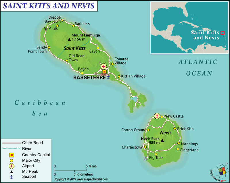
Where is Saint Kitts and Nevis?
Saint Kitts and Nevis is a two-island nation that is located in the eastern Caribbean Sea. Both these islands of Saint Kitts and Nevis are the summits of a volcanic mountain range submerged under water. This Caribbean nation in Central America is situated around 1/3rd of the distance from Puerto Rico to Trinidad and Tobago.
What is the Geography of Saint Kitts and Nevis?
Saint Kitts and Nevis has a total area of 261 sq. km (101 sq. mi), out of which Saint Kitts has a 168 sq. km (65 sq. mi) area and Nevis has a 93 sq. km (36 sq. mi) area. There is no water area present in this country. The land area is spread across 261 sq. km (101 sq. mi). The country doesn’t share the land area with any other country. Saint Kitts and Nevis has a 135 km (84 mi) long coastline.
The highest elevation point of this nation is Mount Liamuiga at 1,156 m (3,793 ft) and the lowest one is sea level at Caribbean Sea. Other important mountains of the country are Nevis Peak and Olivees Mountain. There are dozens of rivers crisscrossing this island nation, such as Parsons Ghut, Lodge Ghut, Cayon River, Fountain River, Camp River, New River Ghut, etc.
Generally speaking, Nevis is a cone-shaped island having a narrow coastal plain. As it moves towards the center, the landform rises into the upper elevations gradually. White and black sand beaches are scattered across the Nevis Island, while St. Kitts is an elongated oval. To the southeast of the St. Kitts island, a long and narrow peninsula is present. The coastal plain is also narrow, which rises into the upper elevations steeply.
Moreover, the islands of Saint Kitts and Nevis have a tropical climatic condition, which is tempered by constant sea breeze. From one season to the other, there is hardly any variation in temperature (which remains hot and humid round the year). The northeast trade winds blow constantly during the relatively cool and dry season (from January to mid-April).
Also, the coldest months of these islands are in January and February (the daily average temperature revolves around 25 ˚C or 77 °F). The hottest temperature prevails from June-to-October (the average revolves around 28 °C or 82 °F).
In addition, incessant rainfall is accompanied by hot and humid temperature during the rainy season (May-to-November). The average annual rainfall in this island nation revolves around 2,400 mm (90 in).
What is the Economy of Saint Kitts and Nevis?
Saint Kitts and Nevis had a nominal GDP of US$1,040 million in 2018. The country had an economic growth of 3% in 2018, more than double of the same in 2017 (which was 1.2%). In terms of GDP, this two-island nation has a rank of 184 among 196 countries.
Further, the economy of Saint Kitts and Nevis depends mainly on tourism (since the 1970s when the impetus was shifted from sugarcane production to tourism and small-scale industries). Other main components of the country’s economic growth are light manufacturing industries and agriculture. Public debt has dropped from 154% to 83% of the GDP during 2011-13.
Significantly, poverty is declining steadily since the year 2000. In 2008, the rate of poverty was 21.8%. During 2000-2008, the extreme poverty in Saint Kitts Island dropped from 11% to 1.4%. During the same time on Nevis Island, extreme poverty dropped from 17% to nil. 2007 figures show that the total unemployment rate was 5.1% (while it was 6.3% in Saint Kitts, 1.5% in Nevis).
What is the Transportation System of Saint Kitts and Nevis?
The transportation system in this two-island federation includes roadways, taxis, public buses, ferries, airways, and railway. Most of the major roadways can be found in the capital Basseterre (on the Saint Kitts island) and in Charlestown (on the Nevis island). Saint Kitts and Nevis has 383 km (238 mi) of roadways, out of which 163 km (101 mi) is paved and 220 km (137 mi) is unpaved.
The public buses run on 5 routes on St. Kitts Island. They start from Basseterre and help passengers reach 5 destination points (Sandy Point and Capesterre in the west; St. Peter’s in the north; Molyneux and Saddler’s in the east of Saint Kitts) or anywhere in between.
On Nevis Island, public buses ply on the main ring-road (both ways). The destinations that you can visit at Nevis Island by traveling on public buses are Charlestown, D. R. Walwyn Plaza (southwest), Memorial Square (north), etc.
Besides, ferries can be used for transportation from St. Kitts to Nevis and back. There are 220 merchant marine ships in the country and the main seaports are Basseterre and Charlestown. There are two airports in this island nation. While Robert L. Bradshaw International Airport is located on Saint Kitts island (serving Basseterre city), Vance W. Amory International Airport is located on the Nevis Island.
A 50 km long narrow-gauge railway facility (St. Kitts Scenic Railway Train) is available for the tourists. This consists of open-air, double-decker coaches that offer circle tour of the Saint Kitts Island, running from Sandy Point to Basseterre.
What International Organizations is Saint Kitts and Nevis part of?
WTO, IMF, ACP, UN, AOSIS, Petrocaribe, C, Caricom, IOC, CDB, ILO, CELAC, FAO, G-77, UNESCO, IBRD, ICAO, WHO, ICCt, ICRM, WIPO, UNCTAD, IDA, IFAD, UNIDO, IFC, IFRCS, IMO, Interpol, ITU, MIGA, OAS, OECS, OPANAL, OPCW, UPU


