GIS Mapping
GIS mapping allow us to visualize,analyze and interpret the data to understand the a relationship and trend. more…

Aerial photography
Aerial photography is the art of taking photograph of any feature, landscapes or phenomenon on the earth surface for the purpose of building maps with the help of a camera which may be mounted on any aerial platform or held in hand. more…
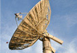
Remote Sensing
If an object, feature or phenomenon is located so remotely that it is impossible to come in contact with that object, feature or phenomenon physically, then the method of acquiring information about that particular object by using science is called remote sensing
Enterprise GIS Solutions
An enterprise GIS distribute GIS function and and data across the organization while integrating the function and offer by other technologies
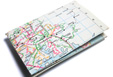
Hard Copy Maps
We sell hard copy maps of different sizes, types and mapping brands like : national geographic, Michelin, Lonely planet etc.. more…