What are the Key Facts of Colombia?
|
Official Name |
Republic of Colombia |
|
Continent |
South America |
|
Capital |
Bogotá |
|
Largest City |
Bogotá |
|
Coordinates |
4.000000, -72.000000 |
|
Area |
440,831 sq. mi ( 1,141,748 sq. km) |
|
Land Boundaries |
2,576 sq. mi ( 6,672 sq. km) |
|
Coastline |
1,993 mi ( 3,208 km) |
|
Currency |
Peso (COP) |
|
Neighboring Countries |
Venezuela, Brazil, Peru, Ecuador, Panama |
|
Population |
48,258,494 (2019 est. ) |
|
Official Languages |
Spanish |
|
Major Religion |
Christianity |
|
National Day |
20 July (Independence Day) |
|
National Anthem |
“Himno Nacional de la Republica de Colombia” |
|
Form of Government |
Unitary presidential constitutional republic |
|
President |
Iván Duque |
|
Vice President |
Marta Lucía Ramírez |
|
GDP per capita (PPP) |
$ 14,999.4 (World Bank, 2018) |
|
GDP per capita (nominal) |
$ 6,651.3 (World Bank, 2018) |
|
HDI |
0.747 (2017), Rank: 90 |
|
Literacy Rate (%) |
94.65 (UNESCO, 2016) |
|
Space Agency |
NA |
|
Military Expenditure Ranking |
24 (SIPRI, 2017) |
|
No. of Olympic Medals |
28 (as of 2018) |
|
Driving Side |
right |
|
Calling Code |
+57 |
|
Time Zone |
UTC−5 (COT) |
|
Internet TLD |
.co |
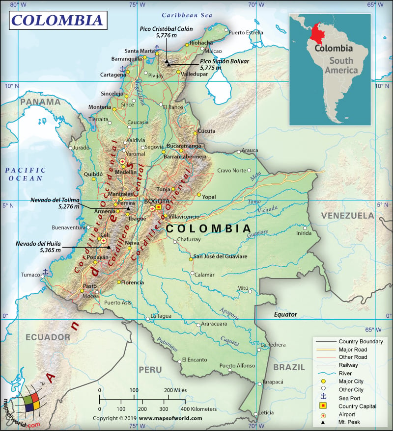
Where is Colombia?
Colombia is a transcontinental country that is mainly located inside South America but some territories are situated in North America. The country is bordered by Panama (339 km or 211 mi) to the northwest, Venezuela (2,341 km or 1,455 mi) & Brazil (1,790 km or 1,112 mi) to the east, and Peru (1,494 km or 928 mi) and Ecuador (708 km or 440 mi) to the south. Colombia also shares maritime limits with 6 countries including Costa Rica, Honduras, Nicaragua, the Dominican Republic, Jamaica, and Haiti.
What is the Geography of Colombia?
Colombia is spread over a total area of 1,141,748 sq. km (440,831 sq. mi) 1,138,910 sq. km (439,736 sq. mi), out of which 1,038,700 sq km (401,044 sq. mi) is land area and 100,210 sq km (38,691 sq. mi) is water area. The total boundary of the country is 6,672 km (4,146 mi). It has a 3,208 km (1,993 mi) coastline, out of which 1,760 km (1,094 mi) is Caribbean Sea coastline and 1,448 km (900 mi) is North Pacific Ocean coastline.
There are 6 main natural regions in Colombia and they are: the region of Andes mountain range shared with both Venezuela and Ecuador, the Pacific coastal region that is shared with both Ecuador and Panama, the Caribbean coastal region shared with both Panama and Venezuela, the Llanos region that is shared with Venezuela, the region of Amazon Rainforest that is shared with four countries (Ecuador, Peru, Brazil, and Venezuela), and the insular region consisting the islands located in both Pacific and Atlantic Ocean.
A region within the Andes in Colombia is known as the Ring of Fire, which is known for its volcanic eruptions as well as earthquakes. There are 3 branches beyond the Colombian Massif, and they are the Cordillera Occidental, the Cordillera Central, and the Cordillera Oriental.
The Cordillera Occidental runs adjacent to the Pacific coast that includes the Cali city. The peaks in this branch of mountains exceed 4,700 m (15,420 ft). The Cordillera Central runs between two river valleys: Cauca and Magdalena. The cities included in this second branch are Armenia, Pereira, Manizales, and Medellín. The 3rd branch, Cordillera Oriental, extends from northeast to the Guajira Peninsula. The cities included in this section are Cúcuta, Bucaramanga, and Bogotá. The peaks in both Cordillera Central and Cordillera Oriental reach 5,000 m (16,404 ft).
The mean elevation of Colombia is 593 m (1945 mi). While the highest elevation point is Pico Cristobal Colon at 5,730 m (18,799 ft), the lowest elevation point is sea level at the Pacific Ocean. The major rivers of the country are Magdalena, Guaviare, Cauca, Caquetá, Putumayo, Meta, Atrato, and Guaviare.
The overall climate in Colombia is tropical. However, temperature, rainfall, humidity, and winds vary as per altitude. There are 5 major climatic zones: tropical rainforest, mountain, steppes, savannas, and desert climates.
The warm altitudinal zone is found in areas having an elevation below 1,000 m (3,281 ft), comprising 80% of Colombia. The average temperature remains more than 24 °C (75.2 °F). From 1,001-2,000 m (3,284-6,562 ft) average temperature revolves around 17-24 °C (62.6-75.2 °F). The cold climate is found at 2,001-3,000 m (6,565-9,843 ft) altitude, where temperature ranges from 12-to-17 °C (53.6-to-62.6 °F). The forested zone has alpine climatic conditions. The glacial climate is found at an altitude above 4,000 m (13,123 ft).
What is the Economy of Colombia?
The Colombian economy has a nominal GDP of US$ 330.228 billion and a GDP growth rate of 2.7% in 2018. The main export item of the country is petroleum, accounting for 45% of the total exports of Colombia. The manufacturing sector is growing at an average of 10% per annum. It accounts for 12% of the total exports. The country also has the fastest growing IT sector in the world, enabled by the longest fiber-optic network in Latin America. It has one of the world’s largest shipbuilding industries, especially outside Asia.
During 2000-2010, some of the industries that expanded dramatically are electronics, shipbuilding, tourism, automobile, mining, and construction. Colombia is the second-largest producer of electronics and appliances in Latin America. The tourism sector is also expanding at over 12% per year. The total number of tourists in the country is expected to reach more than 15 million by 2023.
The economy is expected to witness growth by 3.5% in 2019. The poverty level has come down sharply from 65% in 1990 to 49.7% in 2002 and further to 27% in 2018. Extreme poverty has also come down from 17.8% in 2002 to 7.2% in 2018.
What is the Transportation System of Colombia?
The best way for transport in Colombia is roadways. 206,500 km (128,313 mi) of roads are there in the country. 69% of the cargo is transported by road, followed by railways (27%), internal waterways (3%), and airways (1%). Colombian Ministry of Transport manages the highways through the National Roads Institute. Pan American Highway crosses through the country.
2,141 km (1330 mi) of railways are there in Colombia, out of which 1,991 km (1237 mi) are narrow gauge and 150 km (93 mi) is standard gauge. There is 24,725 km (15,363 mi) of waterways in Colombia, out of which 18,300 km (11,371 mi) is navigable. Colombia has 102 merchant marine ships, out of which 18 are general cargo, 8 are oil tankers, and 76 others. Cartagena, Turbo, and Santa Marta are three major seaports in the country. 836 airports are there in Colombia, out of which 121 are paved and 715 unpaved. 3 heliports are also there. El Dorado International Airport is the busiest airport in the country.
What International Organizations is Colombia part of?
WTO, BCIE, BIS, IMF, CAN, Union Latina, CD, CDB, UN, CELAC, FAO, UNESCO, G-3, G-24, G-77, UNCTAD, IADB, IAEA, UNASUR, IBRD, ICAO, ICCt, WHO, UNHCR, UNIDO, ICRM, Pacific Alliance, IDA, IFAD, UNWTO, IFC, Interpol, IFRCS, IHO, ILO, IMO, IMSO, NAM, IOC, IOM, IPU, ISO, ITSO, ITU, LAES, LAIA, MIGA, OAS, OPANAL, OPCW, PCA, UPU, WCO, WIPO, WMO, WFTU (NGOs), ITUC (NGOs), ICC (national committees), Mercosur (associate),EITI (candidate country), Caricom (observer)
Related Links:

