What are the Key Facts of Peru?
|
Official Name |
Republic of Peru |
|
Continent |
South America |
|
Capital |
Lima |
|
Largest City |
Lima |
|
Coordinates |
-10.000000, -76.000000 |
|
Area |
496,225 sq. mi ( 1,285,216 sq. km) |
|
Land Boundaries |
4,388 mi ( 7,062 km) |
|
Coastline |
1,500 mi ( 2,414 km) |
|
Currency |
Sol (PEN) |
|
Neighboring Countries |
Ecuador, Colombia, Brazil, Bolivia, Chile |
|
Population |
31,237,385 (2017 census ) |
|
Official Languages |
Spanish |
|
Major Religion |
Christianity |
|
National Day |
28 July (Independence Day) |
|
National Anthem |
“Himno Nacional del Peru” |
|
Form of Government |
Unitary semi-presidential republic |
|
President |
Martín Vizcarra |
|
Prime Minister |
Vicente Zeballos |
|
GDP per capita (PPP) |
$ 14,393.5 (World Bank, 2018) |
|
GDP per capita (nominal) |
$ 6,947.3 (World Bank, 2018) |
|
HDI |
0.75 (2017), Rank: 89 |
|
Literacy Rate (%) |
94.15 (UNESCO, 2017) |
|
Space Agency |
Space Agency of Peru (CONIDA) |
|
Military Expenditure Ranking |
52 (SIPRI, 2017) |
|
No. of Olympic Medals |
4 (as of 2018) |
|
Driving Side |
right |
|
Calling Code |
+51 |
|
Time Zone |
UTC−5 (PET) |
|
Internet TLD |
.pe |
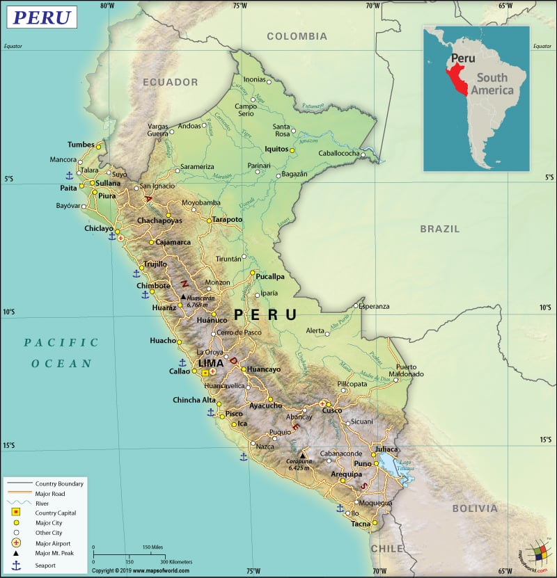
Where is Peru?
Peru is located in western South America, just south of the equator. It shares its borders with 5 countries: Ecuador (1529 km or 950 mi) and Colombia (1,494 km or 928 mi) in the north, Brazil (2,659 km or 1,652 mi) in the east, Bolivia (1,212 km or 753 mi) in the southeast, and Chile (168 km or 104 mi) in the south. In the west, Peru is bordered by the Pacific Ocean.
What is the Geography of Peru?
Peru has a total area of 1,285,216 sq. km (496,225 sq. mi), out of which 1,279,996 sq. km (494,209 sq. mi) is land area and 5,220 sq. km (2,015 sq. mi) is water area. The total land boundary of the country is 7,062 km (4,388 mi) and the coastline is 2,414 km (1500 mi) long.
Peru, the 3rd largest country of South America after Brazil and Argentina, has diversified landforms including mountains, coast, forests, and rivers. The Andes Mountains (which exceeds 6,096 m or 20,000 ft within Peruvian borders) cover a significantly large part of the country. It runs down to the sea-level beaches along the coast.
Around 12% of the landmass in Peru consists of the coast, which is located to the western direction of the Andes Mountains. This region consists of river valleys, deserts, and beaches. 50% of the landscape in Peru is covered by the Amazonian jungle, which consists of over fifty thousand species of plants, around two thousand bird types, and four hundred mammal types.
The mean elevation of Peru is 1,555 m (5102 ft). While the highest elevation point is Nevado Huascaran at 6,746 m (22,133 ft), the lowest elevation point is the sea level at the Pacific Ocean. Other major mountains of the country are Nevado Yerupajá, Nevado Coropuna, Huandoy, Huantsan, Ausangate, etc. The major rivers of Peru are Ucayali, Amazon River, Purus, Jurua River, and Maranon.
Peru has 3 climatic zones: a desert coastal strip, the Andean zone, and the large eastern area housing Amazonian forest. The desert coastal strip (also known as la Costa) has a mild climate. While the summer remains pleasantly warm, the winter remains cloudy and foggy. Coldness in the Andean zone (also called la Sierra) is dependent upon the altitude. Hot and humid climate prevails across the year in the Amazonian forest in Peru’s large eastern area.
A warm-temperate climate remains in the coastal regions. While the temperature remains comfortable, humidity remains high. The temperature reaches 30°C (86°F) during summer. A short rainy period remains during November-December.
There are two seasons in the Andean zone: summer during April-October and winter during November-March. While temperature can be around 24°C (75.2°F) during the daytime, it can be -3°C (26.6°F) at night. The Amazonian jungle also has two seasons. While April-October remains fairly dry, frequent rainfall takes place during November-March. Humidity level remains high throughout the year. Cold snaps called “friajes” or “surazos” can drive down the temperature to 8-12°C (46.4-53.6°F).
What is the Economy of Peru?
The Peruvian economy is classified as an upper-middle-income economy that has a nominal GDP of US$222.238 billion and an annual GDP growth rate of 3.977% in 2018 (World Bank). The services sector accounts for 43% of the Peruvian GDP, followed by manufacturing (32.3%). While extractive industries account for 15% of the GDP, taxes account for 9.7%.
Peru’s main pillar of strength is the high level of foreign trade. The main exports of Peru are copper, chemicals, textiles, zinc, gold, pharmaceuticals, services, manufactures, fish meal, and machinery. The external debt payments, as well as imports, are financed by the hard currency the country earns from its exports. Tourism is also a major foreign exchange earner, with Machu Picchu and UNESCO World Heritage Site Arequipa city center being some of the popular tourist attractions.
The country has a commendable HDI and it has been able to decrease its poverty level dramatically in the last 15 years. In 2004, the rate of poverty was 60%. It has now come down to 25.8% in 2012 and further to 20.5% in 2018.
What is the Transportation System of Peru?
There is 2,374 km (1,475 mi) of railway transport available in Peru. While 1,608 km (999 mi) is standard gauge, 380 km (236 mi) is narrow gauge. Ferrocarril Central Andino (FCCA) and Ferrocarriles del Sur del Perú (FCS) are the two main railways. Tren electric or Lima Metro services (34.6 km or 21.5 mi) are also there in Peru, that connect the urban districts that lie between eastern and northeastern parts of Lima.
The country has 85,900 km (53,376 mi) of total roads in Peru, out of which 45,000 km (27,961 mi) is paved and 40,900 km (25,414 mi) is unpaved. The Pan American Highway connects north-to-south Peru. Other important highways are Longitudinal de la Sierra, Carretera Central, etc. Long-distance buses help connect Lima to other important cities of Peru. There are 234 airports in the country and the most important one is Jorge Chavez International Airport, which is located in Lima. While 190 airports are unpaved, just 44 are paved.
Waterways also help Peruvian transport. While the Amazon system has 8,600 km (5344 mi) of navigable tributaries, Lake Titicaca has 208 km of waterways. Passenger and tourist boats ply on Amazon River and Lake Titicaca. Some of the major ports and harbors in Peru are Chimbote, Callao, Puno, Iquitos, and many more. 7 merchant marine ships are also present.
What International Organizations is Peru part of?
WTO, APEC, UN, BIS, UNESCO, CAN, NAM, UNCTAD, CD, UNIDO, CELAC, UNHCR, FAO, Union Latina, G-24, G-77, UNASUR, IADB, IAEA, UNWTO, IBRD, Pacific Alliance, ICAO, ICCt, LAIA, UNISFA, ICRM, IDA, MINUSTAH, ILO, IFAD, IFC, IFRCS, IHO, IMF, WHO, IMO, IMSO, Interpol, IOC, WIPO, IOM, IPU, ISO, ITSO, ITU, LAES, MIGA, MONUSCO, OAS, OPANAL, OPCW, PCA, UNAMID, UNMISS, UNOCI, UPU, WCO, WMO, ITUC (NGOs), ICC (NGOs), WFTU (NGOs), Mercosur (associate), EITI (compliant country), SICA (observer)

