What are the Key Facts of Bolivia?
|
Official Name |
Plurinational State of Bolivia |
|
Continent |
South America |
|
Capital |
Sucre, La Paz |
|
Largest City |
Santa Cruz de la Sierra |
|
Coordinates |
-17.000000, -65.000000 |
|
Area |
424,164 sq mi ( 1,098,581 sq km) |
|
Land Boundaries |
4,506 mi ( 7,252 km) |
|
Coastline |
0 mi ( 0 km) |
|
Currency |
Boliviano (BOB) |
|
Neighboring Countries |
Chile, Peru, Brazil, Paraguay, Argentina |
|
Population |
11,428,245 (2019 est. ) |
|
Official Languages |
Spanish |
|
Major Religion |
Christianity |
|
National Day |
6 August (Independence Day) |
|
National Anthem |
“Cancion Patriotica” |
|
Form of Government |
Unitary presidential constitutional republic |
|
President |
Evo Morales |
|
Vice President |
Álvaro García Linera |
|
GDP per capita (PPP) |
$ 7,859.3 (World Bank, 2018) |
|
GDP per capita (nominal) |
$ 3,548.6 (World Bank, 2018) |
|
HDI |
0.693 (2017), Rank: 118 |
|
Literacy Rate (%) |
92.46 (UNESCO, 2015) |
|
Space Agency |
NA |
|
Military Expenditure Ranking |
80 (SIPRI, 2017) |
|
No. of Olympic Medals |
0 (as of 2018) |
|
Driving Side |
right |
|
Calling Code |
+591 |
|
Time Zone |
UTC−4 (BOT) |
|
Internet TLD |
.bo |
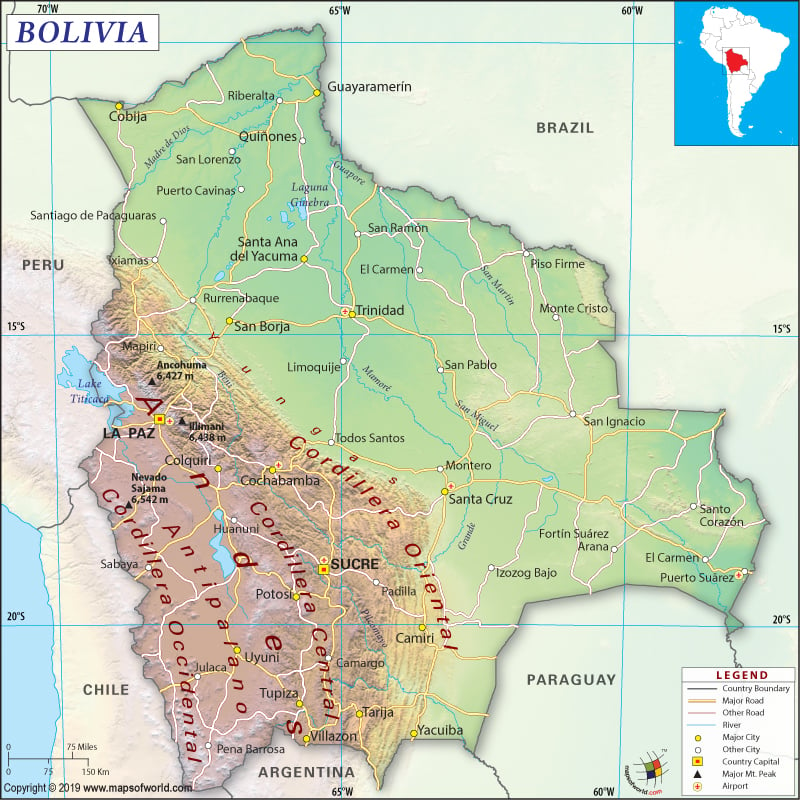
Where is Bolivia?
Bolivia is a Central South American country that is located to the southwest of Brazil. This landlocked country shares 7,252 km (4506 mi) border with five neighboring countries: Brazil (3,403 km or 2,115 mi), Peru (1,212 km or 753 mi), Argentina (942 km or 585 mi), Chile (942 km or 585 mi), and Paraguay (753 km or 468 mi).
What is the Geography of Bolivia?
Bolivia is spread across a total area of 1,098,581 sq. km (424,165 sq. mi), of which 1,083,301 sq. km (418,265 sq. mi) is land and the rest 15,280 sq. km (5,900 sq. mi) is water. However, Bolivia doesn’t have any coastline.
At the same time, Bolivia not only exhibits a great variation in its geography (terrains and climates) but also a significantly high level of biodiversity. There are many ecoregions in the country having a wide array of ecological sub-units. The biodiversity includes Amazon’s tropical rainforest, Altiplano, tropical savanna called Chiquitania, and dry valleys.
Similarly, the altitude variation is also enormous. While Nevado Sajama is the highest elevation point at 6,542 m (21,463 ft), Rio Paraguay is the lowest point at 90 m (295 ft). The mean elevation stands at 1,192 m (3,911 ft).
Broadly, the physical geography of Bolivia can be divided into 3 main regions: Llanos region, Andean region, and Sub-Andean region.
The Llanos region (located at an elevation of less than 400 m or 1,300 ft) is spread across an area of 648,163 sq. km (250,257 sq. mi). It occupies around 59% of the total Bolivian territory of the country. This region features flat land and small plateaus that are covered by extensive rain forests.
The Andean region (located at an elevation of more than 3,000 m or 9,800 ft) is the largest physiographic region of Bolivia. Some of the highest elevation points in Bolivia are located in this region such as Nevado Sajama, Illimani, the world’s highest commercially navigable lake (Lake Titicaca), the world’s largest salt flat (the Salar de Uyuni), and Altiplano. This Andean region is spread across an area of 307,603 sq. km (118,766 sq. mi), occupying around 28% of the total Bolivian territory.
The Sub-Andean region encompasses the Bolivian valleys as well as the Yungas region. It is the intermediate region located within the eastern llanos (plain) and the Altiplano. It is spread across an area of 142,815 sq. km (55,141 sq. mi). The characteristic features of this region are temperate climate as well as farming activities.
The climatic varies significantly from one eco-region to the other. While tropical climate can be found in the eastern llanos, a polar climate can be found in the western Andes. There are three main climatic conditions. The western parts have a drier climate. The eastern parts are humid. The summers in Bolivia are generally warm. El Niño effect can change the weather drastically. The western parts of the country have very cold winters and the mountain ranges get snow. The places in the western region of Bolivia commonly get windy days. The non-tropical regions get dry autumn.
A humid tropical climate is found in the Llanos region, where the average temperature revolves around 25 °C (77 °F). Significant rainfall is caused by the wind blowing from the Amazon rainforest. However, dry winds blow in the month of May, causing low temperature.
The Desert-Polar climate is found in the Altiplano. This climate is characterized by strong and cold winds with an average temperature ranging from 15 °C to 20 °C. The temperature falls close to 0 °C during the nighttime. The solar radiation remains high during daytime and weather remains dry. Snowfall takes place frequently and ground frosts take place every month.
The subtropical semi-arid climate is found in Gran Chaco. The month of January remains rainy as well as humid. The days remain warm and nights cold during the rest of the year. A temperate climate is found in the Valleys and Yungas.
What is the Economy of Bolivia?
During 2004-2014, the Bolivian economy grew at an average annual rate of 4.9%. This significant growth has been possible due to the prudent macroeconomic policy, export expansion of natural gas, and high commodity prices. The consistent economic growth has helped in bringing down the moderate poverty level during this one decade from 59% to 39%. In 2018, the nominal GDP of the country was US$40.29 billion, and the economy grew at a rate of 4.22%. The share of services in the GDP is at 48%, industry 38% and agriculture 13%. However, the participation of the state in the strategic sectors remains high, though efforts are on to increase foreign direct investment and private sector participation. With sustained efforts, the moderate poverty rate has further come down to 35% in 2018. The IMF has lauded Bolivia for maintaining a growth rate of more than 4% (which is one of the highest among the Latin American countries) and at the same time reducing poverty significantly.
What is the Transportation System of Bolivia?
Bolivia has a 90,568 km (56,276 mi) of total roadways, out of which most are unpaved (80,776 km or 50,192 mi). 9,792 km (6,084 mi) are paved roadways. There are 855 airports present in Bolivia, out of which 21 airports have paved runways and 834 have unpaved runways. The country has 10,000 km (6,214 mi) of commercially navigable waterways with 49 merchant marine ships. Narrow gauge railways of 3,960 km (2,461 mi) are also available.
What International Organizations is Bolivia part of?
Union Latina, FAO, WTO, CAN, UN, CD, CELAC, UNESCO, G-77, WHO, IADB, IAEA, IBRD, ICAO, UNCTAD, ICCt, UNIDO,ICRM, IDA, IFAD, IFC, IFRCS, ILO, IMF, IMO, Interpol, IOC, IOM, IPU, ITSO, ITU, LAES, LAIA, MIGA, MINUSTAH, MONUSCO, NAM, OAS, OPANAL, OPCW, PCA, UNAMID, UNASUR, UNMIL, UNMISS, UNOCI, UNWTO, UPU, WCO, WFTU (NGOs), WIPO, WMO, ICC (national committees), Mercosur (associate), ISO (correspondent), UN Security Council (temporary)

