Tropical Storm
Tropical Storm is a low pressure centered powerful wind system with a speed of 39 mph or above. As its speed intensifies this wind system becomes tropical cyclone or hurricane. Tropical storm is a strong thunderstorm that develops as a tropical depression and eventually with higher speed become tropical cyclone. The tropical storm though is not as furious as a hurricane or tropical cyclone, but can cause small scale damages. The storm can cause damages to power lines, mobile roofs, etc. Even inland flooding can happen due to rain after the storm.
Tropical Cyclone
When a Tropical Storm matures and its intensity and speed reaches 74mph or above it become a Tropical Cyclone or a hurricane or a typhoon depending on its location. Tropical cyclones are called so because of their origin on the tropical seas. This low pressure system forms in the tropics over warm tropical waters with an eye in the center. The diameter of the eye ranges between 10 km to 100 km and the surrounding eye wall, which is a thick ring of cloud, rises about a height of 16 km. Tropical Cyclones are formed by the energy derived from the warm tropical oceans with temperature above 26.5°C. The tropical cyclones can stay for many days once formed and generally follow erratic paths. The tropical cyclones are associated with heavy rains, thunderstorms, and high waves. The cyclones blow counterclockwise in the Northern hemisphere and clockwise south of the equator. Tropical cyclones form frequently in the late summer season, when the temperature difference between the sea surface and the air above is at its maximum.
Few of the Recent Tropical Cyclones in the Indian Ocean
Tropical cyclones are named to distinguish one from the other. The naming of the cyclones in the Indian Ocean is done by panel member countries (countries surrounding Indian Ocean). The list of names is prepared long before the appearance of the cyclones.
Cyclone Hudhud, 2014, is a category 4 cyclone based on Saffir-Simpson wind scale, which formed in the north of Indian Ocean on 7 October and dissipated by 14 October. Cyclone Hudhud reached its maximum intensity with wind speed of 115 mph and lowest pressure of 950 mbar. This cyclone killed about 109 people and caused damages worth US$ 11 billion. The areas affected mainly by this cyclone were Andhra Pradesh, Odisha, Andaman and Nicobar Island.
Cyclone Phailin, 2013, a category 5 cyclone based on Saffir-Simpson wind scale, emerged in the Gulf of Thailand as a depression before moving to Andaman Sea, Andaman and Nicobar Island, and into Bay of Bengal as a cyclonic storm affecting countries like Thailand, Myanmar, and eastern part of India. This cyclone was formed on 4 October and dissipated by 14 October’ 2013. The cyclone claimed 45 lives and caused damages worth US$ 696 million. This cyclone reached its peak with wind intensity of 130 mph and lowest pressure of 940 mbar.
Cyclone Giovanna, 2012, an intense category 4 cyclone, is also the first severe tropical cyclone to affect Madagascar killing 33 people at its coast. This cyclone appeared on 7 February and dissipated by 24 February after reaching its highest wind intensity of 120 mph and lowest pressure of 935 mbar. Beside Madagascar, this tropical cyclone of southwest Indian Ocean, also affected La Reunion and Mauritius and caused 35 causalities.
Cyclone Bruce, 2013, was a severe category 3 cyclone that developed over eastern Indian Ocean on 16 December and dissipated by 19 December. This tropical cyclone reached its maximum intensity with 100 mph and pressure of 961 mbar. It affected parts of southwest Indonesia, Western Australia, and Cocos Islands, but no major damage or causality was reported.
Preventive Measures
The best preventive measure is to keep vigilant watch and provide warning to the occupants of potential disaster zones in advance, so that necessary precautions can be taken. Besides, the cyclone potential coastal areas as well as other cyclone risk areas should have proper plantation, so that impact of post cyclone floods can be controlled. Also, dams, embankments on the coast should be well maintained so as to control the surging storm associated with a cyclone. Proper prevention can minimize the possible damages related with a heavy storm.
 |
 |
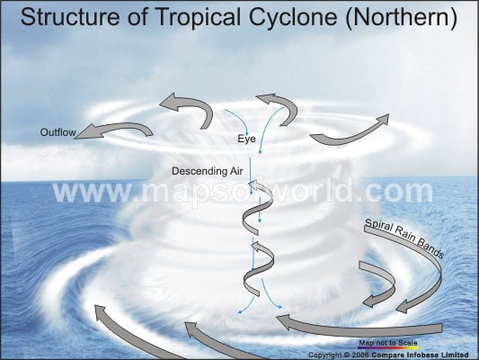
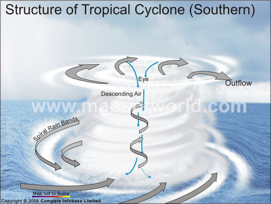
- A low pressure core around which the tropical cyclone rotates. The low pressure at the center of the tropical cyclone is amongst the lowest that occur on Earth’s surface at sea level. For some cyclones the pressure dips below 900 mb, and these are the most devastating tropical cyclones.
- At the center of the cyclones the temperature is greater than the surroundings. A warm core is formed as a result of condensation of the upward rising moist air, that releases latent heat of condensation.
- All cyclones have a Central Dense Overcast (CDO). A CDO is a dense shield that contains the eye and the eyewall of the tropical cyclone. The classic tropical cyclone contains a symmetrical CDO, i.e. it is perfectly circular and round on all sides. This is the zone where maximum activity occurs.
It is composed of large number of thunderstorms arranged in a pinwheel formation with thick clouds spiraling around the storm center popularly known as the “eye”.
- An eye of the cyclone is most remarkable and characteristic feature of all tropical cyclone. It is the area of sinking air at the center of circulation. The eye is characterized by clear skies and calm weather. It is circular in shape and in size ranges from 8 – 200 km.
- The eyewall is the band around the eye with maximum wind speed, heaviest rainfall and greatest height. It is responsible for the maximum damage caused by a cyclone.
- At the upper level of tropical cyclone winds move away from the center resulting in anticyclonic rotation.
- In a tropical cyclone, the rainbands are oriented in the same direction as the horizontal winds and it seems to spiral into the center of the tropical cyclone. These bands are known as spiral bands.
 How is a Tropical Cyclone formed