1.7K
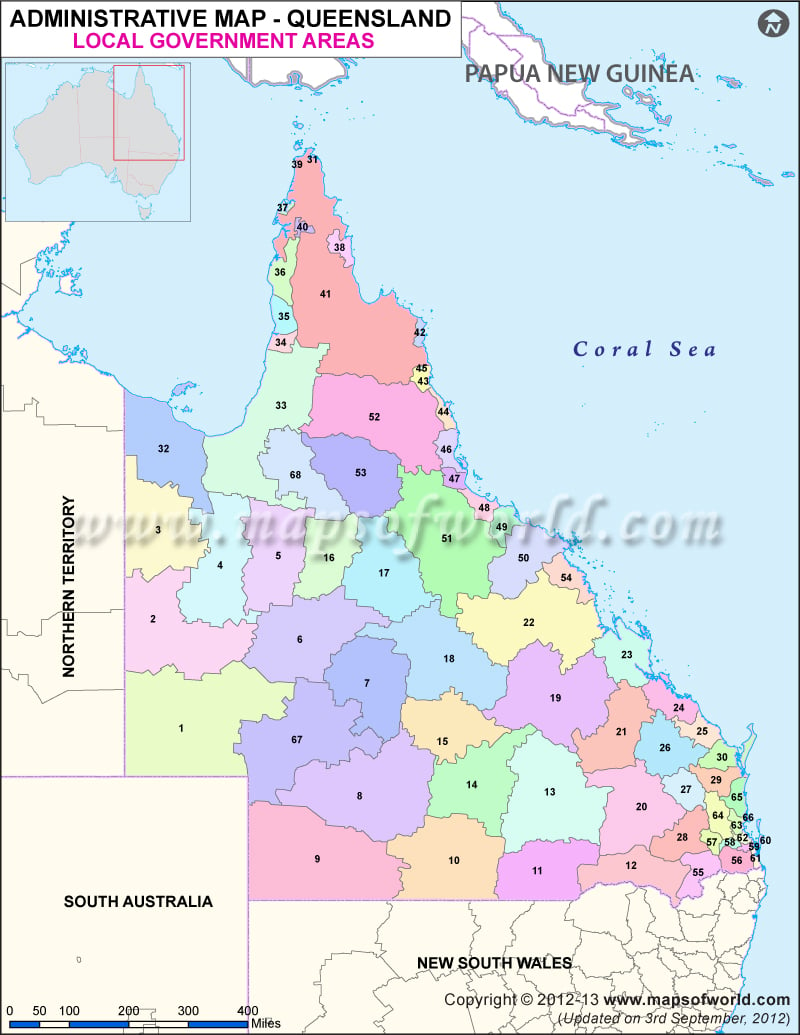
| NUMBER | NAME | NUMBER | NAME |
|---|---|---|---|
| 1 | Aurukun | 35 | Lockhart River |
| 2 | Balonne | 36 | Lockyer Valley |
| 3 | Banana | 37 | Logan City |
| 4 | Barcaldine | 38 | Longreach Region |
| 5 | Barcoo | 39 | Mackay |
| 6 | Blackall-Tambo | 40 | Mapoon |
| 7 | Boulia | 41 | Maranoa |
| 8 | Bribie Island | 42 | Mckinlay |
| 9 | Bulloo | 43 | Moreton Bay |
| 10 | Bundaberg | 44 | Mount Isa |
| 11 | Burdekin | 45 | Murweh |
| 12 | Burke | 46 | Napranum |
| 13 | Cairns | 47 | North Burnett |
| 14 | Carpentaria | 48 | Northern Area |
| 15 | Cassowary Coast | 49 | Paroo |
| 16 | Central Highlands | 50 | Pormpuraaw |
| 17 | Charters Town | 51 | Quilpie |
| 18 | City of Brisbane | 52 | Redland City |
| 19 | Cloncurry | 53 | Richmond |
| 20 | Cook | 54 | Rockhampton |
| 21 | Croydon | 55 | Scenic Rim |
| 22 | Diamantina | 56 | Somerset |
| 23 | Etheridge | 57 | South Burnett |
| 24 | Flinders | 58 | Southern Downs |
| 25 | Fraser Coast | 59 | Sunshine Coast |
| 26 | Gladstone | 60 | Tablelands |
| 27 | Gold Coast City | 61 | Toowoomba |
| 28 | Goondiwindi | 62 | Torres |
| 29 | Gympie | 63 | Townsville |
| 30 | Hinchinbrook | 64 | Western Downs |
| 31 | Hope Vale | 65 | Whitsunday Region |
| 32 | Isaac | 66 | Winton |
| 33 | ity of Ipswich | 67 | Wujal Wujal |
| 34 | Kowanyama | 68 | Yarrabah |
