What is Aegean dispute between Greece and Turkey?
The Aegean Sea is unique in holding several islands that lie between two ancient countries Greece and Turkey, which have been at the root of the prolonged tension between the two.
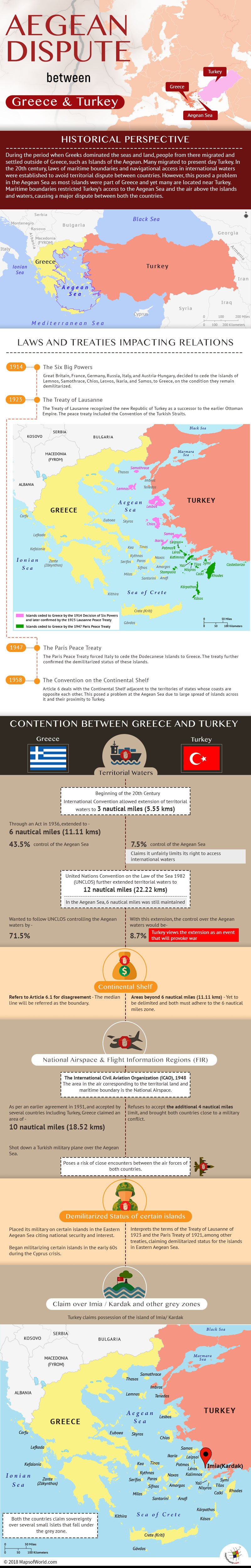
Historical perspective
During the period when Greeks dominated the seas and land, people used to migrate and settle outside of Greece and Islands of the Aegean were among the several places where Greeks settled. Many also migrated to present day Turkey, settling along the coastal areas.
The rise of the Ottoman Empire in Turkey in 13th century saw the Ottomans assert themselves, dominating other communities including the Greeks. However, most islands of the Aegean continued to be home to many Greeks and they largely remain a part of Greece till this day.
In the 20th century, laws of maritime boundaries and navigational access in international waters were established to avoid territorial dispute and conflict between countries. The universally applicable laws presented a unique problem in the Aegean Sea. Most islands form part of Greece, and many others are located nearby the Turkish mainland. The maritime boundaries, if universally applied, severely restrict Turkey’s access to the Aegean Sea, a major point of dispute. Access to the air above the islands and territorial waters, is another point of dispute between the two countries.
The islands of the Aegean Sea with Greece
- Thasos
- Samothrace
- Imbros
- Lemnos
- Tenedos
- Lesbos
- Chios
- Imia (Kardak)
- Kalolimnos
- Kalimnos
- Farmakonisi
- Lipsos
- Leros
- Kalimnos
- Pserimos
- Kos
- Yali
- Nisiros
- Samos
- Rhodos
- Crete
These islands belonging to Greece are spread across the Aegean Sea, and many lie closer to the Turkish mainland than Greece.
Major issues of dispute between Greece and Turkey in the Aegean Sea
- The delimitation of the territorial waters.
- The delimitation of the national airspace.
- The use of Continental shelf and the delimitation of Exclusive Economic Zones (EEZ).
- The delimitation of Flight Information Regions (FIR) and their significance for the control of military flight activity.
- The demilitarized status accorded to some of the Greek islands in the area.
- Turkish claim on the island of Imia which it refers as Kardak, along with several small islets close to the Turkish mainland.
Laws and treaties impacting relations between Greece and Turkey
The decision of Six powers of 1914
In 1914, the Six Big Powers – Great Britain, France, Germany, Russia, Italy, and Austria-Hungary, decided to cede the islands of Lemnos, Samothrace, Chios, Lesvos, Ikaria, and Samos along with other islands in the Aegean, to Greece, on the condition that they remain demilitarized.
The Treaty of Lausanne or the Lausanne Peace Treaty of 1923
The Treaty of Lausanne recognized the new Republic of Turkey as successor to the earlier Ottoman Empire. The peace treaty included the Convention of the Turkish Straits, confirming the demilitarized status of specified islands in the Aegean.
The Paris Peace Treaty of 1947
The Paris Peace Treaty of 1947 forced Italy to cede the Dodecanese Islands (Stampalia, Rhodes, Scarpanto, Calki, Casos, Symi, Piscopis, Castellorizo, Leros, Patmos, Nisiros, Lipsos, Cos, and Calimnos) to Greece. The treaty further confirmed the demilitarized status of these islands.
The Convention on the Continental Shelf 1958
Article 6 (6.1, 6.2, 6.3) deals with the Continental Shelf adjacent to the territories of two or more states whose coasts are opposite each other. While universally applied, the Aegean Sea presents a unique problem given the large spread of islands across the sea and the proximity of many islands to the Turkish mainland.
The points of contention between Greece and Turkey
Territorial Waters
At the beginning of the 20th Century, international convention allowed the width of territorial waters to extend 3 nautical miles (5.55 kms). Greece, through an Act in 1936, extended its territorial waters to 6 nautical miles (11.11 kms). The action gave Greece control of 43.5% of the Aegean Sea, leaving Turkey with 7.5%. Turkey claims it unfairly limits its right to access international waters.
With demands for commercial exploitation of the sea and submarine zones, the territorial waters were further extended to 12 nautical miles (22.22 kms) as confirmed by the United Nations Convention on the Law of the Sea 1982 (UNCLOS).
However, in the Aegean Sea, the territorial waters are still maintained at 6 nautical miles (11 kms). Greece wants to follow UNCLOS and extend its territorial waters to 12 nautical miles (22.22 kms). If extended, Greece would end up controlling 71.5% of the Aegean waters leaving Turkey with 8.7%. International waters would reduce from 49% to 19.7%. Turkey views the extension as casus belli, an event that will provoke war.
Continental Shelf
Greece refers to Article 6.1 stating in case of disagreement between states, that the median line will be the referred as the boundary.
Turkey states the Continental Shelf areas beyond 6 nautical miles (11.11 kms) is yet to be delimited. Hence, both countries must continue to adhere to the 6 nautical miles zone.
National Airspace
The International Civil Aviation Organization (ICAO) of 1948, defined national space as the area in the air corresponding to the territorial land and maritime boundary of a country. As per this definition, the national airspace of Greece should be within the 6 nautical mile area. However, Greece has claimed 10 nautical miles (18.52 kms) of airspace referring to an earlier agreement signed in 1931, and accepted by several countries including Turkey, allowing Greece to maintain national airspace at 10 nautical miles (18.52 kms).
Turkey refuses to accept the additional 4 nautical mile limit, and it has brought both countries close to a military conflict over this. In 1996, Greece shot down a Turkish military plane over the Aegean Sea. Close encounters between the air forces of both countries are regular and dangerous.
Flight Information Regions (FIR)
International law on aviation allows the state to control FIR in the air space above its territory and authorizes the state to provide flight information and alert services to all aircraft flying above its territory. Turkey’s refusal to accept the 10 nautical miles (18.52 kms) territory above Greece’s island poses a risk of accident and remains a major point of contention between the two littoral states.
Demilitarized Status of certain islands
Greece has placed its military on certain islands in the Eastern Aegean Sea, citing national security and interest. Greece began militarizing certain islands in the early 60s during the Cyprus crisis.
Turkey interprets the terms of the Treaty of Lausanne of 1923 and the Paris Treaty of 1921, among other treaties, claiming demilitarized status for the islands in Eastern Aegean Sea.
Claim over Imia / Kardak and other grey zones
The islets of Imia / Kardak (Turkey refers to it as Kardak) measuring 10 acres (4.0 hectares) lie 2.5 nautical miles (4.63 kms) southeast of the Greek island of Kalolimnos and 2.5 nautical miles off the coast of Bodrum in Turkey.
In 1996, an incident regarding a Turkish boat running aground in the Imia waters, led to claims of sovereignty by both countries, a status that remains unresolved to this day and remains yet another cause for rising tensions between the two countries.
Several small islets fall under the ‘grey zone,’ and both countries claim sovereignty over them.
Know more about world disputes:
Related Maps:

