What are the Key Facts of South Dakota?

|
State |
South Dakota |
|
State Capital |
Pierre |
|
Largest City |
Sioux Falls |
|
Coordinates |
44.5°N 100°W |
|
Nickname(s) |
“The Mount Rushmore State” (official) |
|
Postal Abbreviation |
SD |
|
Area |
77,116 sq. mi (199,729 sq. km) |
|
Highest Point |
Black Elk Peak, 7,244 ft (2,208 m) |
|
Neighboring States |
North Dakota, Montana, Iowa, Wyoming, Minnesota, Nebraska |
|
Number of Counties |
66 |
|
Population |
884,659 (2019) |
|
Date of Entering the Union |
November 2, 1889 |
|
State Anthem |
“Hail, South Dakota!” |
|
Governor |
Kristi Noem (Republican) |
|
Lieutenant Governor |
Larry Rhoden (Republican) |
|
U.S. senators |
John Thune (Republican), Mike Rounds (Republican) |
|
U.S. House Delegation |
Dusty Johnson (Republican), John Thune (Republican), Mike Rounds (Republican) |
|
GDP (millions of dollars) |
54,057 |
|
Demonym |
South Dakotan |
|
Time Zones |
eastern half UTC−06:00 (Central), Summer (DST) UTC−05:00 (CDT); western half UTC−07:00 (Mountain), Summer (DST) UTC−06:00 (MDT |
Where is South Dakota?
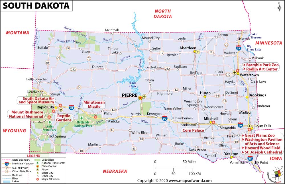
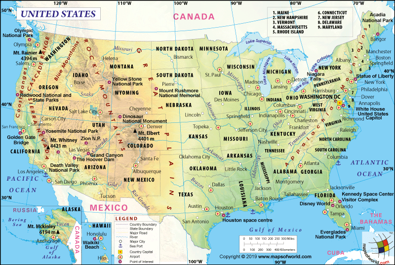
South Dakota lies in the north-central United States of America, and the state is considered a part of the Midwestern region of the USA. It is the 39th or 40th state admitted to the Union on November 2, 1889. North Dakota surrounds South Dakota to the north, Minnesota to the east. Iowa also bounds it to the southeast, Nebraska to the south, Wyoming to the west, and Montana to the northwest.
What is the Geography of South Dakota?
South Dakota spreads across a total area of 77,116 sq. mi (199,729 sq. km), out of which 75,811 sq. mi (196,350 sq. km) is land area and 1,305 sq. mi (3,379 sq. km) is the water area. Water bodies constitute 1.7 % of the total area. South Dakota is in 17th rank in terms of area in the U.S.
The state has an abundance of rivers, and some of the prominent rivers are- Little Minnesota River, James River, White River, Jorgenson River, Whetstone River, Grand River, Rapid Creek, Castle Creek, Belle Fourche River and many more. The longest river of the state is Missouri River; its length is 2,340 miles while James River and White River are on the second and third spots, respectively.
The state’s mean elevation is 2,200 ft (670 m) above sea level. The highest elevation point of the state is Black Elk Peak which is 7,244 ft (2,208 m) while the lowest elevation point of South Dakota is Big Stone Lake on Minnesota border which is 968 ft (295 m).
South Dakota divides into three geographic regions- eastern South Dakota, western South Dakota, and the Black Hills. The state is known for four major land regions, such as the Drift Prairie, the Dissected Till Plains, the Great Plains, and the Black Hills.
Drift Prairie covers a big part of eastern South Dakota. The Dissected Till Plains covers the southeastern corner of the state. The Great Plains cover most of the western 2/3 of South Dakota. At the same time, the Black Hills are the area of the southwestern part of the state.
There are a significant number of mountains in South Dakota, such as- Black Elk Peak, Dakota Mountain, Bear Mountain, Green Mountain, Terry Peak, White Mountain, and many more. Black Elk Peak is the tallest mountain of South Dakota.
Forest covers a large part of the land of South Dakota. Black Hills National Forest is in the southwestern area of the state and northeastern Wyoming. It has an area of over 1.25 million acres (5,066 km²), which is managed by the Forest Service of the state. The Black Hills are known for several precious trees like-ponderosa pine, quaking aspen, bur oak, white spruce, and paper birch.
The state is home to several animals, including black-tailed prairie dogs, black-tailed jackrabbit, mule deer, pronghorn, bison, coyotes, bighorn sheep, and many more. Many lovely birds are also spotted in South Dakota, such as Red-necked Grebe, Western Grebe, American Bittern, Northern Harrier, Upland Sandpiper, Marbled Godwit, and many more.
White spruce is the state tree of South Dakota, while the American Pasque flower is the state’s flower. Besides, this coyote is the state animal of the state, and Ring-necked Pheasant is the state bird of South Dakota.
What is the Climate of South Dakota?
The state has a temperate continental type of climate. South Dakota experiences warm and humid summers. In comparison, the winters are dry and cold. The Missouri River separates the state into two parts- western and eastern parts known as West River and East River.
The temperature of the state during summer is variable. The average summer temperature remains 80°F (26.7°C) to 90°F (32.2°C). Semi-arid and western belts experience 100°F (37.8°C) for several days during hot and dry spells. Winters are cold in the state. The high temperature in winter varies between, 25°F (-3.9°C) to 45°F (7.2°C) while the average low temperature in severe winter in South Dakota remains between 5°F (-15°C) to 19°F (-7.2°C). July and January are the hottest and coldest months of the state, respectively. It also experiences thunderstorms and tornadoes, especially in the southeastern area of the state during late spring and early summer.
The state receives an average annual rainfall of 20 inches (508mm). The southeastern part of the state gets an annual rainfall of 25 inches (635mm) while the Black Hills receive above 30 inches (762mm) of annual rainfall. Mountain ranges of South Dakota experience annual snowfall above 100 inches (2540mm) while plains get snow during winter.
What is the Economy of South Dakota?
Agricultural production plays a crucial role in the economy of South Dakota, but tourism, forestry, and mining are other vital sectors of the state’s economy. It is undeniable that agriculture is the lifeblood of the state. As per the 2017 census of agriculture, farmers and ranchers made a considerable profit and sold agricultural products worth more than $10 billion.
South Dakota is famous for the cultivation of corn, alfalfa, rye, flaxseed, wheat, and soybeans. The state is the leading cattle producer in the United States. The state has a respectable place in the production of beef cattle, chicken, eggs, geese, and turkeys. Therefore, the income from livestock products is generated more than that from crops. The state is famous for the manufacturing of wood products, light machinery, computers, electronic products, and so on.
The total Gross Domestic Product (GDP) of the state was the U.S. $ 53,305.7 in 2019, while the per capita personal income of South Dakota was 53,925 US dollars in 2019.
What is the Transportation System of South Dakota?
Public roadways of the state are maintained by the South Dakota Department of Transportation (SD DOT). Two prominent interstate highways pass through the state: Interstate 90, which runs from east to west and Interstate 29, runs north and south in the eastern part of the state. Some other mainline highways of the state are- 1-29, 1-90, 1-190, 1-229, and so on.
Railroads play a vital role in South Dakota transportation. At present BNSF Railway is the largest railroad in the state. Some of the major freight carriers of the state are-D&I Railroad (DAIR), Dakota, Missouri Valley and Western Railroad (DMVW), Dakota Southern Railway (DSRC), etc.
The state is well-connected by air. The two biggest airports of the state in terms of passenger traffic are the Sioux Falls Regional Airport and Rapid City Regional Airport. Joe Foss Field is the most significant international airport in South Dakota.
What is the Origin of the Name of “South Dakota”?
The meaning of Dakota is “friend” or “allies.” The Dakota word emerged because the Sioux tribe used to live in this region. Dakota itself is a Sioux word In the Native American Sioux language. North and South Dakota were one territory but separated in 1889.
Why is South Dakota Called “Mount Rushmore State”?
The official nickname of the state is “Mount Rushmore State” This name was designated to South Dakota in 1992, in honor of mountain carving of U.S. presidents in the Black Hills. The nickname Mount Rushmore has been featured in the U.S. Mint’s bicentennial commemorative quarter for South Dakota.
It is also known by some other nicknames such as “Coyote State,” “Swinged Cat,” “The Artesian State,” “The Blizzard State”, and “The Sunshine State”.
What are the Popular Tourist Attractions in South Dakota?
South Dakota’s landscape attracts tourists a lot. The state is replete with several fantastic tourist attractions such as Mount Rushmore National Monument, Badlands National Park, Custer State Park, Crazy Horse Memorial, Wind Cave National Park, Black Hills National Forest, and Mammoth Site, Deadwood, Spearfish Canyon, National Music Museum and many more. Apart from these tourists have lots of things to watch and enjoy every bit of their time in South Dakota.
Facts About South Dakota
1.Arikara were the first indigenous Americans to have resided in South Dakota.
2.Most of the members of Sioux tribe are residents of the state
3.Mammoth Site is held in high regard in scientific circles as it houses the remains of many mammoths.
4.The state was taken over by USA in 1803 through the Louisiana Purchase.
5.The state has been named after the prominent Native American race of the region – the Sioux.
6.Spearfish stages Black Hills Passion Play, a famous yearly event.
7.It was in 1743 that Francois Verendrye and Louis-Joseph started to survey the region.
8.The ring-necked pheasant is South Dakota’s official bird.
9.During the mid 90s, at least 90% of the land area in South Dakota was categorized as agricultural land.
10.After Sitting Bull’s death, his horse became a part of the Wild West Show run by Buffalo Bill. He showed most of the tricks that he learnt from his master at these events.
11.It was on 2nd November in 1889 that South Dakota gained statehood. It was preceded by 39 others.
12.South Dakota houses 8 reservations meant for Indian Americans.
13.A church located in Green Islands was cleaned up as it is during the 1881 flood,
14.The state is also home to the Mount Rushmore National Memorial.
15.Mitchell houses the Corn Palace, which is a globally known monument.
16.The Badlands National Park has proof of evolution that has gone on for thirty five million years.
17.In the areas that lie to Rockies’ east, the tallest mountain range is Black Hills.
18.Almost 50% of the state’s residents stay in farms.
19.Homestake Mine is located in Lead. It is among the biggest gold pits in the region.
20.In 1817 the Fort Pierre was set up. It was the earliest permanent residence of the area.


