2.3K
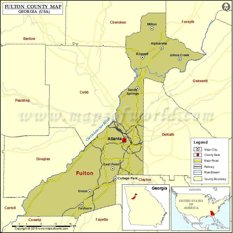
Check this Georgia County Map to locate all the state’s counties in Georgia Map.
Mountain Peaks in Fulton County
| Mountain Peak/Hill | Elevation [Meter] |
|---|---|
| Dabneys Hill | 316 |
More Maps of Fulton County
Airports in Fulton County
| Airport Name |
|---|
| Bermuda Dunes Airport |
| Bridge Building Heliport |
| Children Health Care Atl At Scottish Rite Heliport |
| Crawford W. Long Memorial Hospital Heliport |
| Emory Johns Creek Hospital Heliport |
| Fort Mcpherson Heliport |
| Fulton County Airport Brown Field |
| Grady Memorial Hospital Heliport |
| Hartrampf Heliport |
| Hilton Garden Inn Downtown Heliport |
| Legacy Medical Center Heliport |
| Morgan Falls Heliport |
| Northside Hospital Heliport |
| Rollins STOLport |
| Roswell Animal Hospital Heliport |
| Ruffwood Heliport |
| Saint Joseph’s Hospital Heliport |
| Sheepy Hollow Ranch Airfield |
| Skypad Heliport |
| Skypad Heliport |
| South Fulton Airport |
| South Fulton Medical Center Heliport |
| Stonewall Heliport |
| The Coca-Cola Company Heliport |
Cities in Fulton County
| City | Population | Latitude | Longitude |
|---|---|---|---|
| Alpharetta city | 57551 | 34.070383 | -84.273828 |
| Atlanta city | 420003 | 33.762652 | -84.423142 |
| Chattahoochee Hills city | 2378 | 33.560472 | -84.751205 |
| College Park City | 13942 | 33.638439 | -84.459723 |
| East Point city | 33712 | 33.669636 | -84.469966 |
| Fairburn city | 12950 | 33.549708 | -84.59153 |
| Hapeville city | 6373 | 33.660874 | -84.409321 |
| Johns Creek city | 76728 | 34.033299 | -84.20272 |
| Milton city | 32661 | 34.13534 | -84.313796 |
| Mountain Park city | 547 | 34.083027 | -84.413329 |
| Palmetto city | 4488 | 33.532078 | -84.668492 |
| Roswell city | 88346 | 34.039138 | -84.351223 |
| Sandy Springs city | 93853 | 33.936667 | -84.37032 |
| Union City city | 19456 | 33.594204 | -84.561 |
Golf Courses in Fulton County
| Name of Golf Course | Latitude | Longitude |
|---|---|---|
| Alfred ‘Tup’ Holmes Golf Course-Atlanta | 33.714826 | -84.463962 |
| Alpharetta Athletic Club East-Alpharetta | 34.127274 | -84.259348 |
| Alpharetta Athletic Club West-Alpharetta | 34.151993 | -84.311841 |
| Ansley Golf Club-Atlanta | 33.800299 | -84.375472 |
| Atlanta Athletic Club-Johns Creek | 34.00497 | -84.193706 |
| Atlanta National Golf Club-Alpharetta | 34.126508 | -84.350943 |
| Bobby Jones Golf Course-Atlanta | 33.817311 | -84.401192 |
| Brookfield Country Club-Roswell | 34.076492 | -84.401923 |
| Browns Mill Golf Course-Atlanta | 33.681601 | -84.369616 |
| Capital City Club Brookhaven-Atlanta | 33.862876 | -84.349965 |
| Cherokee Town & Country Club-Atlanta | 33.991228 | -84.360893 |
| College Park Municipal Golf Course-College Park | 33.654294 | -84.464141 |
| Country Club of Roswell-Roswell | 34.022543 | -84.285938 |
| Country Club of the South-Johns Creek | 34.017355 | -84.23936 |
| Cross Creek Golf Course-Atlanta | 33.815591 | -84.42389 |
| Dunwoody Country Club-Atlanta | 33.96524 | -84.312723 |
| Durham Lakes Country Club-Fairburn | 33.561747 | -84.61093 |
| Horseshoe Bend Country Club-Roswell | 33.98476 | -84.289967 |
| John A. White Golf Course-Atlanta | 33.726727 | -84.446324 |
| Manor Golf and Country Club-Alpharetta | 34.168606 | -84.261283 |
| North Fulton Golf Course-Atlanta | 33.87568 | -84.391789 |
| Piedmont Driving Club Golf Course-Atlanta | 33.661917 | -84.537917 |
| Rivermont Golf & Country Club-Alpharetta | 34.001 | -84.264277 |
| RiverPines Golf Course-Alpharetta | 34.012246 | -84.221568 |
| St Ives Country Club-Duluth | 34.028102 | -84.182221 |
| Steel Canyon Golf Club-Atlanta | 33.96961 | -84.370027 |
| The Golf Club of Georgia-Alpharetta | 34.087604 | -84.22017 |
| The Golfers’ Club At Fort McPherson-Fort McPherson | 33.705988 | -84.441605 |
| The Standard Club-Duluth | 34.051073 | -84.183962 |
| The White Columns Country Club-Alpharetta | 34.153298 | -84.329619 |
| Trophy Club of Atlanta-Alpharetta | 34.145533 | -84.286323 |
| Wolf Creek Golf Course-Atlanta | 33.681789 | -84.579921 |
National Parks in Fulton County
| Name of Park | Latitude | Longitude |
|---|---|---|
| Chattahoochee River NRA | 34.00998 | -84.226192 |
| Chattahoochee River NRA | 33.986171 | -84.372118 |
| Chattahoochee River NRA | 33.920187 | -84.417107 |
| Martin Luther King, Jr. NHS | 33.754928 | -84.371998 |
 Wall Maps