
- Nearby National Parks - Joshua Tree National Park, Sequoia and Kings Canyon National Parks
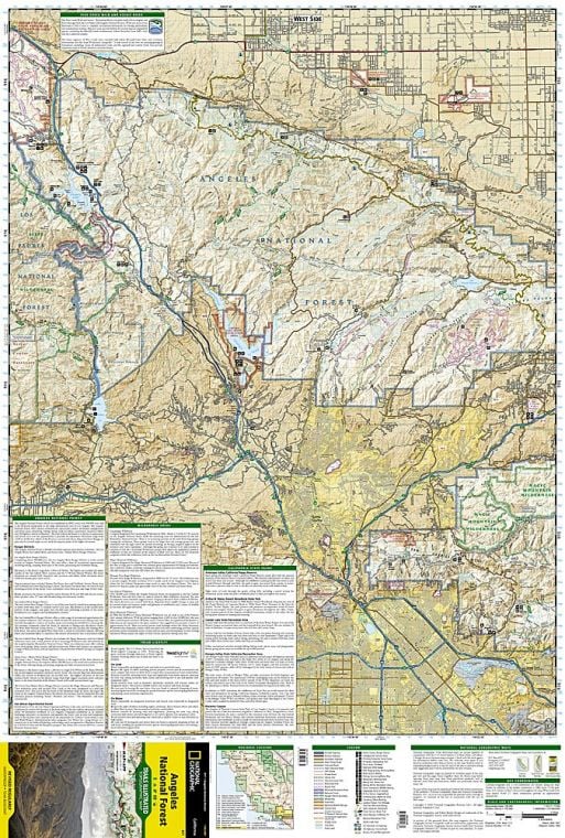
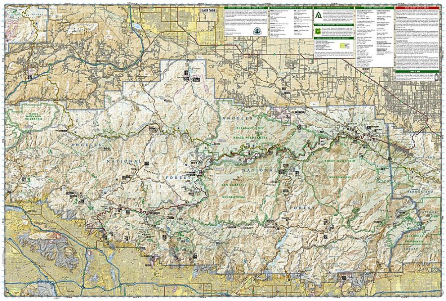
Angeles National Forest
The National Forest is in southern California, mainly in Los Angeles, and its headquarter is in Arcadia. You can take your pet dog along with you, but keep it under a leash.
Places to Visit Nearby
- Santa Anita Race Park
- Los Angeles County Arboretum & Botanic Garden
- Winter Creek Loop
- Wilderness Areas:
- Cucamonga
- Magic Mountain
- Pleasant View Ridge
- San Gabriel Wilderness
- Sheep Mountain Wilderness
- Buckhorn Campground
Things to Do
- Sand Play on beaches and dunes
- Mountain Biking
- Camping:
- Campground Camping
- Group Camping
- RV Camping
- Horse camping
- Relax at cabin rentals
- River and Stream Fishing
- Backpacking and Day Hiking
- Horse riding
- OHV Trail Riding
- Outdoor Learning:
- Interpretive Areas
- Visitor Centers
- Visitor Programs
- Picnicking
- Water Activities:
- Swimming
- Non-motorized boating
- Winter Sports
- Cross-country skiing
- Snow camping
- Hiking
- Snowmobiling
- Snow playing
- Target Shooting
Hikes
Angeles National Forest offers you a wide range of trails, ranging from moderate to challenging ones. Some of the most notable ones are the incredibly scenic Throop Peak, Switzer Falls hike to a waterfall, Bridge to Nowhere trail, and many more.
Top 5 Angeles National Forest Trails
-
Mount San Antonio and Mount Baldy Notch Trail
The trail is a strenuous 17.7 km (11 mi) long loop trail near California’s Mount Baldy. It will take you around 7 hours on average to complete this trail. Mount San Antonio and Mount Baldy Notch Trail start from Manker Flats trailhead and take you through Devil’s Backbone to the 10,068′ summit of Baldy.
-
Echo Mountain via Sam Merrill Trail
This is a moderately challenging trail of 8.7 km (5.4 mi) that will take around 3 hours on average to complete. The waypoints in Echo Mountain via the Sam Merrill Trail are Water Fountain, Bench view, Vbench, Echo Mountain Trail Split, and Resort Ruins.
-
Switzer Falls via Gabrielino Trail
Switzer Falls via Gabrielino Trail is an out and back trail of 5.8 km (3.6 mi) near California’s Pasadena that will take you around 2 hours to complete. It remains open throughout the year, and you can enjoy the beautiful surroundings anytime.
-
Sturtevant Falls Trail
This trail is an out and back route of 5.3 km (3.3 mi) near California’s Sierra Madre. Sturtevant Falls Trail is a moderately challenging hiking trail that will take you around 48 minutes to complete.
-
Trail Canyon Falls
Canyon Falls Trail in California’s Sunland is a 7.2 km (4.5 mi) long, heavily trafficked out and back trail that will take you around two and half hours to complete hiking. You can reach this picturesque, moderately challenging, easy to navigate waterfall hike by driving from downtown Burbank.
List of Day Hiking and Backpacking:
Backpacking Trails
- San Gabriel Mountains National Monument
- Bear Creek Trail
Day Hiking Trails
- Los Angeles Gateway District
- Bear Canyon Trail
- Rim Trail
- Rowher Flats OHV Staging Area
- Sunset Trail
- Trail Canyon Trailhead
- San Gabriel Mountains National Monument
- 6,000′ PCT Trailhead
- Allison Mine Trail
- Baldy Bowl Trail – Ski Hut Trail
- Bear Canyon Loop Trail
- Bear Creek Trail
- Bichota Canyon Trail
- Big Cienega Trail
- Big Pines Nature Trail
- Bighorn Peak Trail
- Blue Ridge Trail
- Buckhorn Day Use Area
- Burkhart Trail
- Cedar Canyon Trail
- Chapman Trail
- Colby Bridge Day Use Area
- Colby Canyon Trail
- Crystal Lake Rec Area Campground
- Devil’s Backbone Trail
- Devil’s Canyon Trailhead (HWY 2)
- Devils Punchbowl Interpretive Trail
- East Fork Day Use Parking Trailhead
- East Fork Trail
- Elfin Forest Trail
- Fawnskin Picnic Area
- Fish Canyon Trail
- Gold Dollar Trail
- Half Knob Trail
- Hawkins Ridge Trail
- Heaton Flats Trail
- Heaton Flats Trailhead
- Icehouse Canyon Saddle via Icehouse Canyon
- Icehouse Trailhead
- Indian Canyon Trailhead
- Inspiration Point Trailhead
- Islip Ridge Trail
- Islip Saddle Trailhead
- Islip Wawona Trailhead
- Jackson Flat Geological Trail
- Jackson Flat Interpretive Trail
- Jackson Lake Interpretive Trail
- Lake Trail
- Lightning Ridge Nature Trail
- Lost Ridge Trail
- Mt. Baden Powell via Vincent’s Gap
- Mt. Baldy Trail
- Mt. Hillyer Trail
- Mt. Islip Trail
- Mt. Wilson Rd/Eaton Saddle Trailhead
- Ontario Peak Trail
- Pinyon Ridge Trail
- Pony Park PCT Trailhead
- Shortcut Saddle Trailhead
- Soldier Creek Trail
- South Fork (Big Rock) Trail Head
- South Hawkins Trail
- Strawberry Colby Trailhead
- Sunset Ridge Trail
- Table Mtn Nature Trail
- Three Points Trailhead
- Three T’s Trail
- Tototngna Trail
- Twin Peaks Trail
- Upper Bear Creek Trailhead
- Valley Forge Trail
- West Fork Day Use Trailhead
- Windy Gap Trail
- Windy Gap Trailhead
Facts
- Angeles National Forest is spread across 655,387 acres (1,024 sq mi or 2,652.26 sq km).
- It was established by executive order in December 1892.
- This national forest has a diverse landform with elevations ranging from 1,200 ft (366 m) to 10,064 ft (3,068 m).
Where is Angeles National Forest
Angeles National Forest is located in the San Gabriel Mountains and Sierra Pelona Mountains in southern California. Check this California National Parks Map to find Angeles National Forest on the California Map.
Best Time To Visit
April to November is the best time to visit Angeles National Forest.
Visiting Hours
-
Los Angeles Gateway Ranger District
10 a.m. to 2 p.m
-
San Gabriel Mountains National Monument
8 a.m to 4:30 p.m
-
Acton Work Center
8 a.m to 4:30 p.m
Tickets
- Forest Adventure Pass Daily Pass: Costs US$5 per day
- Forest Adventure Pass Annual Pass: Costs US$30 Annually
- Sheep Mountain Wilderness Permits are free.
US National Parks Map