1.9K
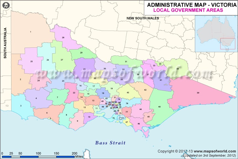
| NUMBER | NAME | NUMBER | NAME |
|---|---|---|---|
| 1 | Alpine (S) | 41 | Manningham |
| 2 | Ararat (RC) | 42 | Mansfield (S) |
| 3 | Ballarat (C) | 43 | Maribyrmong |
| 4 | Banyule | 44 | Maroondah |
| 5 | Bass Coast (S) | 45 | Melborne |
| 6 | Baw Baw (S) | 46 | Melton (S) |
| 7 | Bayside | 47 | Mildura (RC) |
| 8 | Benalla (RC) | 48 | Mitchell (S) |
| 9 | Boroondara | 49 | Moira (S) |
| 10 | Brimbank | 50 | Monash |
| 11 | Buloke (S) | 51 | Moonee Valley |
| 12 | Campapse (S) | 52 | Moorabool |
| 13 | Canberra | 53 | Moreland |
| 14 | Cardina (S) | 54 | Mornington Peninsula (S) |
| 15 | Casey | 55 | Moyne (S) |
| 16 | Central Goldfields (S) | 56 | Mt Alexander (S) |
| 17 | Colac Otway (S) | 57 | Murrindindi (S) |
| 18 | Corangamite (S) | 58 | Nillumbik (S) |
| 19 | Daebin | 59 | Nothern Grampians (S) |
| 20 | East Gippsland (S) | 60 | Pt Phillip |
| 21 | Fankston | 61 | Pyrenees (S) |
| 22 | Gannawarra (S) | 62 | Souh Gippsland (S) |
| 23 | Glen Eira | 63 | Southern Grampians (S) |
| 24 | Glenelg (S) | 64 | Stonnington |
| 25 | Golden Plains (S) | 65 | Strathbogie (S) |
| 26 | Greater Bendigo (C) | 66 | Surf Coast (S) |
| 27 | Greater Dandenong | 67 | Swan Hill (RC) |
| 28 | Greater Geelong (C) | 68 | Towong (S) |
| 29 | Greater Shepparton (C) | 69 | Wangaratta (RC) |
| 30 | Hepburn (S) | 70 | Warrnambool (C) |
| 31 | Hindmarsh (S) | 71 | Wellington (S) |
| 32 | Hobsons Bay | 72 | West Wimmera (S) |
| 33 | Horsham (RC) | 73 | Whitehorse |
| 34 | Hume | 74 | Whittlesea |
| 35 | Indigo (S) | 75 | Wodonga (C) |
| 36 | Kingston | 76 | Wyndham |
| 37 | Knox | 77 | Yarra ranges (S) |
| 38 | Latrobe (C) | 78 | Yarriambiack (S) |
| 39 | Loddon (S) | 79 | Yrra |
| 40 | Macedon Ranges (S) |
previous post
