What are Plate Tectonics?
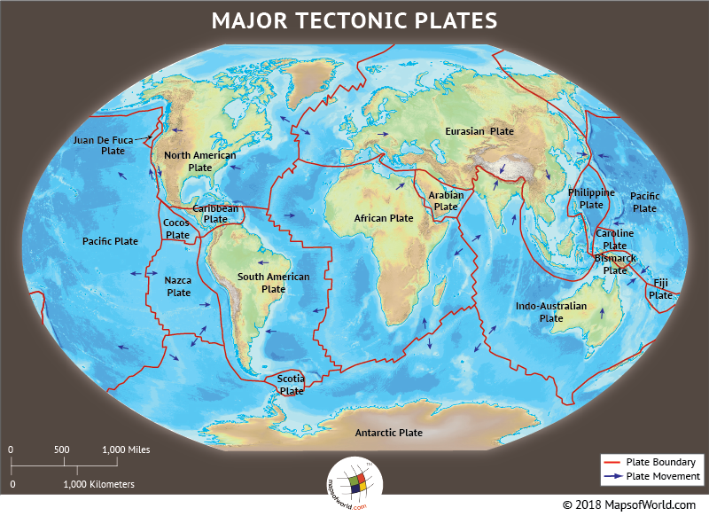
World Map Tectonic Plate
Three billion years ago, the tectonic processes began on the surface of the Earth. This initiated the large-scale motion of several major and minor plates of the Earth’s lithosphere. The lithosphere, of the planet earth, is the rigid outermost covering which includes the crust and the upper mantle, that behaves elastically over a time frame of thousands of years. This lithosphere is broken into plates called the “tectonic plate”.
Varying definitions have led to the categorization of these plates into major and minor plates, spanning across countries and sometimes continents. The edges of these plates are referred to as the ‘plate boundaries’, which are termed based on their relative motion: convergent, divergent, and transform.
A convergent boundary, also known as the destructive plate boundary, is a region of deformation, formed when the two plates, or fragments, are close to their end of the life cycle. A divergent type of plate is when the two tectonic plates are moving away from each other. Also called a constructive boundary, it is a linear feature. A different kind of plate boundary is the transform fault, where the motion of the plate is horizontal and ends abruptly, connecting to another transform. Tectonic-related activities like earthquakes, volcanic activity, mountain building, and oceanic trenches occur along these plate boundaries.
The Earth’s lithosphere floats above the highly viscous and mechanically weak layer called the Asthenosphere. Hence, the lateral density variations in the mantle lead to convection, that is the slow movement of the Earth’s solid mantle. The movement of the plates is a combination of seafloor spreading, topographical variations, as well as variations in the density of the crust. The tectonic plates are composed of both the denser oceanic lithosphere and the thicker continental lithospheric crust. The subduction of one zone underneath the other leads to the pulling of the colder and denser crust into the mantle. The material lost or pulled in the interiors, is balanced by the formation of new oceanic crust along the divergent boundaries by seafloor spreading. Therefore, the total surface area remains the same, and works on the lines of the conveyor belt principle.
There are several theories and explanations associated with the motion of plate tectonics. The dissipation of heat from the mantle is considered one of the significant sources of energy required to drive plate tectonics, either through convection or large-scale upwelling and doming. The other forces driving plate movements, then the process of subduction, can be categorized into mantle dynamics, gravity-related, and Earth’s rotational impacts.
In line with the other suggested theories, the theory of ‘continental drift’, was put forth by the meteorologist Alfred Wegener. In his book ‘The Origin of Continents and Oceans’, he states that the present-day continents were once part of a single landmass, called the Pangea. The breaking up and drifting apart of these land pieces from Pangea, released the continents from the Earth’s mantle and floated on a sea of denser basalt. The proposition was supported by the dove-tailing outlines of South America’s east coast and Africa’s west coast, and the matching rock formations along the edges. The contiguous nature was also confirmed by the fossil plants found on either side of the continents. However, Wegener faced considerable criticism from scientists and geologists, who pointed out no apparent mechanism for continental drift.
With advances in technology and new data collection techniques, the theory of ‘seafloor spreading’ was propounded. As against the theory of ‘continental drift’, which postulated the continents be plowed through the sea, the theory of seafloor spreading suggests that the seafloor expands from the central axis and carries with it the continents. The well-accepted theory was proposed by Harry Hess, who placed convection as the primary cause for plate tectonics.
The development and acceptance of the plate tectonic theory led to the prevalence of the plate tectonic revolution. The event led to a cultural and scientific change and was considered a paradigm shift and scientific revolution. While the past tectonic motions are believed to have begun around 3-3.5 billion years ago, the current plate boundaries are defined by their seismicity. The movement of the plates has caused the formation and breakup of the present-day continents and also led to the creation of some of the most striking features on the surface of the Earth. The Himalayas are said to have been uplifted after the convergence of two major plates. They were believed to have been covered by the Tethys Ocean, before their upliftment.
Based on their definitions, the plates are divided into seven major plates and dozens of smaller plates. The motion of these tectonic plates is monitored by the remote sensing satellite data sets, calibrated with ground station measurements.
Below given table mentions the major tectonic plates on the Earth’s surface:
| Tectonic Plates |
|---|
| Pacific Plate |
| Eurasian Plate |
| Indo-Australian Plate |
| African Plate |
| South-American Plate |
| North American Plate |
| Juan De Fuca Plate |
| Cocos Plate |
| Nazca Plate |
| Caribbean Plate |
| Arabian Plate |
| Fiji Plate |
| Bismarck Plate |
| Caroline Plate |
| Philippine Plate |
| Scotia Plate |
| Antarctic Plate |
Know more:
Related maps: