How were the Himalayas Formed?
How did the Himalayas formed?
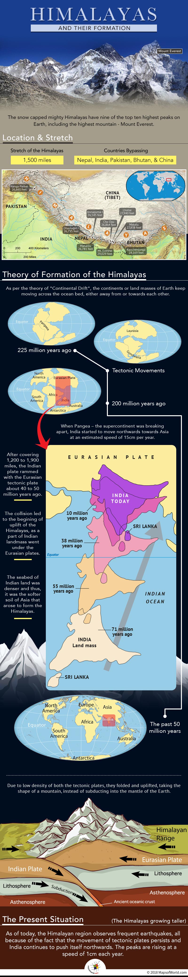
The snow-capped mighty Himalayas have nine of the top ten highest peaks on Earth, including the highest mountain – Mount Everest. The range stretches over 1,500 miles, bypassing the Asian nations of Nepal, India, Pakistan, Bhutan, and China. The mountains might have started forming about millions of years ago, but they are the youngest mountain range in this world. Are you aware that its formation continues even today? Let us divulge into the concept of ‘Continental drift’ and know interesting facts regarding their formation.
Continental drift revolves around the idea that the continents or land masses of Earth keep moving across the ocean bed, either away from or towards each other. The theory was first suggested in 1596 by a Brabantian cartographer and geographer – Abraham Ortelius. However, it was rejected by the geoscientific community. This further led to the emergence of another theory ‘Plate Tectonics’ which described the movement of couple dozen ‘plates’ on the surface of the earth.
When were the Himalayas formed?
The theories explained that before the existence of the Himalayan range, India was only an island located near the coast of Australia. Eurasian land and India were separated by a large ocean called Tethys sea. About 200 million years ago, when Pangea – the supercontinent was breaking apart, India started to move northwards towards Eurasia at an estimated speed of 15 cm per year. After covering 1,200 to 1,900 miles, the Indian plate rammed with the Eurasian tectonic plate about 40 to 50 million years ago. The collision led to the beginning of uplift of the Himalayas, as a part of Indian landmass went under the Eurasian plates. It is believed that the seabed of Indian land was denser and thus, it was the softer soil of Eurasia that arose. Since the density of both the continental crust was low, they folded and uplifted, taking the shape of a mountain, instead of subducting into the mantle of the Earth. The crust thickened after the merge, and the volcanic activity of the region stopped because the magma would solidify before it reached the surface.
As of today, the Himalayan region observes frequent earthquakes, all because of the fact that the movement of tectonic plates persists and India continues to push itself northwards. The peaks are rising at a speed of 1 cm each year. It is true that the Himalayas also sustain erosion on a large extent, but the net result is the upliftment of the mountains. The Mount Everest will keep growing taller, and it will become more difficult to climb the highest peak for the adventure enthusiasts, it seems.
Know more:
Related maps: