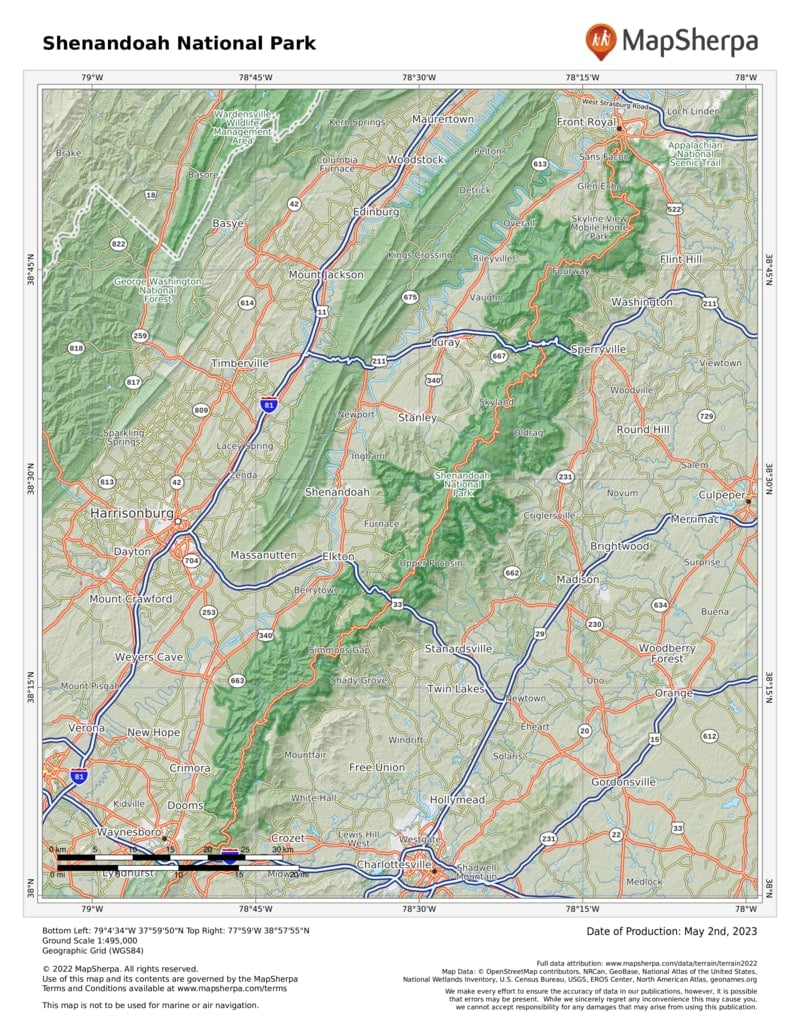
Here find wilderness, but also deep layers of human history. Unlike most national parks, Shenandoah’s borders were drawn around communities where hundreds of families lived and worked the land. As planners gave the East Coast a way to experience the grandeur of the national parks of the West, residents left homesteads and farm plots to be absorbed by the forest. Since then, oaks, hickories, and other trees have overtaken orchards and cornfields, but hikers still come upon stray chimney stacks and even gravestones. People continue to farm the surrounding area.
Skyline Drive, winding 105 miles from the park’s northern entrance to the southern exit, forms the heart of the park, which never stretches more than 13 miles across. In the 1930s, following a road engineered to hug the mountains and showcase the most scenic views, the Civilian
Conservation Corps graded slopes around the road, built stone barriers, and planted thousands of trees. Now 1.2 million people cruise Skyline Drive every year. Top speed is 35 mph, a good speed for wildlife spotting. White-tailed deer, black bears, and hawks are among the 300 animal species inhabiting this piece of the Blue Ridge.
About 100 miles of the Appalachian Trail, that 2,180-mile trek from Georgia to Maine, also course through the park, forming the backbone of its 500-mile trail system.
Paths lead to summits that make the trees below look like tiny toys, and trails wander deep into storybook forests carpeted by ferns, mosses, and mushrooms.
How to Visit
Skyline Drive is its own attraction, but keep in mind that simply driving the entire road takes at least three hours. And while the dips and curves offer delights, be sure to step out of the car. Walking among the trees and up the mountains immerses one in the park’s earthy scents, birdsongs, and fresh mountain air.
If you have less than a full day, drive to the most convenient of the four entrances and explore nearby trails and overlooks—ideally after getting guidance from a ranger at an entrance station or the Harry S. Byrd Sr. Visitor Center. To make the most of a visit of a day or more, consider starting in the middle of the park, near the Big Meadows and Skyland areas, where the mountains climb highest and popular trails and amenities cluster.
Spectacular sights can also be found in the north, where several trails showcase relics of mountain settlers, and in the less visited south, where you’re most likely to find solitude in the forest.
When crowds pack Shenandoah in mid-October, rangers suggest weekday visits. Many services, and sometimes Skyline Drive itself, close during winter, though restrooms stay open, and intrepid souls can hike in. With the trees bare and the earth wearing a blanket of snow, wildlife—and footprints—become easier to spot. Spring comes with another wash of color, when brilliant hepatica rises between fall’s discarded leaves, bluets bloom alongside trails, and other flowers blossom across the park.
Summer weekends are also popular, particularly as the park can be about 10 degrees cooler than the valley below.
Useful Information
How to get there
The park is within several hours’ drive from Washington, Pittsburgh, and Philadelphia. Where you come from will determine which of the four entrances you use: The most popular are at Front Royal in the north, near I-66, and Thornton Gap, closer to the middle, accessed from U.S. 211. Moving south, the other entrances are Swift Run Gap, off U.S. 33, and Rockfish Gap, near I-64.
When to go
Lodging books quickly for the Oct. foliage; travel during the week to avoid crowds. Most facilities close for winter and reopen in March, though the park remains open. Summers also book quickly.
Visitor Centers
Dickey Ridge Visitor Center (Mile 4.6), open daily; closed in winter. Harry F. Byrd, Sr. Visitor Center (Mile 51), open daily; closed in winter.
Headquarters
3655 Highway 211 East Luray, VA 22835 nps.gov/shen 540-999-3500
Camping
Reservations (recreation.gov), recommended for weekend and holiday visits, are accepted for all sites except Lewis Mountain. Most of the park is open to backcountry camping (free permit required); 647 campsites are available at Mathews Arm (Mile 22.1), Big Meadows (Mile 51), Lewis Mountain (Mile 57.5), and Loft Mountain (Mile 79.5).
Lodging
Private concessioners offer rooms and cabins in the park, mostly at Big Meadows (Mile 51) and Skyland (Mile 42). Lewis Mountain (Mile 57.5) has several cabins. The Potomac Appalachian Trail Club rents out primitive cabins (patc.net). For more lodging information: visitshenandoah.org.
US National Parks Map
About the Guide


