Though it’s just 100 miles southwest of Anchorage, the roadless Lake Clark remains one of America’s least visited national parks. But it’s worth taking a floatplane—the taxis of Alaska—to get there, even if just for a day trip. The park does justice to a wealth of grand outdoor options, offering wildlife viewing and fishing as well as cultural history and landscapes so majestic—dense forest, far-sweeping tundra, lakes tinted turquoise by glacial silt—it’s nearly impossible to capture their grandeur with a camera (though, of course, you should definitely try).
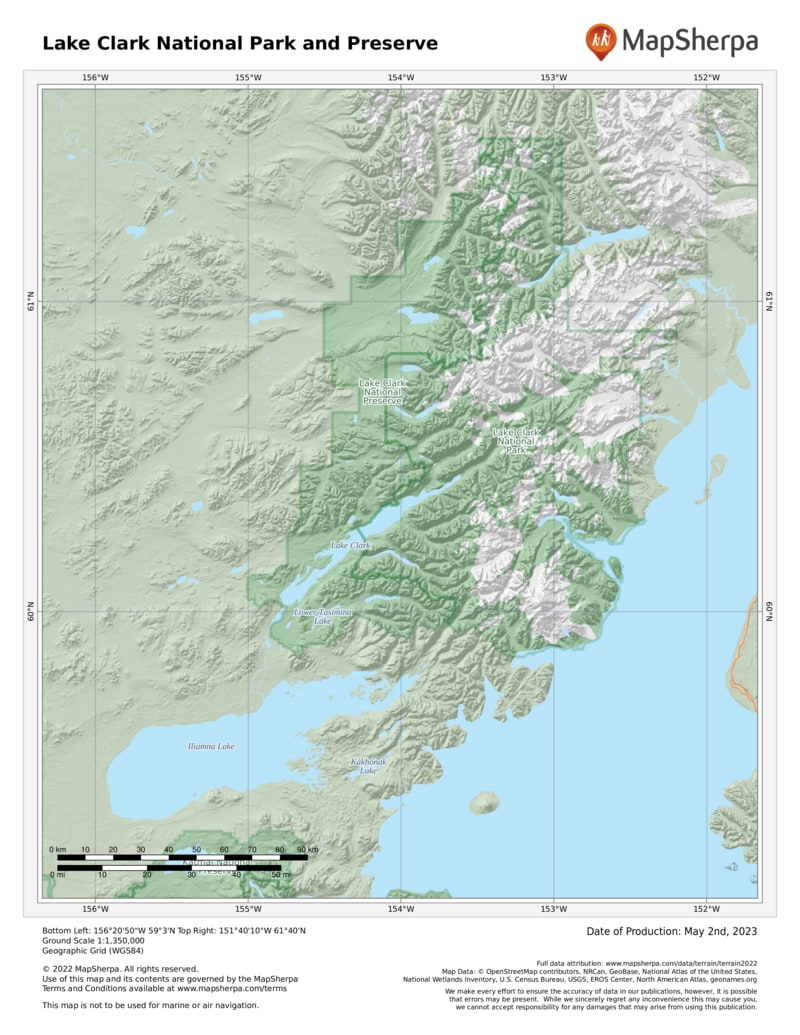
The park protects a giant swath of wilderness in south-central Alaska, just north of Katmai National Park and across Cook Inlet from the Kenai Peninsula. Boats can enter the park via Cook Inlet, but most people arrive by floatplane. Visitors commonly arrange to be dropped off and picked up at the same spot or, in the case of river trips, a predetermined place downstream.
The heart of the park, Lake Clark stretches some 40 miles. Three rivers (of many), the Mulchatna, Tlikakila, and Chilikadrotna, have Wild and/or Scenic designations. The mountains of Lake Clark dominate the views.
The lake’s geography includes the tundra of the TurquoiseTelaquana Plateau, forested areas along the coastline, and the striking Chigmit Mountains, which rise along the park’s center, bridging the Aleutian Range to the south and, to the north, the Alaska Range.
The Chigmit Mountains are home to two active volcanoes, Mount Iliamna and Mount Redoubt. In 2009, Mount Redoubt proved that southern Alaska is one of the world’s most tectonically active places.
The park’s diversity of wildlife also astounds. There are 37 species of mammals, including massive brown bears that come to feed on sedge in the salt marshes, dig razor clams, and feast on migrating salmon all along the Cook Inlet coastline. Wolves, lynx, eagles, and Dall sheep are plentiful. Add to that 187 species of birds—and fish, plenty of fish.
How to Visit
Lake Clark doesn’t have very much in the way of developed areas and park-operated services. There are no boardwalks or shuttle-bus services in the park. If you decide to venture into the park solo, keep in mind that this is Alaska—and that help is not always just a cell phone call away.
The park lacks an extensive trail system, which somehow adds a wild aspect to the park’s fine opportunities for great-outdoors experiences: paddling, hiking, camping, and climbing. If you aren’t keen on off-trail navigation by yourself, you can take advantage of one of many guide services in the area.
There are some maintained trails accessible from Port Alsworth, including the new Portage Creek Trail and the Tanalian Falls Trail.
Hiking is best around the lakes— and from lake to lake. Fishing is usually first class. If you have the time, sign up for a guided kayak.
Information
How to get there
There are no roads to Lake Clark National Park. Book a flight from Port Alsworth, Anchorage, or Kenai, or charter a floatplane. It’s also possible to get to the park’s eastern boundary by crossing Cook Inlet from the Kenai Peninsula by boat.
When to go
Open year-round, the park’s peak season runs June through mid-Sept. June and July are the warmest months, with temperatures between 50°F and 70°F. That’s mosquito time too. Wildflowers are best in late June. Aug. and Sept. are the wettest months. Autumn colors peak at higher elevations in early and mid-Sept. After that, be prepared for anything from sunshine to snow.
Visitor Center
Outside the park, the Port Alsworth Visitor Center (907-781-2117) is open June–early Sept. For general information, consult the park’s website, which they consider a virtual visitor center.
Headquarters
1240 W. Fifth Street Anchorage, AL 99501 nps.gov/lacl 907-644-3626
Field Headquarters Port Alsworth, AK 96653 907-781-2218
Camping
Lake Clark is basically a giant, mostly trail-free, camping site. There’s one primitive campground on Upper Twin Lakes, and two public-use cabins, Priest Rock Cabin and Joe Thompson Cabin (reserve via recreation.gov). Preparation is key: The weather can change quickly, and it may be difficult for a floatplane to retrieve you. It’s not unusual for a trip to run a few days longer than planned.
Lodging
There are several lodges on private lands within the park’s boundaries. For ideas check out: nps.gov/lacl/planyourvisit/eating-sleeping.htm.
US National Parks Map
About the Guide


