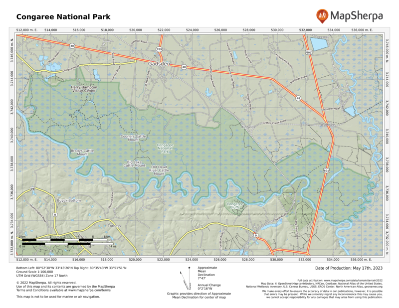
Relative isolation has always been among Congaree’s assets. Though less than 20 miles south of urban Columbia, South Carolina, the park immerses visitors in otherworldly landscapes. Park officials manage Congaree as a federally designated Wilderness, emphasizing preservation and scientific research and minimizing development.
In the wilds of Congaree, beams of sunlight stream in through perforations in the dense tree canopy, giant hardwood tree trunks look like dinosaur legs, and armies of conical “knees” rise from the bald cypress tree roots like stalagmites poking up through ferns and fungi. One park ranger described them as the clenched knuckles of a vast community of trees “holding hands” underground to hold each other up.
There are bald cypress trees deep in the woods that died more than a century ago, mostly the result of logging. The stumps that remain provide refuge for prothonotary warblers as well as for insects and fungi.
Before the days of federal protection, Congaree’s swamplike conditions protected many of its hardwood trees from ax-wielding outsiders. Still, by 1915 most of the original cypress tree population had been decimated; 500-year-old trees routinely were sent off to the sawmill. Starting in the early 1950s, conservationists led a charge to prevent further logging. The U.S. Congress established Congaree Swamp National Monument in 1976 to preserve an “outstanding example of a near-virgin southern hardwood forest.” This was the first step in Congaree’s journey to becoming a national park.
With its seasonal flooding, Congaree may look (and feel) like a swamp, but it is characterized as a floodplain forest. Some 11,000 acres of hardwood forest thrive on the nutrient-rich alluvial soils where the Congaree and Wateree Rivers merge and frequently flood.
And what of the park’s name? It refers to the native inhabitants who lived along the Congaree River. In the late 17th and early 18th centuries, the Congaree were sold as slaves, fell victim to disease (smallpox) brought by Europeans, and were killed fighting in wars with British colonists and other native peoples.
During the Revolutionary War, deep southern woods such as Congaree earned stealthy General Francis Marion the nickname “Swamp Fox.” The wilderness provided him and his men a strategic and safe haven from which to outwit British troops
How to Visit
Allow a full day for hiking—and an extra day if you want to fish or paddle. Leave your car at the parking lot; there are no roadways within the park. Named for the South Carolina outdoorsman and newspaper editor who kicked off the drive to save Congaree in the early 1950s, the Harry Hampton Visitor Center is the park’s gateway. Inside, a video and exhibits reveal the history and ecology of the park.
A synthetic bald cypress holds court in the exhibit hall, soaring through the ceiling and flaring 14 feet wide, with a hollow base for kids to explore. A framed map illustrated by conservationist John Cely chronicles the lay of the land in meticulous detail (maps are also available for sale).
From the visitor center, more than 20 miles of established hiking trails issue from the Boardwalk Loop Trail, a wheelchair- and stroller-friendly loop that links some of the park’s most impressive loblolly pines and hardwoods. Other trails that branch off from the boardwalk include the Weston Lake Loop (4.4 miles), Oakridge Trail (7 miles), River Trail (10.4 miles), and the more remote Kingsnake Trail (11.7 miles). The flat terrain makes miles pass quickly.
Anglers cast for bass and yellow perch in Weston Lake, while paddlers explore the park on the marked Cedar Creek Canoe Trail or the Congaree River Blue Trail, a 50-mile paddling trail. Whether by land or water vessel, exploration of Congaree depends entirely on the water levels, which can fluctuate by 10 or more feet throughout the year .
Information
How to get there
From Columbia, SC (about 20 miles north), take U.S. 48. From Charleston (about 115 miles south), take I-26 West to I-77 North. From Charlotte, NC (about 110 miles north), take I-77 South. All routes turn onto S.C. 48/Bluff Road; follow Old Bluff Road; park signs lead the rest of the way.
When to go
Most pleasant is spring and fall, which coincide with bird migration seasons. During winter, bare trees afford longer views. Summer is often hot and humid; the tree canopy lends a slight cooling effect.
Visitor Centers
The Harry Hampton Visitor Center is open daily. Restrooms and brochures are available around the clock. Upon arrival, check the mosquito meter over the restrooms at the visitor center. Rankings go from “all clear” to “war zone.” Headquartered at Congaree is the Old-Growth Bottomland Forest Research and Education Center, which focuses on riverine and forested landscapes across the Southeast.
Headquarters
100 National Park Rd. Hopkins, SC 29061-9118 nps.gov/cong 803-776-4396
Camping
A free permit is required and campers self-register at one of two primitive campgrounds—Longleaf (14 sites) or Bluff (6 sites). Limited backcountry camping.
Lodging
There is no lodging within Congaree National Park. Hotels and other accommodations are plentiful in Columbia, SC (experiencecolumbiasc.com).
US National Parks Map
About the Guide


