- Neighboring Countries - Mali, Niger, Benin, Togo, Ghana, Cote Divoire
- Continent And Regions - Africa Map
- Other Burkina Faso Maps - Burkina Faso Map, Where is Burkina Faso, Burkina Faso Blank Map, Burkina Faso Road Map, Burkina Faso Rail Map, Burkina Faso Cities Map, Burkina Faso Political Map, Burkina Faso Flag
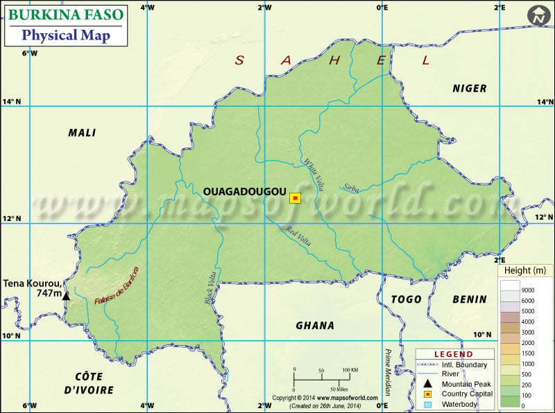
Burkina Faso is a landlocked country in Western Africa. It shares borders with six countries. It shares its boundary with Mali to the northwest; Niger is towards the northeast, Togo, and Ghana to the south, Ivory Coast to the southwest, and Benin to the southeast. One can point out the latitudes and longitudes of Burkina Faso on the map along with international boundaries. The country has latitudes between 9. and 15. N and longitudes between 6. W and 3. E. The map also highlights the capital of Burkina Faso, Ouagadougou, in a red-yellow dot and is very useful for school presentations and other purposes.
Burkina Faso Physical Features
Burkina Faso lies between the Gulf of Guinea and the Sahara desert. The country covers a total area of 274,200 km2 (105,870 sq mi), of which land area is 273,800 km2 (105,710 sq mi) and water area is 400 km2 (150 sq mi). The country is characterized by Savanna vegetation. The land is semi-arid and grassy in the north, green in the south, with sparse forest and fields. The country has no coastline. Central Burkina Faso lies on a savanna plateau mostly. This region is 198-305 meters above sea level, situated on an extensive plateau with scattered trees and fields. The terrain of Burkina Faso is pretty flat, with an average altitude of Burkina Faso is 400 meters (1,300 feet). The country can be divided into two types based on terrain:
Peneplain
A peneplain covers the major part of the country. Peneplain is a low relief plain that covers about three-quarters of the country. The elevations range from 250 to 400 m and form a moderate undulating landscape. A few isolated hills are the last remnant of a Precambrian massif.
The Koutiala Plateau (PK)
It is a Sandstone Massif situated in the southwest of the country. It is the highest and most rugged part of the country. The highest peak is Tenakourou, at 749 meters (2,457 feet). Cliffs border the block up to 150 meters (490 feet) high.
Principal Rivers in Burkina Faso
The three principal rivers of Burkina Faso are Black Volta (Mouhoun), White Volta ( Nakambe) and the Red Volta (Nazinon). These rivers converge in Ghana to the south to form the Volta River. The Black Volta is one of the two rivers in the country which flows year-round, and the other one is Komoe, which flows in the southwest direction. The Oti River, a tributary of the Volta, rises in southeastern Burkina Faso. Other than this, The Niger River drains about 27% of the country’s surface. The Beli, Gorouol, the Dargol, and the Gaudebo are the tributaries of the Niger River, which are seasonal and flow for only four to six months a year. Burkina Faso also has many lakes apart from these rivers. Some of them are Dem, Bam and Tingerla lake.

 Burkina Faso Land and People